ORH_wxman
-
Posts
90,902 -
Joined
-
Last visited
Content Type
Profiles
Blogs
Forums
American Weather
Media Demo
Store
Gallery
Everything posted by ORH_wxman
-
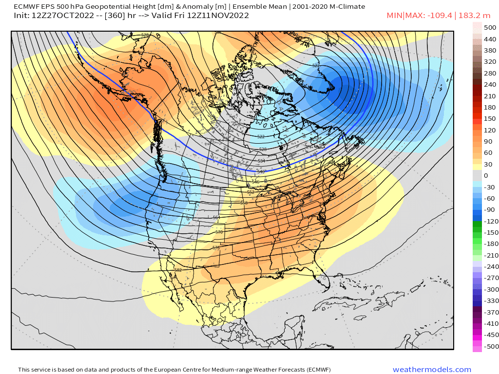
Euro also shows some of the Scandinavian ridging retrograding into Greenland at the end of the run....if that happened, that will also help push the lower height anomalies further east toward Lakes/New England rolling forward. So it's another perturbation to watch.
-
That D9-10 setup.....They usually can't get storms that cold in mid-January out there, nevermind early November.
-
Yep....though none of it matters without the QB. Jets would prob be a playoff team with a real QB. Too bad Breece Hall got injured. He looked like a stud in the making. Hopefully he comes back good next year.
-
I like the N PAC look on EPS....good -EPO. Still -PNA but we can deal with that....esp as the wavelengths lengthen.
-
First hand accounts of hurricane of ‘38 is expected now….
-
Yeah I guess that makes sense. I remember we didn’t hear about it for years and then all of the sudden the schools were all telling us to be careful of candy. Maybe it goes in phases/cycles….you get a couple incidents and everyone freaks out for a few years and then it dies down until the next incident. My kids haven’t heard of anything like that yet so we must be in a down phase of compromised candy. The only memos we’ve gotten in the past few years were to double check that candy wasn’t accidentally edibles that someone handed out…lol.
-
Yeah “poison in the candy” or “razor blades in the candy” was definitely a 1990s thing. I first remember hearing about it in the early 90s. Maybe even late 1980s. Then it kind of went away within a decade.
-
I think this time 11 years ago we were reading all those obs from southern CT where brief RA- flipped to snow and many started as straight snow. That’s when I was thinking “this is prob overperforming somewhere”….no QPF wasted.
-
Pretty heavy frost here even on the hill. Kind of surprised.
-
Devil's advocate is easy to play 5-6 weeks out too because model guidance isn't very skilled at that range.....almost anything can happen. There could be a massive pig over AK that the models don't see right now. But all else equal we'd rather not have the weeklies show it even if they aren't very skilled 5 weeks out. At least the more skilled ensembles at 2 weeks out show no sign of a terrible N PAC pattern which I think is the first thing you'd want to eliminate if you are trying to avoid a disaster (a la Dec 2011, 2015, etc)
-
These forums didn't start getting popular 20 years ago because of record high temperature enthusiasts.....you know that though since you were on them back then. Winter wx has always driven the traffic aside from some legit hurricane threats.
-
Forky pretends to hate winter wx.
-
Flatter AK/Aleutian ridge and deep -PNA would do the trick for torch lovers I think.
-
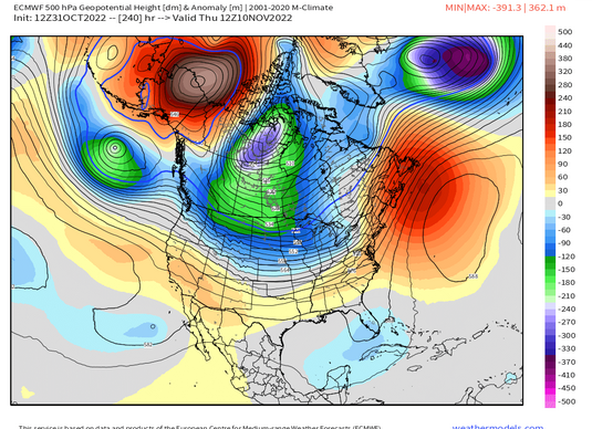
Make sure the Aleutian ridge is strongly poleward....that seems to do the best job in pushing the good stuff south. LAst year, we had a pretty flat Aleutian ridge in December which probably didn't help with that huge -PNA. That was actually one of the bigger differences between last year and a month like Dec 1970 which also had a very negative PNA. You don't like to see those lower heights north of AK.
-
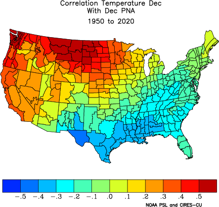
Also want to be careful in overplaying the PNA correlation....we all have PTSD from like a -4 sigma PNA last December, but that is an outlier.
-
IF we keep the PV on our side of the globe, then it will probably be pretty cold if eventually develop a -EPO/-AO combo....even if PNA is negative.
-
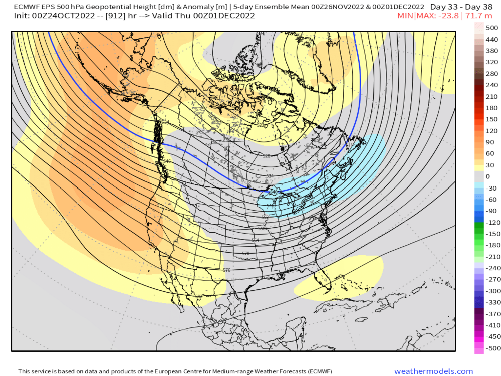
Weeklies were pretty cold by late Nov/early Dec....that was nice to see.
-
Prob a bit rushed, but even this lagged by a week to 10 days would probably roll forward into a pretty good pattern by the end of the month and early December...lengthened wavelengths would push everything a bit southeast too....which also would help the AO/NAO.

-
Yeah that isn't surprising for the observation enthusiast. Anywhere along that south coast of CT that has trouble radiating is going to be a furnace relative to the rest of the New England climate zones. Obviously even just a little bit inland in spots that can radiate (or some of the elevated zones north of the Merritt) are a different ballgame.
-
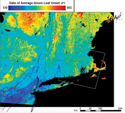
Here's a map I just found of average leafout dates.....dark blue is the earliest while the yellows/reds are much later. You can see how late the Cape is (on par with NNE mountains) but areas further west on the south coast in CT are not.
-
I don't think it's later there if at all....LI sound warms pretty fast. Further out east like on the Cape (and even S RI where's more exposed to open ocean) is a different story. But probably the only areas that would leaf-out sooner than the CT south coast are urban areas in the CT River Valley that don't radiate and perhaps similar urban areas near PVD.
-
Well to be fair, he's in a town right along LI sound....if you are in a spot around there that doesn't radiate well, it's probably one of the warmest climates in all of New England.
-
Easily the warmest station in the entire northeast and mid-atlantic.
-
Rubberband, baby.....
-
Yes and this matches what scientists have concluded for many years now. They have always been trying to find evidence of a breeding population but there are none anywhere in the northeast. Closest population from the west is probably somewhere in central Nebraska though there might be evidence they are getting into eastern portions of the state as breeding pairs. Of course, there's the Florida population too but the trip from the plains actually might be easier than from Florida. Much more hospitable habitat between the plains and New England than between here and Florida.