ORH_wxman
-
Posts
90,902 -
Joined
-
Last visited
Content Type
Profiles
Blogs
Forums
American Weather
Media Demo
Store
Gallery
Everything posted by ORH_wxman
-
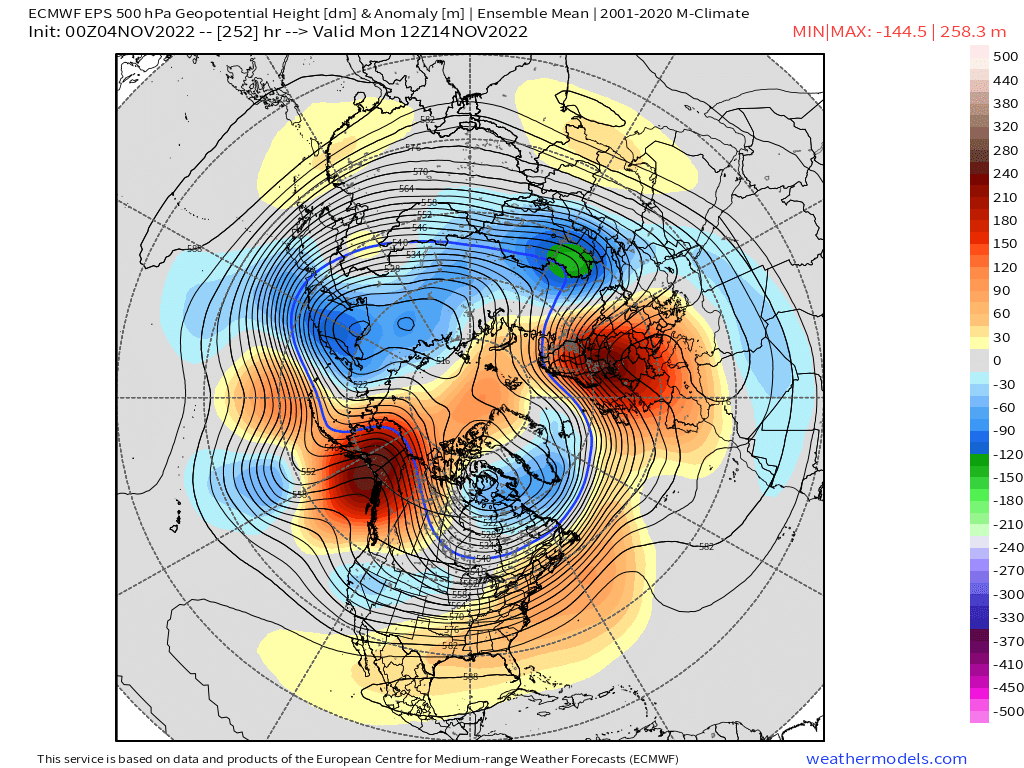
Yeah sometimes the weeklies lag the EPS by a cycle....I've noticed that. The EPS just recently went more ridging in the PNA region and that is what the weeklies weren't showing. You can see how EPS is hitting that EPO/PNA ridge....weeklies don't show this as much

-
Weeklies love December, but they keep 2nd half of November pretty meh. EPS are a lot more bullish on colder weather for mid-month and beyond.
-
The world cup is on Superstar....that's the trail that stays open until June some years.....so most of the snow will be man made. But even making snow will be very limited....only that small window. They'll have to cover it good. At least most of the week will be dry...so dry with low sun angle should help keep the snow intact. It will just need to withstand the FROPA rains next weekend which will be high dews.
-
I think the only window is Monday night through Tuesday night.
-
They better get a ton of snow down in the "cool shot" early next week....not even sure how much they can make but if they don't make it then, there's literally no way they can make any prior to 11/12. The irony is the pattern looks pretty good for them to make a ton of snow after that.
-
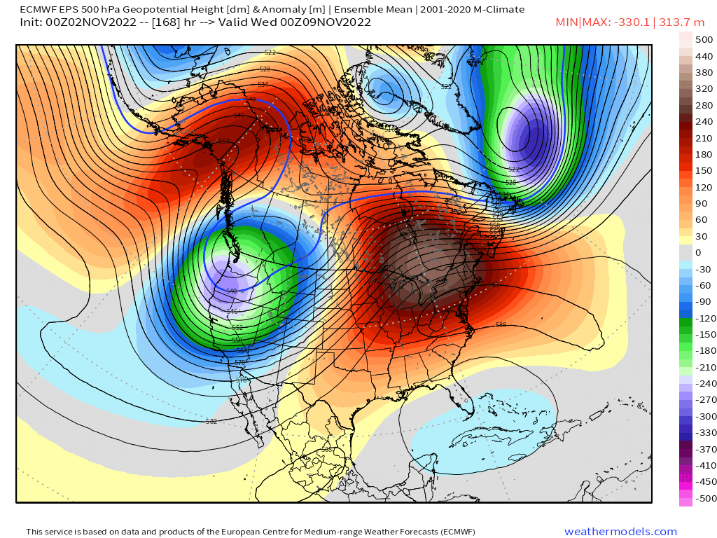
That strong pulse of lower heights SW of Aleutians showing up late in the run is interesting.....could mean a pretty huge EPO/PNA joint ridge extrapolating toward late November which is what some of the seasonal guidance was showing. Regardless, the AK heights have been consistently well above avg on all ensemble runs after this week.

-
I think about 2/3rds of the forum would be.
-
Yeah not sure why some reactions are the way they are....but regardless, the weather doesn't give a shit. It's not going to flip from excessive warmth to excessive cold on a dime either. It prob goes more closer to normal for a bit and then if western ridging takes hold, that's when we'll see a better chance as sustained below normal temps.
-
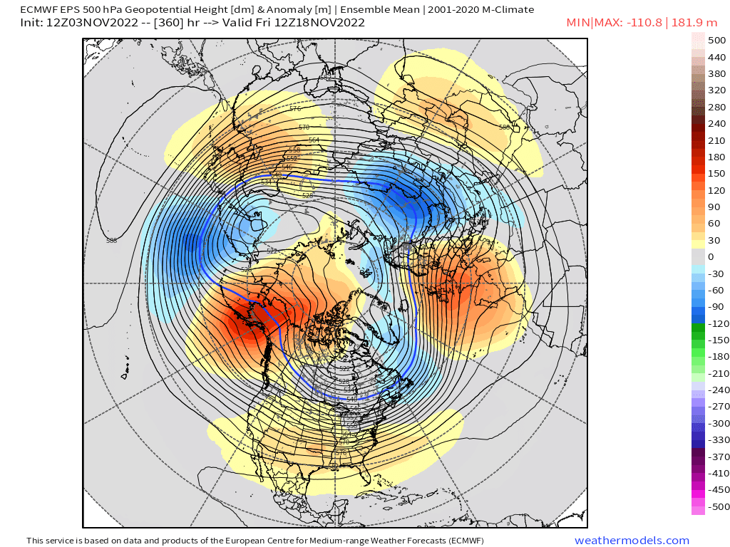
Its pretty hard to argue against a pattern change when we're going from a huge AK pig currently, to a -EPO with initial dump of cold out west (while we continue to torch), and then eventually the EPO rolling over on itself and ending the furnace here. You can argue whether that means first snow chances or just merely chillier/normal weather for mid/late November, but it's a far cry from what we've seen and what we're going to see for the next week to 10 days.
-
12/29 was pretty huge but only in a narrow zone from N RI to metrowest BOS suburbs where several places had 18"+.....we just lacked a region-wide big dog. Jan '77 had some SWFEs on 'roids and a late bloomer miller B, but still not high end top 10 type stuff.
-
Yeah that's why I want it in early/mid December when the climo is more precarious. Gives us more wiggle room. Later December into January we can still do ok in a lot of flawed patterns as long as we are avoiding the AK pig.
-
Forgot about '76-77 too....prob pulled it off in your 'hood. ORH fell just short because of December. But 12/29/76 crushed the 128 belt out east.
-
Hopefully it retrogrades by December...sometimes it can take a couple weeks to do it.
-
Big torch the next week and a half or so and then changes are coming it looks like.
-
Yeah it's not really feasible to go wire to wire. 1995-1996 did have all 4 big snow months above normal (Dec/Jan/Feb/Mar) but we obviously had that brutal thaw in 2nd half of January. 2000-2001 over the interior did as well. That year is prob the closest since it didn't have any brutal thaws after the 12/17/00 cutter (there were two small snow events in the week after that too which saved white Xmas) Only other one off the top of my head was maybe 1960-1961. '04-'05, '92-'93, and '93-'94 were all close but no cigar. They all had one month that was more like average instead of above avg. '07-'08 prob pulled it off in NNE.
-
They can get some obscene snow totals out there in November. Stuff you just can’t find back east even in our cold airmasses that early in the season.
-
There seems to be plenty of agreement on big AK positive height anomalies by mid month but the PNA region is a little muddier. But it’s been trending “ridgier” out there.
-
That was a great event. Had over 8” in that which then produced a white Tday a week later because it really didn’t melt much. Had the coldest November day on record in most spots on Tday that year too.
-
OH i can see that too....my suet feeder is usually hogged by the larger woodpeckers but we do get the chickadees and nuthatches on it when it's free. Blue Jays use it too, esp in winter. I really need to get one or two more.
-
OP GFS trying to hit the PNA ridging too mid-month and beyond. It also produces the first snow threat in that time which would certainly be a possibility if we were able to get that type of western ridging and cold delivery. Ensembles will be more useful than OP runs, but they are all showing the same general theme today.
-
Chickadees don't sit and eat at bird feeders.....they typically grab one seed and then fly to a nearby branch or perch and eat the seed there and then return to the feeder for another one. Rinse and repeat. Titmice and nuthatches behave the same way. We have a ton of them that come to my feeders....prob seen 6-8 chickadees at once before near the feeders but typically not all on the feeder at the same time as they are in different stages of flying to and from the feeder after grabbing a seed. Years ago, I read one theory on why those types of bird do that and it was because their beaks aren't strong enough to crack open sunflower husks, so they need to peck at it while holding it down on a branch to open it. Finches, grosbeaks, cardinals, etc all have much stronger beaks that can crack open the sunflower in one shot.
-
Yeah when the EPO block "Folds over" itself, the next upstream trough tends to rejuvenate it in the PNA domain or at least closer to the PNA domain....you can kind of see it when we loop the EPS from about day 7 through D12.

-
The western ridging over PNA region is a new development out in the extended EPS. That would make the change more abrupt after mid-month. We'll see if it sticks.
-
Def not fake if the non-rad spots freeze. That’s usually pretty chilly during daytime too on those airmasses.
-
Euro and EPS both are trying for a cold shot around mid-month now. Might be the first freeze for the non-rad spots. FWIW, ORH latest freeze on record is 11/12 (1977 and 1916) This year has a legit shot to break that record.