

ORH_wxman
-
Posts
90,902 -
Joined
-
Last visited
Content Type
Profiles
Blogs
Forums
American Weather
Media Demo
Store
Gallery
Everything posted by ORH_wxman
-
Flip the switch to winter and avoid the 4-6 weeks of 45-50F garbage.
-
Yeah avg high at ORH on Dec 1 is 41F. Prob mid 40s lower elevations. If he’s expecting/hoping consistent 20s, that won’t happen unless you get something like 1989. Pretty hard to get -15 daily departures for more than 7-10 days at a time.
-
SWFE type pattern there.
-
Yeah that’s a decent look. It’s been on guidance for a couple days now. Tip and I have discussed it a bit. That general pattern in the 11/16-11/20 range is favorable as far as November threats go.
-
11/16-11/18 period keeps showing up for a potential winter threat. Early season caveats apply of course…NNE or interior elevations most likely to see anything that early.
-
Is that gonna get counterfeited later? Seems like it could be closer to 60 before midnight.
-
You may be correct on this depending on the timeline. I think a lot of people are probably ignorant of how warm New England was in the late ‘40s through mid-50s. In fact, there’s a lot of sites in New England that still have their warmest year ever as 1949. At least when I checked a few short years ago. Maybe that list is smaller now, I’d have to check again. But it shows just how extreme some of the warmth was around the middle 20th century here. So when we cooled in the following few decades, we had plenty of room to come back up as the underlying forcing asserted itself. And yes, nighttime mins have warmed faster than daytime highs. That’s pretty consistent with the warming climate as higher vapor make rad cooling harder and it also makes the high-end temps more difficult to achieve (as we already discussed). I do find the temporal/spacial differences fascinating in their own right.
-
Yeah it’s the frequency which changes the most. The actual high end temps haven’t really gotten hotter…high water vapor prob helps offset that some. But the frequency of warm spells has gotten higher. Hard to replicate the 1930s dust bowl conditions over the CONUS with the high water vapor environment we have now and corn fields/farm land that is better managed. So getting those 110F+ bombs in places like Ohio/PA are just not gonna happen like back then when they did it a bunch of times. I will also push back on Tip’s claim somewhat about us being “insulated”. Maybe only in the summer at the high end, but from an average temperature standpoint, New England has warmed faster than almost anywhere in North America in the past 20+ years outside of the arctic regions. There would prob be a bunch of people in the northern plains and Rockies looking at us funny if we told them about how winters ain’t what they used to be a couple decades ago….they’ve actually gotten colder out there compared to the 80s/90s.
-
What we’ve seen on some of these model runs is a longer wave trough setting up over the east and then you have a shortwave(s) diving into the longwave trough…that’s typically a favorable “look” for getting something. Esp this early when you need the cold solidly established. That’s kind of what you might mean by just looking at it….years of experience tells us that we “like” that look for winter threats. We know subconsciously that we need extra cold established for an early season threat, and the best way to do that is a deeper longwave trough putting the ambient cold overhead in place and then getting a shortwave to amplify into that. Of course all the caveats apply at this range. Could easily look different next week. But right now, it has a shot.
-
Tomorrow we make model watching great again. And extra sleep tonight.
-
Nice job CFS.
-
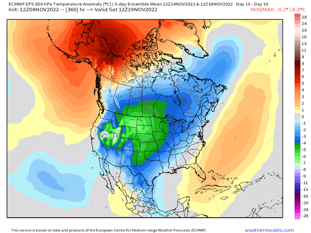
Oh yeah, you have the heat exactly where it will be coldest this month. I can see why you are not liking those analogs now.
-
Did you originally have November really cold? It looks pretty damned cold across the CONUS 2nd half of the month (N plains and Rockies almost the whole month). Might just have to back your timing up. Things could always change of course. Maybe model guidance is too bullish on cold later this month.
-
Yeah let’s back that west about another 75-100 miles. 12-15” for ORH hills? Can always adjust up if needed.
-
Some guidance showing potential for first winter threat near mid-month? Both Euro and GFS trying to show it…though via different mechanisms.
-
‘02-03 was pretty awesome from a length standpoint. We started in October that year (3 inches at ORH on 10/23/02) and then had 3 November events (snow to sleet to ice on 11/16-17), 6-10” on 11/27 day before Tday, and then 1-2” a couple days later with the warm front lifting back north… Then of course Dec/Jan/Feb were great (a little less so along coast Dec/Jan), and then we even had that frigid week in April 2003 that produce a couple snow events. And it was a really cold winter as well. Underrated for cold.
-
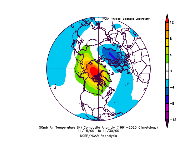
Those are November composites. Not winter.
-
That doesn't look like a bad forecast for this November either. We're going to prob finish above normal here because the first 10 days are so warm, but it could get close if we have a cold 2nd half. Plains and N rockies will be frigid.
-
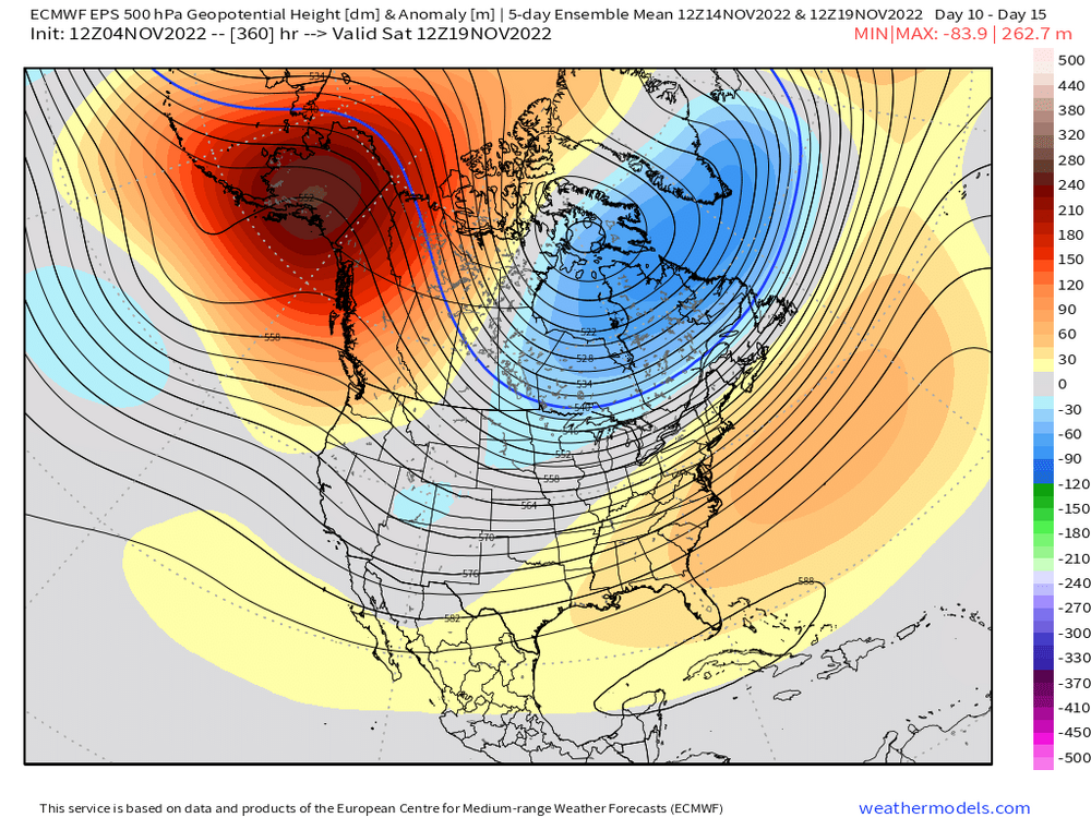
Yeah nice look on the 5-day mean anomaly.....that's a ton of cold in the plains and Canada (and cold over us, just not overly frigid)
-
EPS trending colder too toward mid-month. It's more poleward and further east with the AK ridging.
-
Mar '03 was below average here in snow....though not sure down where you are. You might have been closer to normal with the 3/6/03 event doing better south.
-
Trying for the more -AO near the end? That would be nice to have with the -EPO.
-
-
Relationship is kind of weak, but all else equal, you like to see the warm anomalies in the stratosphere in the eastern portion (toward Bering) of Siberia in mid/late November. 50mb charts show that which is good. That has historically meant a better chance for blocking. But like some of these other stratospheric and blocking relationships, I wouldn't weight them too much.
-
Yeah I'd love to have snow the last week of the month, but everyone knows the climo....there's a reason most of the forum outside the elevated areas of CNE/NNE average between 1-4" in November. it's a really good sign that there is no sign of the AK pig returning. That's the biggest thing I'm following.


