ORH_wxman
-
Posts
90,902 -
Joined
-
Last visited
Content Type
Profiles
Blogs
Forums
American Weather
Media Demo
Store
Gallery
Everything posted by ORH_wxman
-
All about rates....if it's SN- at 33F for 2-3 hours, it's gonna be mostly coatings to an inch...but if you can sneak in an hour of SN or SN+ at 31-32F, then there will be some 2" amounts prob.
-
I hope they didn't cancel the Cup at Killington because of that.....looks great for them the next couple weeks. Both man made and natural snow should be plentiful.
-
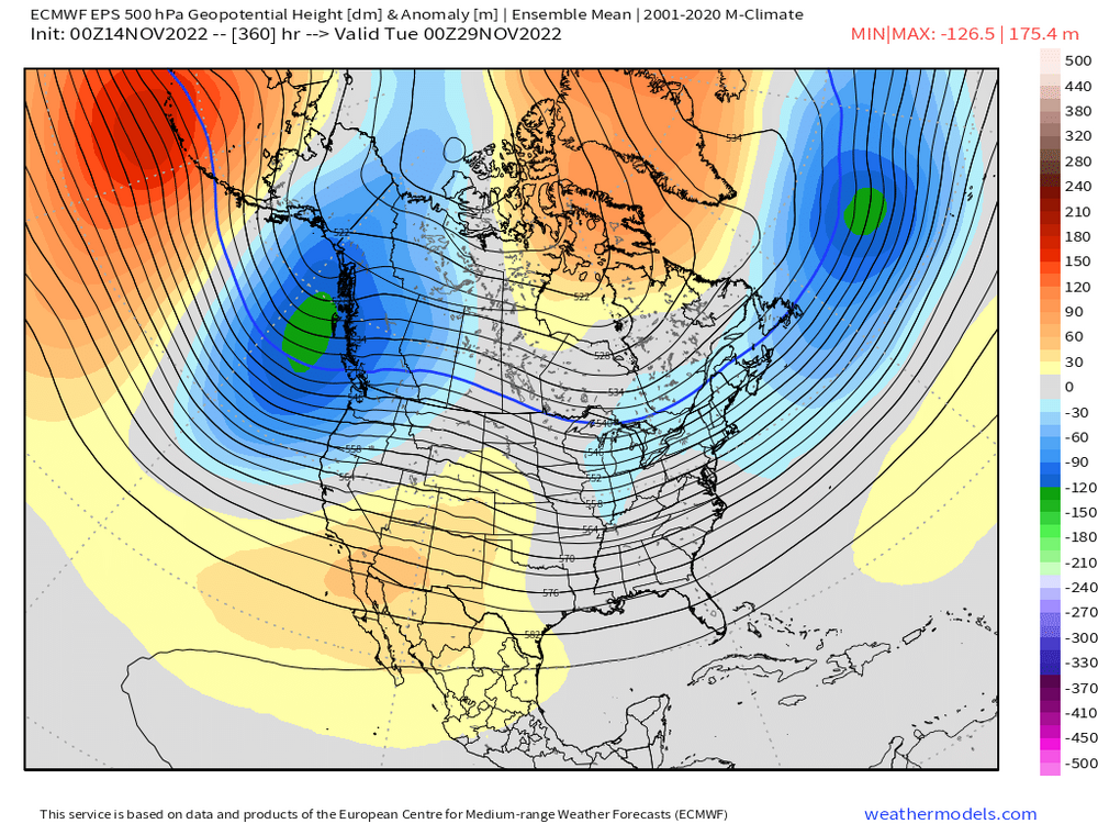
You can see the AO/NAO trying to ramp up on the EPS. We lose the PNA ridging out west but at least we still have cross-polar flow via the -WPO. This pattern isn't super cold, but it's not warm either. Prob a lot of chances in that type of pattern if it holds into December.
-
That sounding looks like the precip is ended.....completely dried out in the mid-levels.
-
Yes. Even back in the day in ORH I sometimes felt a little neglected by Boston Mets but it wasn’t nearly as bad as areas NW of ORH put toward ORE.
-
I dunno, I always had Syracuse at the top of my mind when I made forecasts for interior New England.
-
It probably would’ve helped the artist if they used a map that didn’t cut off a third of Maine.
-
Apparently the monadnocks aren’t interior New England. And all that time when I was issuing forecasts I never knew…..
-
Yeah we’ll see. We still may get a little event. Just because models don’t have one at day 8 or 9, doesn’t mean one can’t pop up.
-
Sure it does normally without any context with it, but his context was “NNE and maybe into interior SNE” which means you’re looking at the northern part of SNE. I really wouldn’t get hung up on it. We might get an event and we might not. But latitude is really favored this early. Even places like CON and southeast NH at lower elevation average more snow in November than ORH hills even though the latter averages more in a season…the interior elevations further south just make up for it later on.
-
You gotta translate DIT posts into his language. If he’s only thinking a 1-3” event might happen, it really means some flurries and maybe a few snow showers.
-
“Interior….even into SNE” is going to favor places like N ORH county out to Berkshires. Your interior but pretty far south in context to where NNE/CNE turns into SNE.
-
Yeah I think many will see first flakes from flurries/dying snow showers late next week/weekend…esp over interior if they don’t see them early Wednesday from that system approaching.
-
EPS was sort of siding with keeping the cold through Tday…even if not quite as cold as later next week/weekend. It seems the -EPO evaporates and sort of goes more into a -WPO pattern but there is still some ridging in the AO region.
-
Agreed. H5 anomaly would be way more useful.
-
Got up to 73 here. But right now 67F so slowly starting CAA. As for beyond today, euro pretty close to starting interior as a burst of snow. Mostly N of pike but can’t rule out a few flakes at start south of pike on early Wednesday morning. Euro has a solid advisory event for NNE. Maybe low Tip is also right about the model guidance still being divergent on what happens beyond next weekend. Some try to relax the flow and go to seasonably mild weather (but not epic torch levels like we saw so far this month)…and others like GGEM keep the cold around.
-
That was winters revival in SNE too after a bit of a break with some messier/mix/warmer events in early February. We rebuilt the pack to around 25-27” in ORH during that period after it had been matted down to like a 6-8” glacier. There was a lot of water in the pack by mid March. Luckily it was a very slow melt off with dry weather mostly in late Mar/early Apr.
-
Up there you’ll likely have a few sub-freezing highs.
-
Sure you can try but you’ll look ridiculous if the empirical evidence doesn’t back you up.

-
Shaping narratives is the thing on here the past 5-8 years. We’ll run the numbers when the next 2 weeks is done. My guess is the next two weeks (after tomorrow…so from 11/13-11/26) average well below average temps. Prob somewhere in the -6 to -10 range. You can’t really lie/spin effectively if empirical evidence is opposing your narrative.
-
Is that run off of the KFS or Vice-versa?
-
There’s a chance it trends colder. It’s still 5+ days out. But there’s more ways for it to rain this early so that’s the safe forecast. My guess right now is that if it did start as snow, it would be short lived.
-
There’s a chance is starts as a bit of snow but I’d prob lean against it right now.
-
3 weeks from now that system would prob be a really good SWFE. But prob mostly an NNE event this time and at elevation.