ORH_wxman
-
Posts
90,892 -
Joined
-
Last visited
Content Type
Profiles
Blogs
Forums
American Weather
Media Demo
Store
Gallery
Everything posted by ORH_wxman
-
The staff will set the subforum so that only DIT and the Pope can post for 24h…all confessions will occur and then we can move on into winter.
-
We had a legit pattern both of those winters.....we got a bit unlucky last January except for those folks right near the coast who saw 24-30" in the blizzard....but the pattern easily could have yielded more events. But even still, I think ORH had like 25-30 inches of snow during these 3 weeks and it could have been another 12-15 more if that ridiculous Jan 17th storm hadn't produced like a 1 in 50 phase that cause it to run up our fannies. Then the previous winter, we had a very good pattern from around MLK until mid-February. We got like 40 inches of snow during this period. I think 2020 might be the year you are thinking of when all the ensembles showed an obscenely good pattern around mid to late January and then it just evaporated. LAst year, we did have some false starts in December, but we did get the good pattern in January....we were just a little snake bit from what-could-have-been due to Jan 17th.
-
Agreed....I like when it retrogrades from existing Scandi ridging....because it's usually less of a model phantom and more likely to be real. Many of the bigger NAO blocks we have experienced evolved from a retrograding Scandinavian ridge or block.
-
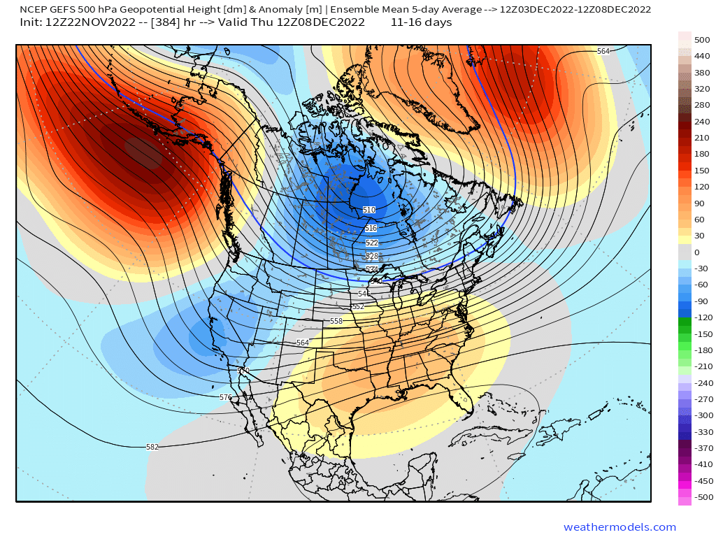
Pretty intense for D14-15
-
It's been a while since I've seen the EPS this bullish on NAO blocking that far out in the run....the mean is like 250dm anomalies for D14-15
-
I share the same wish during the holiday period....but most of our great Decembers and white Xmases happened because of snowy periods in mid to late December and not because of snow on December 2nd or something. His expectations of the T-day through December 5th period are completely unrealistic....it's like a 1 in 10 shot at best of what he wishes for. Maybe even less since he also never wants it to melt if we happen to get a snow event during that period.
-
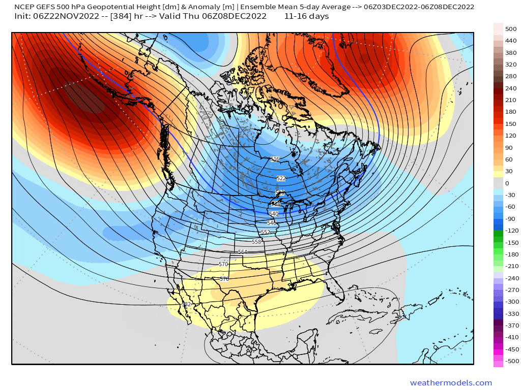
They actually look more like the GEFS from last night....a bit less SE ridging.
-
How do you know we're getting no snow through 12/15? That is news to me.
-
I believe you have been a member of this forum for over a decade.....you know how he rolls by now. If it's not wall to wall winter storm threats and permanent snowpack by the first couple days of December, he starts posting about losing half of the season. It's probably about 50% reverse psychology and 50% truly unrealistic expectations if I had to guess. For those who still believe in empirical numbers....at 1000 feet in central Massachusetts (so by default, colder and snowier than most of SNE), average snowfall in the week leading up to December 5th (so 11/27-12/4) is 1.9 inches and more than half of the years saw no measurable snowfall at all. Only 11% of the seasons saw an advisory (or better) event during that period. Conversely, in the week following that period, the average was 4.4 inches of snow and only 21% of the years saw no measurable snow in that week while 19% saw a warning snowfall event (6" or more) while 27% saw at least an advisory event. The climo is vastly different once you are into that period.
-
Lots of Kevin tantrums in here over the next 10 days complaining that there's no deep snow cover by 12/1.
-
GEFS pushing the SE ridge a bit more....looks closer to EPS from last night. That's a pretty good pattern though for here....problematic down south though.

-
Not very interesting for SNE, but Friday may see some light snow in NNE ski areas. That northern stream that cuts loose from the southern cutoff bring s aband of precip through and it's cold enough for snow up there.
-
Right on schedule because mid-November average temps are right on par with early April. Though early April skews a little snowier than mid-November.
-
I can't believe there are geese still here and it's not deep winter on 11/22. How can that be?
-
Need an official Papal ruling.....does this count as a confession of sins of claiming no pattern change?
-
November is typically either "First flakes" or "first measurable" for SNE...the latter being usually over the interior. I think ORH has had something like 60-65% of Novembers seeing measurable snow in the past 30+ years. This year already had 2 inches there, so first measurable is already out of the way. I'd say for December, typically the interior should see an advisory event by 12/10-12/15....and the coast is maybe a week later on average. Often they get them at the same time, but there are events where it doesn't work like that....Dec 5, 2020 is an example...I think ORH had 9.6" of paste while the coast had an inch of glop. The coast got in on the action in the 12/17/20 storm.
-
The irony in this is that the pattern actually looks pretty good for early December....I wouldn't be shocked if we have a good system pre-Dec 10th. But apparently that isn't good enough....we need to have the once-in-40 year November biggie.
-
Sometimes a few people get confused and forget that climo in their backyard isn't Rangeley Maine. If we aren't covered with permanent pack by December 1st, we're "Wasting winter".
-
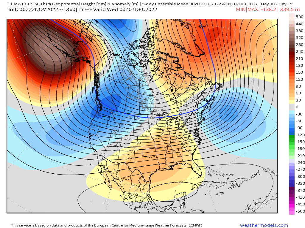
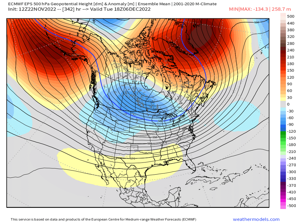
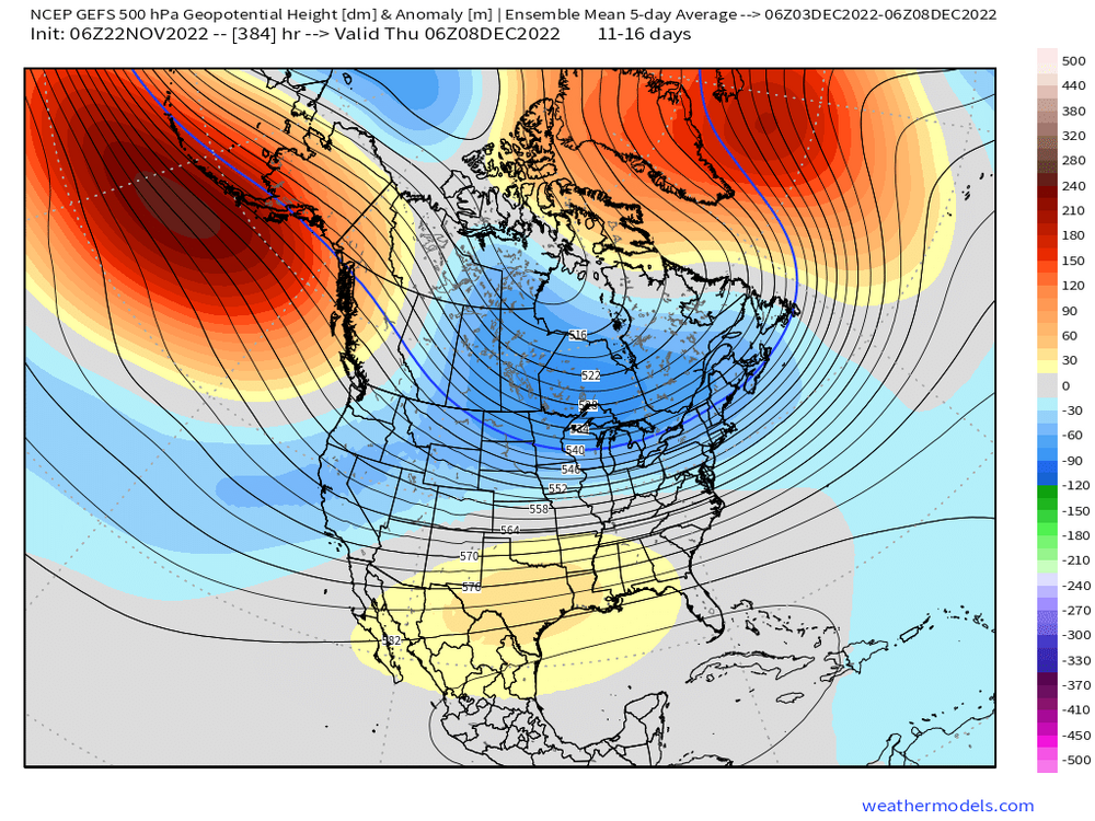
This is the 5 day mean on each ensembles suite....basically covers the first week of December (minus the first day or two) GEFS looks more favorable than EPS, but EPS is still totally fine. In both cases, the Atlantic blocking is actually retrograding at the end of the run so it probably gets better beyond that.

-
This is why I love this forum.....every November....rinse and repeat. The funny part is if we had gotten a snow event last week, all of these same people would've said "We're wasting a good pattern in November!!!! It's going to turn to crap by mid December!11!!#2!"
-
Almost looks more appropriate for November now. A cold rain for many on that type of solution where maybe the interior hills in N ORH county and monadnocks end as brief 34F noodles and places like VT/N NH mountains end as 3” of paste.
-
-PNA/-NAO is one of my favorite patterns provided the PNA isn’t taking a dip on the beaches of Cabo San Lucas. This version on the ensembles is solid. SE ridge is modest with good confluence to our north. Unfortunately I expect to see plenty of shifts on the ensembles but as long as we keep the Atlantic blocking and avoid full blown AK piggies, I’ll roll the dice.
-
More importantly is the low height anomalies are in a great spot there near 50/50 region.
-
Nice look on both GEFS and EPS in early December. That’s quite the change compared to a couple days ago. Model volatility is back….like it’s 2007 again when you had no idea what was going to happen 12 days in advance.
-
Nice to see the change for better on EPS going into early December. Pretty nice look on the 00z run. Model volatility has been really high though, so hard to trust anything past D7-10 on the ensembles. It definitely looks like we relax back to warmer for at least several days in the 11/25-12/1 period.