ORH_wxman
-
Posts
90,892 -
Joined
-
Last visited
Content Type
Profiles
Blogs
Forums
American Weather
Media Demo
Store
Gallery
Everything posted by ORH_wxman
-
Yeah if we're rooting for an all time exotic frigid slow-moving blizzard.....it's probably the pattern we want. But even aside from that, the slower flow should help amplify more shortwaves instead of fighting meat grinder fast-flow.
-
Yeah those are probably the last two winters I saw something like that. Basically taking the flow straight from Siberia into the CONUS.....a true "Siberian Express" pattern.
-
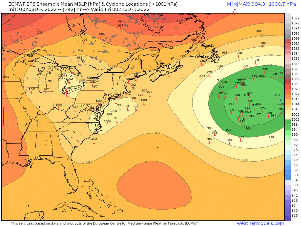
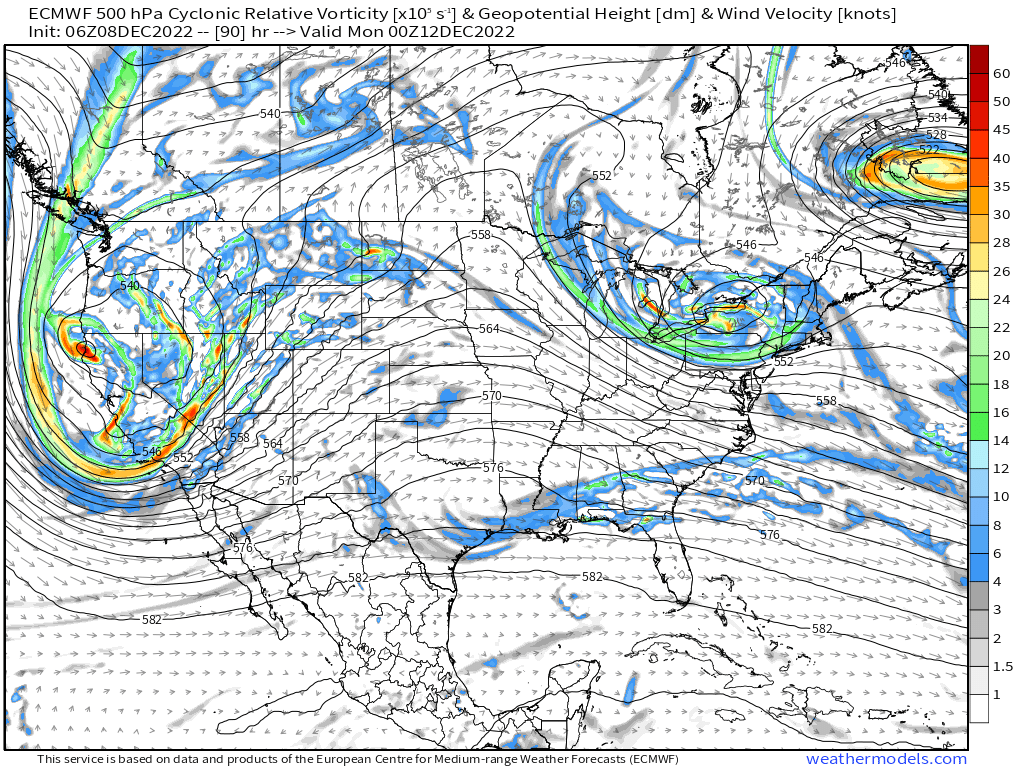
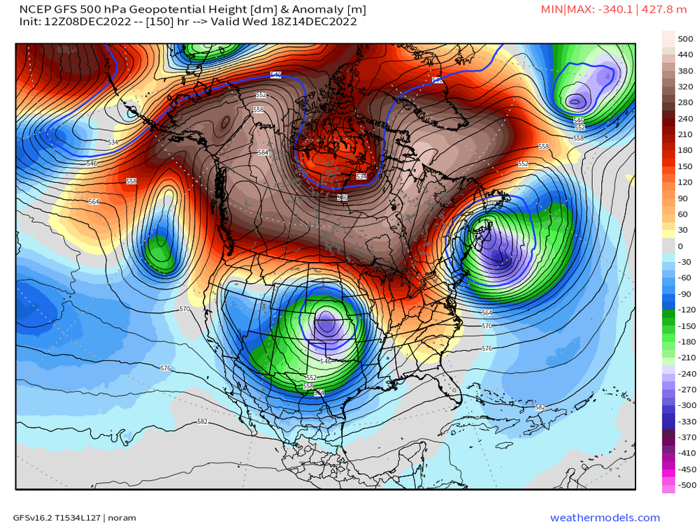
The magnitude of that AK/EPO ridge is something I haven't seen a long time for an ensemble mean that far out....it's showing up on all the ensemble guidance too. Not just one suite. It's builidng all the way into the East Siberian Sea.
-
Hopefully you can track some OES/IVT action too

-
You might get more from Monday than 12/16....lol.
-
I mean....it's a D7-8 threat. Don't put he cart before the horse on expectations.
-
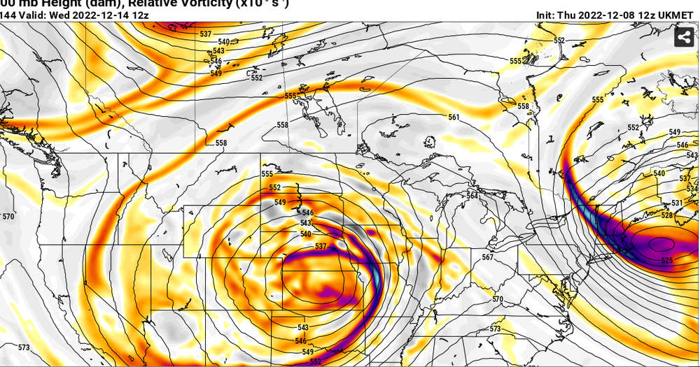
What in the hell is this from the Ukie....the fishermen on George's Bank are gonna disappear into a vortex
-
Lol....maybe wait until the pattern breaks down at least.....prob gonna be several more chances after 12/16.
-
Decent front ender for 12/16 over interior SNE (prob N&W of 495) on GFS. Coast is torching with onshore flow in that setup. But obviously that could change as we get closer. That high to the north is funneling a ton of dry polar air to help prolong the frozen over interior.
-
Super amped solutions with widespread 12-18" of snow are not coming back. But the way to get sneaky warning snowfall will prob be from a stripe under good fronto....like the GFS had. Pretty cool that you can actually see what the PV lobe was doing on those huge solutions....it was retrograding further west so that the shortwave had room to amplify underneath it rather than staying to the northeast and acting as an inhibitor to amplification.
-
We need the "Day After Tomorrow" map that dendrite posted a few days ago.
-
What the hell is going on for 12/16? GGEM and GFS both have the 50/50 low getting pushed south into Maine and the GFS then pushes it into the waters east of NE, lol. Some crazy looks ahead of that system.
-
Significantly north of 00z though
-
Nice stripe of warning snows in NE CT into N RI and maybe tickling interior SE MA?
-
GFS is def coming in a bit more zonked.
-
ICON and RGEM looks pretty good for widespread light snow over much of SNE for 12/11-12. We'll see what the globals do. The 06z EPS still has some pretty big members in there for 12/12. I don't think they are likely, but can't rule out a little surprise yet.
-
Take under on temps....even NAM has it stuck in the upper 20s all day Sunday away from immediate coast. That's quite chilly from the northeast.
-
Yes, though there could certainly be a heavier stripe somewhere. We'll just have to see how vigorous the shortwave is when it is knocking on our door. I wouldn't be forecasting much for our area right now (maybe more bullish in SW CT), but there is kind of a low-grade bust potential on that one.
-
I think it's just DJF....I recall BOS squandering their shot at futility in March 2007. I don't see the point in leaving March out though....that is a snowier month in some places than December is. I could sort of see an argument for discarding months like Oct/Nov/Apr.
-
That must just be DJF? BOS lowest for the whole cold season is 9.0"
-
This is pretty interesting on the EPS

-
Yeah I will be going more bullish if this is the real track of the vort and shortwave..... Now if it ends up south of this depiction, then I would fade the snowfall, but I'd be surprised if there isn't at least widespread steady light snow if it looks like that aloft. Even if it's just an inch or two.
-
That’s why true top end blizzards are the best. You get the 50mph winds and insane sensible wx conditions plus a transformed moonscape, except the snow is so deep in those that you don’t have any bare grass areas. It’s more like 8-10” in the low spots and 4-5 feet in the high spots. Storms like Jan 2005 and Feb 2013 were like that. Really windy but such top end snowfall totals that you couldn’t blow the ground bare.
-
Boxing Day must have been your favorite. 50 mph winds whipping dryslot snow grains.
-
Not out yet. Prob 20 min.