-
Posts
90,892 -
Joined
-
Last visited
Content Type
Profiles
Blogs
Forums
American Weather
Media Demo
Store
Gallery
Everything posted by ORH_wxman
-
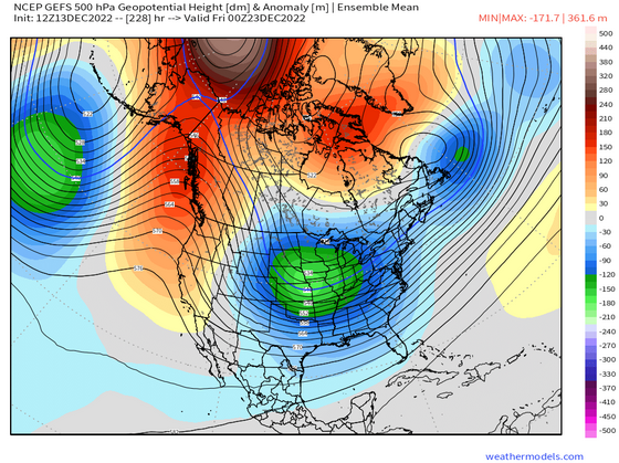
You also still have a large Baffin/Davis Strait Block there trying to pin part of the PV lobe under it.
-
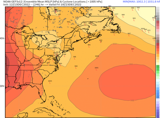
Do we really care what the sfc low means are at 220 hours? I mean, 5-6 days ago, this friday's system was cutting into Ottawa and sending parakeets to Caribou....but the hemispheric pattern always said watch out for further SE solutions because when you have Baffin and Hudson Bay blocks, they usually do that. Plus, the GEFS looks like buckshot to me....lows in LAke Huron and lows over George's Bank.
-
I don't see this at all....it could cut if western trough digs and we lose confluence, but how do we get "storm will cut by a good amount" from that ensemble mean look? Here's the GEFS. Still waiting for EPS to come out far enough, but I doubt it looks super different.
-

Preliminarily ... a medium impact partial Miller B, Friday
ORH_wxman replied to Typhoon Tip's topic in New England
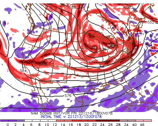
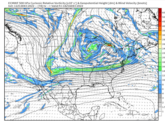
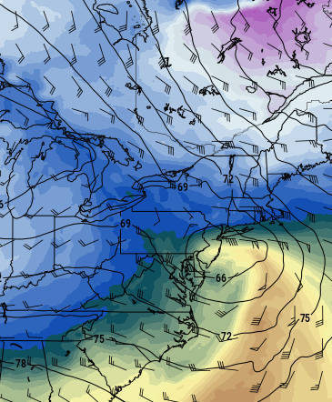
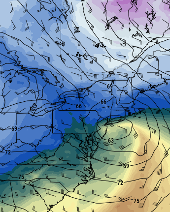
Here's what I was talking about....look at the NAM whil it is still south of New England: Here is the Euro at the same time...note the lack of "curl" in the H5 heights south of NE. It's not really doing it until it's almost overhead which keeps us without good dynamics. -

Preliminarily ... a medium impact partial Miller B, Friday
ORH_wxman replied to Typhoon Tip's topic in New England
Most of SNE is under an inch of qpf through 84h....that isn't really going to do much outside of like the highest terrain well in the interior. We need that H5 protrusion to start curling back to the NW a bit earlier for the good dynamics like the NAM did. -

Preliminarily ... a medium impact partial Miller B, Friday
ORH_wxman replied to Typhoon Tip's topic in New England
Well that is a slight improvement from 00z....but not from 06z. Dynamics look kind of weak sauce this run -

Preliminarily ... a medium impact partial Miller B, Friday
ORH_wxman replied to Typhoon Tip's topic in New England
I have no idea....Ukie always just absolutely furnaces the low levels, so I don't really try and parse it outside of the synoptic tracks. Might have to do with how strong the lift is on the model at any given time, but usually I just completely toss the Ukie thermals and try and look at the track of systems on there if ptype issues are an issue with the storm. -

Preliminarily ... a medium impact partial Miller B, Friday
ORH_wxman replied to Typhoon Tip's topic in New England
Ukie def came SE some....still torching the low levels (what else is new for Ukie), but I like those ML tracks much better than 00z....850 going over the canal region now instead of over ORH at 00z. -

Preliminarily ... a medium impact partial Miller B, Friday
ORH_wxman replied to Typhoon Tip's topic in New England
You're in a good spot with elevation. I'll take the over on Templeton being more than 50/50 snow assuming we don't see a trend back NW. -

Preliminarily ... a medium impact partial Miller B, Friday
ORH_wxman replied to Typhoon Tip's topic in New England
GGEM tickling SE as well....still solidly NW of GFS though. But getting closer to a crusher for interior hills. -

Preliminarily ... a medium impact partial Miller B, Friday
ORH_wxman replied to Typhoon Tip's topic in New England
GFS coming in a bit colder than 06z as well...I'd like to see it a bit more dynamic like the NAM though. -

Preliminarily ... a medium impact partial Miller B, Friday
ORH_wxman replied to Typhoon Tip's topic in New England
RGEM looked almost exactly like 06z....which was like 1C too warm for ORH hills except maybe up by NH border....Berkshires did ok on that run. ICON was also almost a carbon copy of 06z. So NAM is really the only one that moved in significant fashion so far at 12z. The NAM's move is almost certainly related to the ULL being compressed a bit E/W vs the 06z run. -

Preliminarily ... a medium impact partial Miller B, Friday
ORH_wxman replied to Typhoon Tip's topic in New England
Even the 12z NAM gets 925 to NH border by 84h....but the damage is done by then. -

Preliminarily ... a medium impact partial Miller B, Friday
ORH_wxman replied to Typhoon Tip's topic in New England
I don't have the ability to see 925 on the EPS....but my guess is it probably is north of ORH by 90h....EPS is still pretty amped up, even if less than 00z. I think we'd want it about 30-50 miles SE of there to feel good in places like ORH to maybe the smaller hills just W of 495 up by Groton/Shirley/Ayer -

Preliminarily ... a medium impact partial Miller B, Friday
ORH_wxman replied to Typhoon Tip's topic in New England
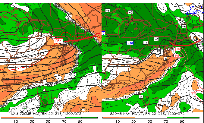
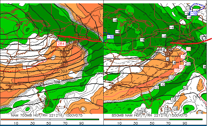
IF you want to know what to look for on other model runs to get a thump over the interior....look for the ML warm front being quite sharply defined and slowing down as it approaches us...that's when you get that really strong omega burst and it helps with dynamic cooling. We always say "look at that bent-back ML WF"....here's what the NAM looked like...left image is 700 and right image is 850 -

Preliminarily ... a medium impact partial Miller B, Friday
ORH_wxman replied to Typhoon Tip's topic in New England
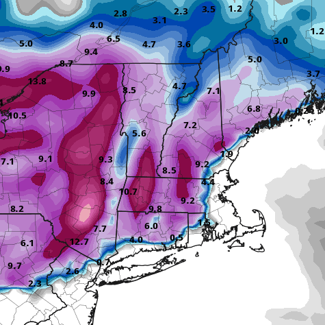
Yeah you'd prob get 10 to 1 (and maybe even slightly better if it's 31-32 with good growth) in the 1000 foot hills but I'd go 6 tor 7 to 1 in the valley on that type of look. -

Preliminarily ... a medium impact partial Miller B, Friday
ORH_wxman replied to Typhoon Tip's topic in New England
-

Preliminarily ... a medium impact partial Miller B, Friday
ORH_wxman replied to Typhoon Tip's topic in New England
East slopes of ORH hills and Berks would clean up on that type of look -

Preliminarily ... a medium impact partial Miller B, Friday
ORH_wxman replied to Typhoon Tip's topic in New England
-

Preliminarily ... a medium impact partial Miller B, Friday
ORH_wxman replied to Typhoon Tip's topic in New England
NAM looks thumpy -

Preliminarily ... a medium impact partial Miller B, Friday
ORH_wxman replied to Typhoon Tip's topic in New England
-

Preliminarily ... a medium impact partial Miller B, Friday
ORH_wxman replied to Typhoon Tip's topic in New England
Lol....maybe....or 2nd Dec '96 storm. The synoptic setup is actually not terribly different from that storm http://www.meteo.psu.edu/fxg1/NARR/1996/us1208.php -

Preliminarily ... a medium impact partial Miller B, Friday
ORH_wxman replied to Typhoon Tip's topic in New England
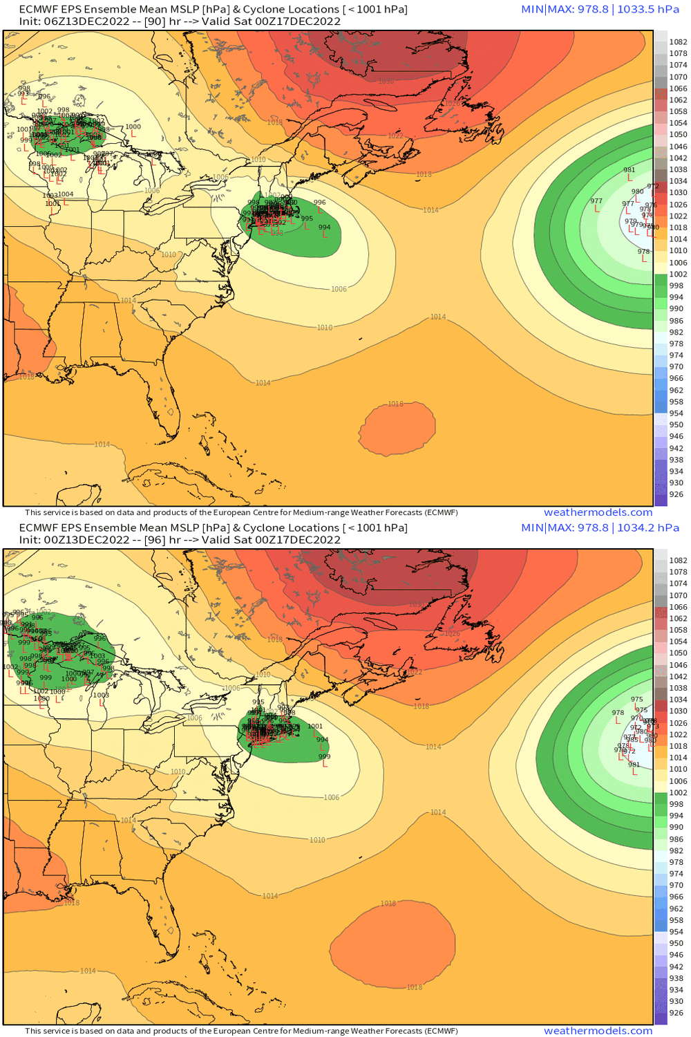
See those members that string out from like S of LI toward ACK.....if we can get those to be closer to reality, then I think ti would be game-on for ORH back into Berks and maybe even parts of 495 belt down to Kevin.....though I think those peeps would want an extra half-tick beyond that. But east-facing slopes are the place to watch on this because they will get some extra orographic assist for cooling that 900-975mb layer. I've seen it many times where it looks like it could be 37F catpaws but they slam 32-33 parachutes (think Dec 5, 2020 as one example with an even more putrid airmass than this one)....the track is still key though. In that 12/5/20 event, the track was ideal. We just had an awful airmass. In this one, the airmass is a little better but the track is still hugging a bit too close for comfort. -

Preliminarily ... a medium impact partial Miller B, Friday
ORH_wxman replied to Typhoon Tip's topic in New England
EPS came SE a bit too…these types of shifts don’t really matter for places like BOS but they do for ORH up into SW NH and perhaps even down to places like Kevin..esp if they continue another tick or two -

Preliminarily ... a medium impact partial Miller B, Friday
ORH_wxman replied to Typhoon Tip's topic in New England
06z euro came in a bit better for interior elevations. Prob some decent now for N ORH county that run.


