ORH_wxman
-
Posts
90,892 -
Joined
-
Last visited
Content Type
Profiles
Blogs
Forums
American Weather
Media Demo
Store
Gallery
Everything posted by ORH_wxman
-
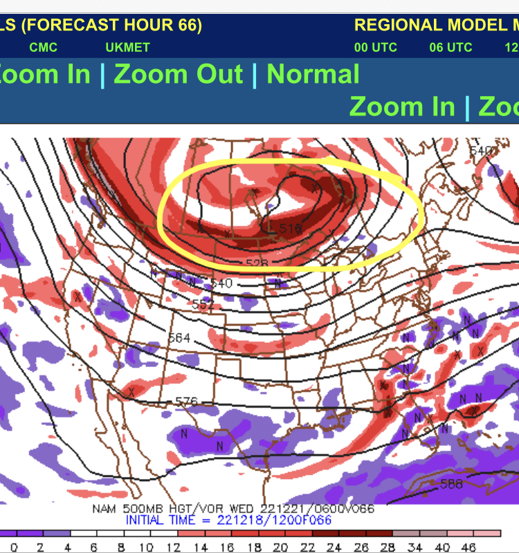
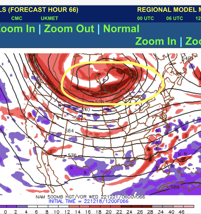
12z guidance so far is pushing more and more of the TPV lobe eastward.....it's not going to help most of us, but it will help reduce the amount of time the warm sector parks in New England....so it may be beneficial for ski areas.
-
Here's ORH top December snowfalls.....the Hudson Bay block is pretty consistent across most months. It's one reason I really liked the 12/16 look at one point when it was pushing the whole ULL under us with the big Hudson Block in place.
-
That's also a composite of all months....December is going to look different because wavelengths are a bit different....I'll see what the top December snowfall composite looks like
-
Several of the top NESIS storms missed us or just gave us a glancing blow. That looks idealized for the Mid-Atlantic. That looks pretty suppressive for New England as a whole....maybe not bad for far southern areas. When I redo the composite for top snowfalls at ORH, it def looks a little different.
-
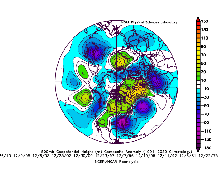
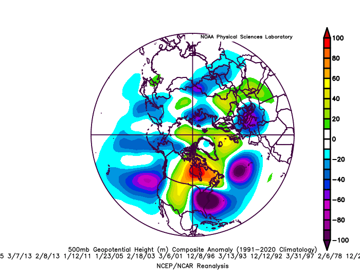
That looks too wrapped up that far west to be a KU....ULL nuclear over Detroit isn't great. On a hemispheric scale, you can see though how close we were to a great look. The longwave pattern there is excellent....but there are never any guarantees to success in favorable longwave patterns.
-
Maybe we can all lose power for a week so that we don't have to see the model solutions until early January.
-
The warmer winters from those years had really crappy patterns for the most part just like our warmest winters now have crappy patterns for the most part. Analogs are very useful. Just don’t take the temps verbatim…which you shouldn’t do anyway in analog forecasting. The anti-analog crowd has never explained how they know what a good or crappy pattern looks like…and if they cannot explain that, then they have zero ability to give an informed opinion.
-
Yeah it’s too early to punt first half of Jan. Post-Xmas looks useless though for now. Most guidance has AK pig retrograding back toward Aleutians in early January which matches some of the tropical stuff so it’s possible we get into a good pattern sometime in early January, but obviously no guarantees.
-
Ukie is actually a decent front ender…esp for CNE/NNE
-
He’s trying too hard even for his low-bar standards. Unless he’s just exponentially more ignorant than I gave him credit for back when he was nor’easter27.
-
Watch this feature (TPV)…we want it as Far East or southeast as possible…right now it kind of stalls in Ontario and then lifts back north and north west and allows the shortwave behind it to cut up to our west
-
Analogs are really to be used as probabilistic tools. I know most people just have their eyes glaze over at that term but it’s unfortunately the reality of long range forecasting. Check Jan 1969 and Feb 1969. The patterns aren’t all THAT different but the snowfall and sensible wx was extremely different….and those were one month apart…nevermind years or decades. Think of it I’m these terms: 1. pattern is really good…so we have a 40% chance of a decent snow event in the next 7-10 days 2. pattern is kind of mediocre/average. We have a 25% chance of a decent snow event in the next 7-10 days 3. pattern sucks donkey balls. We have prob a 10% chance at a decent snow event over the next 7-10 days. There are no guarantees in any of those statements. But you’d much rather have the higher percentage pattern. But if two shortwaves don’t phase properly or there’s a random over-phase and we get a cutter, then it still won’t work out. Doesn’t really change anything empirical about the longwave pattern either.
-
RGEM looks like its reverting back to parakeets if extrapolated. So we prob aren’t going to see the GGEM come east against like 00z did. OTOH, the Icon looks more interesting. Def more confluence up north this run but it’s still not quite enough.
-
A 30 hour snowfall will need to have a minimum of 2 measurements even if you are doing it the lazy way. You must measure at least once in a 24 hour period. 30 hour snowfalls aren’t that common anyway unless you live in upslope land.
-
If we didn’t use analogs, we’d be forecasting like voo-doo methods back in the early 20th century. The reason we know a western ridge is good for us is because historical analogs tell us how many large storms we got from western ridges. Are western ridges supposed to no longer good for snowfall because it was colder by 0.7C in 1975 than it is now? You can easily adjust for that too in a long range forecast….”normally I’d go -2 to -4 temperature departures but maybe I’ll go -1 to -3 instead because of underlying warming.”
-
Yeah it’s like #19 on a list of 20 things. I think many people want it to be a simplistic explanation like that but wx is way more complicated. We’ve had furnace SSTs before in December and cleaned up. An AK ridge folding over has nothing to do with George’s Bank SST anomalies.
-
Homebrew cold climo isn’t bad at least in early January. So even if Canada isn’t frigid I’d still take our chances in +PNA if we can get any sort of amplitude on that ridge. Further south you go, obviously it becomes more perilous.
-
The pattern would prob get pretty good if that low retrogrades to Aleutians like guidance is showing near the end. That’s an El Niño look…so for those wanting to flush La Niña, that’s what you should be rooting for.
-
It doesn’t make a big difference. It maybe makes a difference on the seasonal total of a couple inches here and there. The reason is because it really only matters a lot in the big double digit storms which don’t happen that frequently. Compaction rate is sort of an exponential function. So some of those big dog totals may have been higher if measured every 6 hours. However, most first order sites were already doing 6 hourly measurements even in the 1960s/1970s.
-
I think it could trend pretty decent for them in a SWFE sort of manner if they get another tick today. But can’t afford any regressions.
-
Still warm sectoring them but not as long now. Would like to see more ticks flatter today.
-
Fwiw, the 06z euro looks like it would go east a bit from 00z. It’s pressing the PV a bit further east and the trough axis a bit east as well. I still think we would need another solid tick in that direction today to make this more interesting.
-
Weve talked a lot about the younger generation being spoiled utterly rotten with snow. I don’t think anyone gets overly swayed by the argument though because it’s hard to force someone to understand experiences they weren’t a part of in-person. But if we keep up the general crappy flavor of winters that has plagued us the last few seasons for another 5-10 years then maybe they will understand a little more.
-
GGEM trying to go SWFE too.
-
We lost the PV giving us a visit. So instead of arctic hounds later this week it’s just seasonable chilly weather prior to the cutter.