ORH_wxman
-
Posts
90,902 -
Joined
-
Last visited
Content Type
Profiles
Blogs
Forums
American Weather
Media Demo
Store
Gallery
Everything posted by ORH_wxman
-
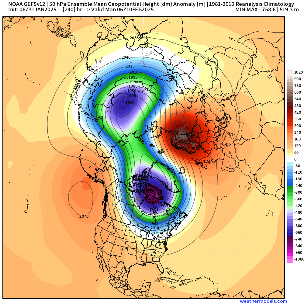
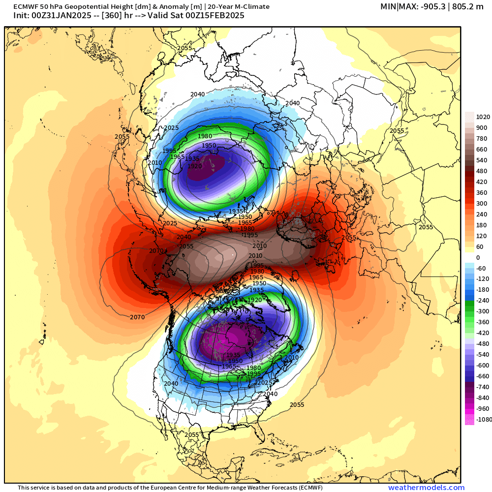
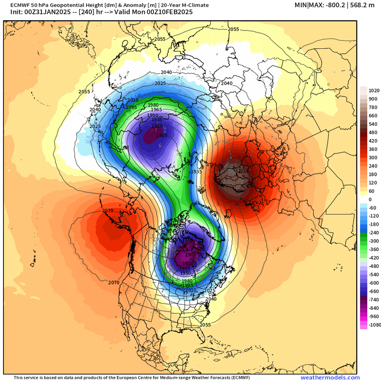
weathermodels doesn't show EPS stratosphere which is really annoying....GEFS has it though....but the GEFS signal is not quite as robust, but its def there

-
Out in clown range obviously by this point....but by the end of the run, it's obliterated

-
Euro has it splitting around 2/9-10
-
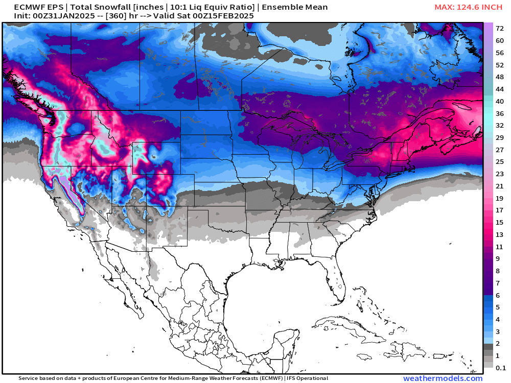
EPS has two decent signals for potential siggy snow...first one is 2/8-9 and the second is 2/13-14....the latter a much weaker signal of course considering the lead time. It's too bad we're getting a bit of a TPV lobe phase next week because otherwise, 2/5 would be a legit threat too. But I can't remember how many times I've said "too bad for a TPV lobe phasing out west" over the past 3 years.
-
You know it's exciting when half a page is taken up on a Gulf of Mexico/America discussion. On the plus side, the EPS continues to be snowier in the mean than any other time this winter....not saying I'm buying it, but I think ti speaks to the realistic potential for some good events in this upcoming pattern....as high variance/high volatility as it may be,
-
Sell....maybe up by Ray they grab a couple....I'm in the "coatings at the end" camp for the pike region....up near NH border will prob be able to squeeze out an inch or two.
-
Yeah we haven’t had a lot of that northerly flow where it just drills down the valleys of NewEngland. So much of our cold has been on west winds as the primary directional component. Lack of good snow cover over NY State and midwest helps modify that a bit but I think most of the disparity between sfc and 850 anomalies is the sun and dry adiabatic lapse rates all month like @dendrite mentioned. Typically when we have cold 850s, we’ll mix in plenty of northerly “Montreal express” flow and then also some nasty CAD type days in approaching storm systems. Those are the types of days where your high temps might offset meh low temps…like over the interior, maybe clouds kept your low temp at 13F but CAD from that approaching system keeps your high temp the next day at 18F so it’s still a nasty cold departure. Sometimes you’ll also get the scenario where the high is sitting on top of you and it’s poor mixing which makes your daytime highs much colder…we haven’t had much of that either.
-
We’ve been well below normal at 850mb this month (about -4C which converts to around -7F departure) but the sfc anomalies are very meh. Prob multiple reasons for that. Wind has kept the rad pits up. Lack of deep snow cover across a lot of the northeast and Midwest has allowed sfc to modify a bit more than maybe otherwise when these airmasses advect in. Haven’t had a lot of cloudy days with precip either on CAD type flow (northerly) which would help offset the meh low temps with very cold highs…but hasn’t worked out that way. You’re not going to convert the 850 anomaly to the sfc at a 1 to 1 ratio but we’d prob typically see more like a -2 to -4 month on those.
-
Yeah the 18z Euro was a very modest increase in precip....this is going to be like last time where the ineedsnow's of the forum claim big euro cave and in the end it will probably be far more correct than weenie GFS runs that dropped as much as half a foot of snow near the border.
-
Yes. La Niña typically has SE ridge though that has not been the case this January but it is showing up for February. Most La Niñas don’t have big coastals in February. If they occur, they usually occur earlier in the winter or later like in the month of March. But it’s not impossible…there’s been exceptions to the rule. I think the best chance of a true big dog coastal this winter will be in March. Doubly so if we get a late SSW in early February which has a chance of happening. That’s actually what happened in 2001 and 2018 which both produce huge blocking and huge coastals in March those years.
-
Yeah there's optimistic snow weenies and pessimistic ones, but they both love snow. I mean, Ji in the mid-atlantic was the biggest snow weenie for years but he was always so cynical until the snow was on his doorstep. I don't think Luke is as cynical as Ji, but just pointing out the directional similarity....you can be pessimistic and still love it.
-
I'm not getting sucked into decent rates/QPF until the Euro shows it....Euro was a big red flag last system. Doesn't have to mean it will be right this time, but I'd lean that way for now. 1-2 slushy inches near and N of border....coatings for pike region.
-
I don’t think we should blindly discount a couple super warm days though either…to the point to mocking the idea…that’s parakeets and flamingos if you end up south of that gradient. But I’ve thought for a while that it could be a lot of back and forth…we catch a warm sector (maybe), but mixed with arctic shots and probably some legit threats mixed in too. But anyone saying we’re definitely going to be cold or definitely going to torch at this point is probably full of crap…
-
Euro does have some overrunning snow/ice (eventually changes to light rain) for Feb 5-6. But it’s not a particularly juiced system.
-
Let’s lock in Feb 8-9 on Euro.
-
Euro is very weak sauce. Maybe 1-2” north of the MA border up through central NH. Ends as a coating in the pike region. Flaccid rates mostly.
-
My first winter back up here near ORH as a very young snow weenie was 1988-89…horrific for snowfall. But it was pretty cold. Awful combo. There were others before that in the ‘80s.
-
Anytime you see that large area of -20 to -30c 850 temps painted near the Canadian border, I’ve always instinctively bet against any sustained warmups. Yeah, a 65F warm sector in a cutter can def happen in these SE ridge patterns, but that authentically arctic air being so close always seems to find a way back in here fairly quickly. Unfortunately (and you already know this)…that doesn’t mean we’re gonna get a bunch of snow events either. Could just go cold—-> cutter warm sector—->arctic front….rinse and repeat.
-
Yeah not buying much down here. If we can get one more tick then maybe. I think it will change to snow but not soon enough for good accumulations.
-
Yeah we pop a western ridge in there which could get something more coastal into the picture versus overrunning/SWFE threats. We’d obviously want to see more support for that.
-
I see plenty of concerns prior to 2/10 too. That said, I’m def more “bullish” mid and late February than probably most people are.
-
We’re def getting a monster KU on like March 26th after everyone has thrown in the towel and done with winter.
-
New England Winter 2024-25 Bantering, Whining, and Sobbing Thread
ORH_wxman replied to klw's topic in New England
I remember even as recently as the 2008 ice storm the GFS had low 40s in ORH overnight between the 11th and 12th (the period when most ice accumulated)…it was ghastly. We obviously knew to ignore it back then with the mesos showing differently but it is still funny to think about. It’s def come a long way in resolving CAD. -
I don’t think anyone will care regardless if it doesn’t snow. We could get a +2 February but 25” of snow and everyone will say what a great month it was…or it could be a +1 or neutral February with 4” of snow for the month and everyone will say “see? I told you it sucked”
-
Still seems off because TT is like +1.5 to +2C warmer which is definitely not the difference between those two climo periods.