ORH_wxman
-
Posts
90,892 -
Joined
-
Last visited
Content Type
Profiles
Blogs
Forums
American Weather
Media Demo
Store
Gallery
Everything posted by ORH_wxman
-
Dude, you need to log off for like a solid week and then check back in. You’re going to drive yourself crazy searching for a winter wx event 10+ days out.
-
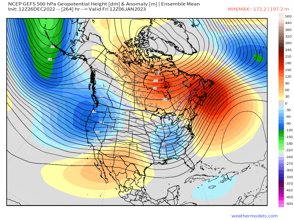
Yeah and I don’t think the pattern looks that great by 1/10 anyway on the EPS. But we’re getting close to peak climo for cold so simply moving away from an AK pig would give us some chances. GEFS looks a bit better. There will likely be changes too on the ensembles given the spread we see right now. The mean is not a high-confidence mean like we saw in the NAO block some weeks back. Ensembles were very confident in that -EPO/-NAO pattern. They are not confident at all in the 11-15 day right now.
-
Right but that just reinforces my main point…we’re essentially looking at d10-15 snowfall. Nothing before that. Any “calls” about snowfall beyond D10 should be very low confidence. It’s different than when you’re going into a favorable pattern like around d5 where you’d prob get a slew of ensemble members showing something favorable prior to d10.
-
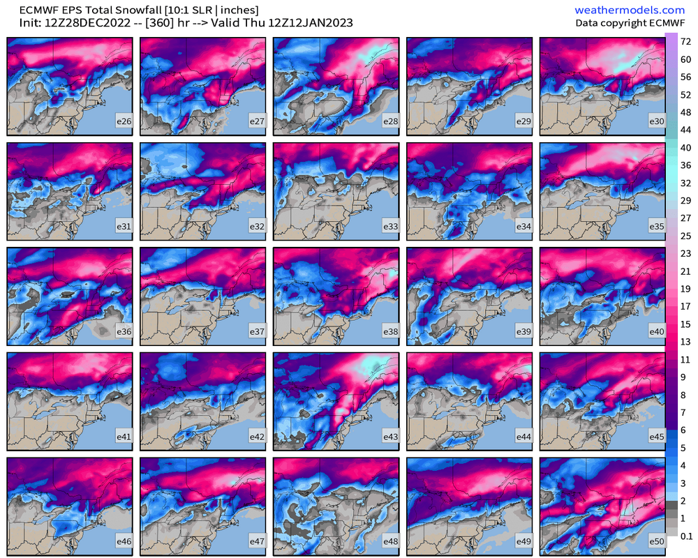
In practice, any snowfall on there south of about the VT/Canada border is prob beyond D9…so in that sense, it’s mostly long range snowfall.
-
The amount of spread on these makes it somewhat useless to try and prognosticate on snowfall.
-
EPS looked pretty bad in the D10-13 range. It got better at the very end. But there’s a ton of spread on the EPS (and the GEFS too) so it’s hard to take the LR too seriously at the moment. The tropical forcing seems to generally get more favorable as we go into January so hopefully that produces better outcomes.
-
Euro and EPS took a step toward GFS for 1/5-6. That one might be watchable. Esp for NNE but perhaps further south.
-
I don’t think I’d call it “patently false”. We had a vortex over the Davis Strait and Baffin regions. Maybe for the Feb 2nd event there was some ridging poking up toward Greeland that helped redevelop that SWFE into a coastal The crazy success of that 3 week period was due to a nearly “standing wave” ideal PNA ridge out west…and the one time it broke down a bit in the Feb 7-11 window, we had well-timed Scooter streak to keep us north of the boundary and we got a 3 day overrunning event that dumped 2 feet in BOS
-
He just makes shit up. Don’t treat his posts as anything other than unserious clutter.
-
Dec 2017/early Jan 2018 was mostly PAC-driven too.
-
Same general mechanism that produces the snow/ice on the GFS for 1/6. GEM actually presses the TPV lobe a little too much.
-
You must have been under a rock in 2013-2014 and 2014-2015.
-
Really the earliest chance for anything would prob be around 1/6-1/7…so we snooze for now. There’s so much spread on the state of the PAC, I’m not going to get too invested in trying to analyze the guidance. There’s still a generally improving look in the tropics so I’m cautiously optimistic the deeper we get into January but there’s far from any guarantees.
-
‘12-13 too for coastal areas (interior had some good events prior) But those years weren’t Ninas. Gotta hope for a year like ‘55-56 or ‘00-01 in the second half if we’re gonna do it in a Niña. The one positive we have going is the huge blocking that already showed up. Those types of blocking episodes tend to be a harbinger of future blocking later that same winter. Not always but more often than not. I’m not seeing much blocking though returning yet on guidance. Mostly just the PNA turning positive.
-
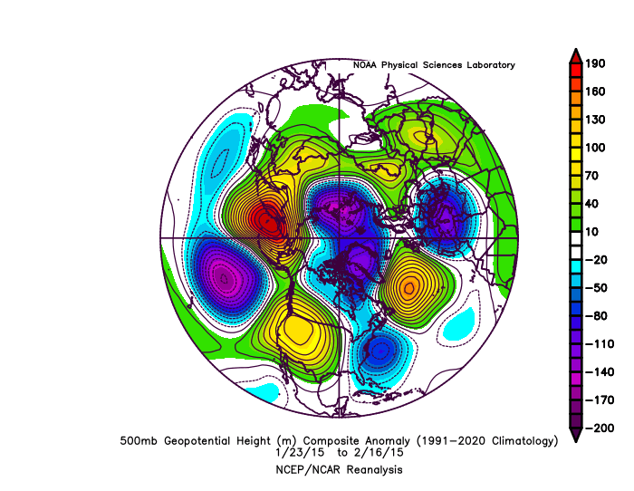
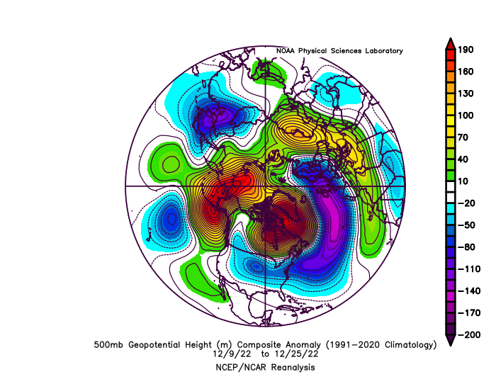
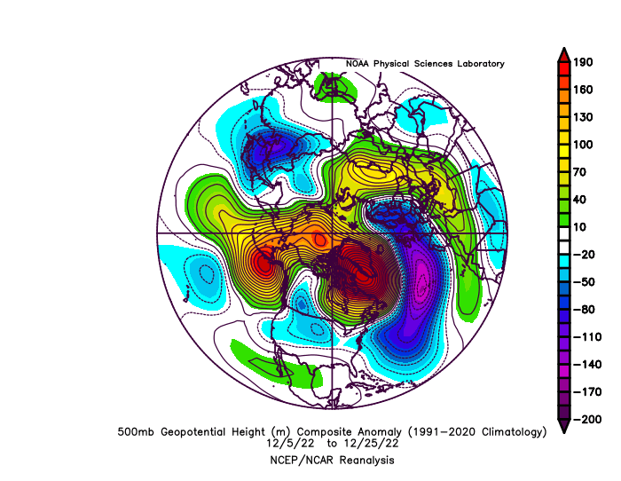
Those h5 maps above are a great illustration of how the ensembles actually did predict the mean pattern fairly well, but the smaller scale features within the mean pattern mostly broke against us and those smaller scale nuances are not easily predictable at 1-2 weeks notice.
-
And if you get rid of the transition period between 12/5 and 12/8, it looks even more classic
-
This is the last 3 weeks mean pattern. Hard to believe we didn’t do better. NNE didn’t do too bad…so much for fearing suppression.
-
His posts aren’t serious and shouldn’t be considered so.
-
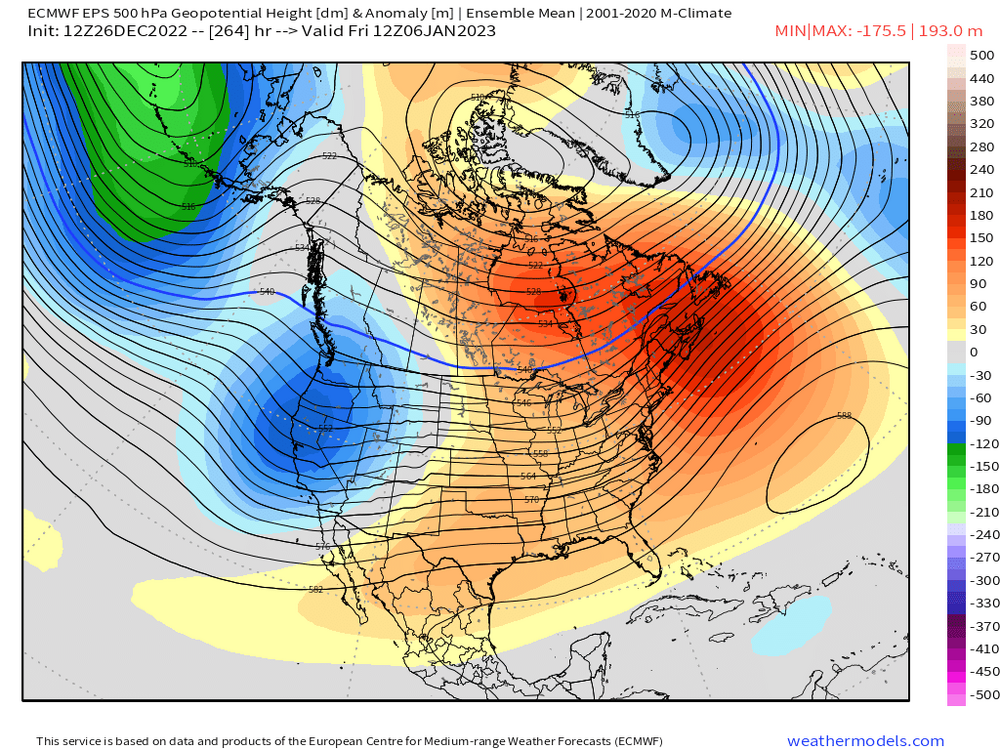
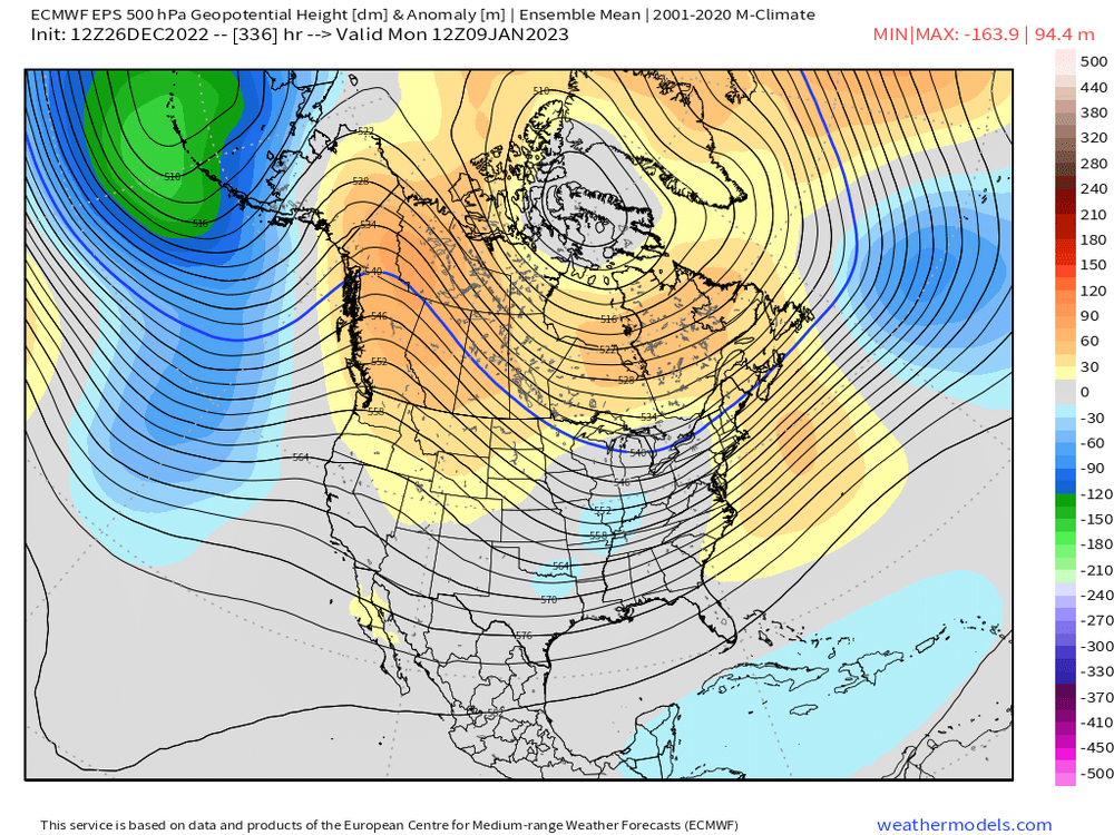
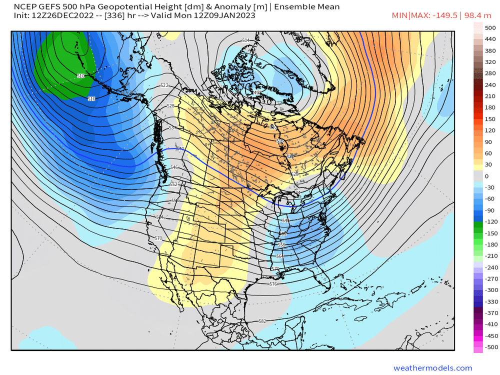
I feel like the GEFS actually change the pattern earlier than the EPS but it just never gets as favorable as the EPS. Like here’s D11…EPS looks worse than GEFS here: But by the time we get to D13-14, the EPS looks a lot better in the PAC but I’d don’t really hate either look:

-
Energy policy has been embarrassing for a while now. We’ve made voluntary decisions to move away from nuclear (an excellent bridge energy source between fossil fuels and renewables), we’ve hindered the natural gas infrastructure which actually increases the use of oil and coal in the short term (see the nixing of natural gas conversions away from heating oil all across New England because we cannot pipe nat gas in from PA), and we’ve had a lot of NIMBY problems updating the grid itself to be less susceptible to weather (such as putting lines underground). It’s unfortunate that everything becomes so political that it’s hard to navigate our way through all of it with logic, but that’s the reality we live in today.
-
Yeah and we’re prob waiting longer in SNE. At least the pattern change is moving forward on the ensembles. We’re not yet seeing it get pushed back which is about all you can ask for at the moment. Hopefully that doesn’t change but it’s always a possibility.
-
“Recorded” means since official measurements were taken. Though we know by proxy that it hasn’t been this warm for a long time….certainly the past 1100-1200 years and possibly not since the early Holocene. I don’t have an issue with the temperature claims. Biggest problem with those articles is the attribution dialogue. They get so many things wrong too often (such as the incorrect relationship they stated between hurricanes and El Niño) that it renders the article mostly worthless.
-
This is why you got a bunch of shit. If your vacation was next weekend, you’d have legit concern. But you’re not going for almost 4 weeks…NNE might be buried by then. Honestly, if I was you worrying whether my wife would have a good experience, I’d be more worried about bitter cold temps in mid/late January than snow conditions. Nothing ruins a ski experience like bitter cold that you might be slightly underdressed for.
-
I could see 1/5-6 being more interesting for NNE and perhaps down into interior SNE if we get a bit more compression up north as Tip mentioned. Longwave pattern though becomes more favorable a few days beyond that.
-
Yes we will want to do anything to disturb the “base climo” of La Niña in the 2nd half of winter.