ORH_wxman
-
Posts
90,892 -
Joined
-
Last visited
Content Type
Profiles
Blogs
Forums
American Weather
Media Demo
Store
Gallery
Everything posted by ORH_wxman
-
'83 was a super Nino....the pattern is definitely like that for a couple weeks here. About 4 days before the big KU, there was another big storm that hit interior SNE hard, but the coast had a lot of ptype issues.
-
The bolded is a good thing on a scientific forum....people should be exposed to heterodox opinions as long as those opinions are in good faith and backed with evidence. I think when evidence-free claims are made, that's when people perceive it as trolling and they are often correct.
-
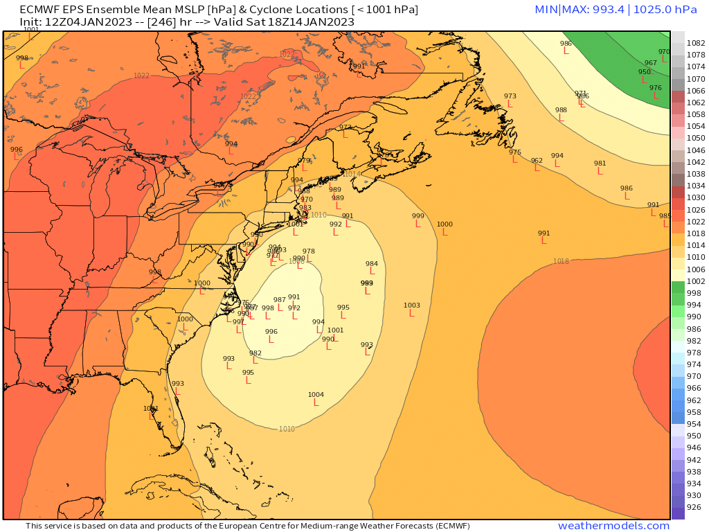
Quite the spread on the EPS between Maine and the SE coast, but it's a strong sig. Can't say much else at this point

-
Also, we typically have at least a few threats kind of show up out of nowhere inside of 5 days every winter but that hasn't really happened this year. Those "surprise" threats typically take our attention away from clown range. Probably 12/11 is the only one that really ramped up inside of 72-84 hours this season and even that one was mostly a clipper-esque system that got western SNE the best.
-
I'm not sure what people are supposed to do on a weather discussion forum though.... How many times have we said a severe setup looks "interesting" but then we get a couple pulsers and that's it? Prob like 100s in the last decade and a half. But that's what we do....we look for potential understanding that a lot of times, the potential never materializes into sensible wx. If the potential always materialized, big storms or big severe outbreaks wouldn't be that exciting.
-
Gonna be squashed....too much confluence from the TPV lobe. But 9-10 days out.....caveats as usual.
-
Get mostly shunted south this run
-
Gets pinched a bit south as trough narrows....but at this lead time, def still very much on the radar. That SPV extension has been trending SW on the Euro steadily though. It's an interesting trend not just for the 12th if that storm even happens....but for the 14th....it probably sets the stage with a fresher antecedent airmass.
-
Yeah the 9th doesn't look all that impressive....it's been on a lot of runs bit I would be surprised if anyone saw more than advisory amounts from that. Decent chance it's mostly nothing too. Doesn't seem to have a lot of dynamics with it and airmass is marginal. Still worth watching though. But the higher end potential is definitely with the two waves after the 9th.
-
I was just recalling how brutally cold that month was and then I was thinking how funny it was that February 2015 was like a full 1.5F colder than Jan 1994, lol. Not for temp departure either....raw temp average. Jan '94 had 7 sub-20F high temps.....Feb '15 had 9 of them (in a month that is harder to get them too). Each month had 10 days of 0F lows or colder. Of course, Feb '15 easily takes the cake for snowfall....lol
-
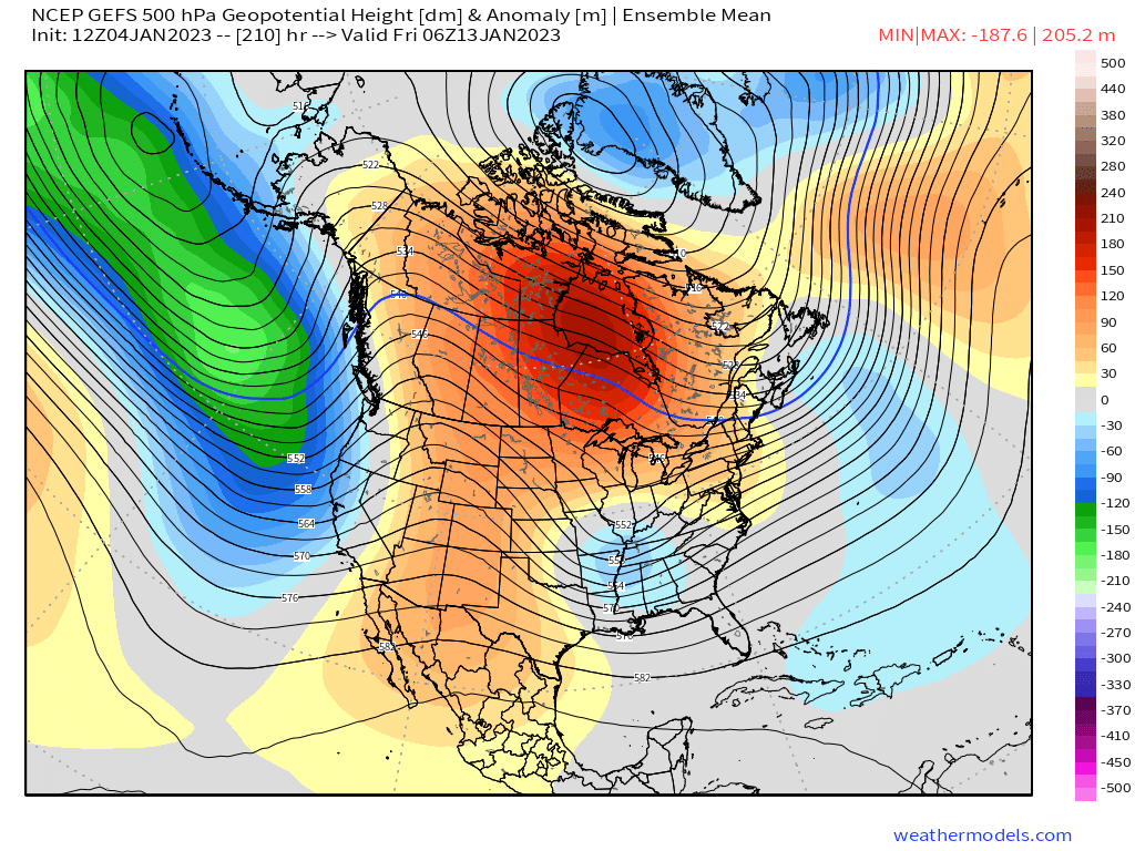
From a purely synoptic standpoint, the GEFS look pretty classic for 1/14....you have your ideal ridge placement over the Rockies...shortwave undercutting the split-flow ridge in Canada and confluence in SE Canada. Miles to go, but at this lead time, that's all you can ask for.

-
Nice scooter high for the 1/14 threat.
-
GEFS also has the Jan 11-12 signal....but obviously not full-on crazy like the OP run....

-
Yeah only thing that kept it from being a top 3 alltimer for me was the big thaw in February and maybe that we didn't get a true top end storm....it was still a grade A winter though. The brutal cold day after day in January with deep snow pack was a caricature of deep winter....it was great.
-
Yeah we used to have 510 thicknesses with storms hitting Bermuda on every GFS run beyond 240 hours....now it only gives us unphased fish storms when it's like 3 days before a KU.
-
Goofus doesn't look terrible either...maybe just a shade warm but close.
-
Man, that's a full-blown El Nino pattern on the GFS in clown range. Pretty weird to see in a La Nina.
-
When the hell is the GFS doing for 1/11-12....looks like it's trying to reincarnate a mini-1888 with vertical front slicing the region by longitude.
-
Decent amount of sleet in your hood in Jan 94 too which also kept the snow totals down just a bit. I had closer to 3 feet that month....plus a good amount of icing on the front end of both cutters.
-
GFS looking a bit healthier for 1/9....still mostly just scraping, but that is pretty close to being something quite a bit better.
-
What an awful forecast by the euro from like 24 hours ago.
-
RGEM actually has a nice burst of snow over the interior of MA and maybe into N CT for Friday...prob like 2-3" in higher terrain and maybe an inch or two lower down. It's all associated with the ULL vortmax swinging through, so it's one of those things that probably won't show up on every model and every cycle....you'll just have to watch it.
-
Lucked out there....full on wedge here....it will eventually overcome you later today, so enjoy it now.
-
This one is pretty underrated too...gets overshadowed by the blizzard a few days later, but I had like 14-15" from this one: http://www.meteo.psu.edu/fxg1/NARR/1996/us0103.php http://www.meteo.psu.edu/fxg1/NARR/1996/us0104.php That's a man high.
-
Gonna have to watch for a bit of tuck action Thursday night over eastern areas....only takes it getting to like 30-31F to get nasty pretty quick if there's some light precip lingering.