ORH_wxman
-
Posts
90,892 -
Joined
-
Last visited
Content Type
Profiles
Blogs
Forums
American Weather
Media Demo
Store
Gallery
Everything posted by ORH_wxman
-
Yeah, like the Herpes is compared to the RGEM. Maybe we'll get an obscene 3k solution at 00z tonight.
-
Here's the individual members as it makes the closest pass to the benchmark....we're a long ways out so this doesn't mean a whole lot yet. Unfortunately, I feel like it has to keep being said about D9 progs lest you be accused of implying these are going to verify verbatim (which is kind of impossible when we're posting an ensemble spread....but logic never got in the way of a good internet meme argument).
-
It's not very juicy compared to those other meso runs. It's basically like 2 tenths of QPF here while others are at least double that. But we know that's part of the deal in this...if the precip is lighter, it's going to make it much more elevation dependent and warmer sfc temps. If it rips, then it will accumulate regardless.
-
NAM gone wild
-
Do you remember this event? It was like a 2-4/3-5 forecast and ended up as a 5-9" high end bust away from immediate water....but even BOS had like 3" when they weren;t forecasted to get much of anything. Your injection low comment reminded me of it....that was def an injection low. Dynamics were better for that one so i dont expect the same insanity, but a surprise high end advisory event isn't out of the question
-
That was super close to being an epic solution....we want to see more northern stream injection of energy i think on future runs which will help the southern stream not bury itself too far south before trying to turn the corner....we want a bit more of a phase I think. But 9+ days out...hopefully it looks good 4 days from now.
-
Nah, they'll whine about a miss SE instead of the GFS cutoff rainstorm.
-
I'd like to see a little more northern stream injection on that....we don't want this cutting off too early from the flow. Thankfully, it's trying to inject N stream there on that frame...but I'm hoping future runs are a little more aggressive with it.
-
PH value and crystalline structures are recorded in the log book.
-
Yeah I don't think any model would give him under 2". Euro was closer to 4" though and so was the 12z NAM....but the NAM was better than the Euro for down in SNE.
-
Or Herpes/RGEM.... Heck, I'll take the GFS too or Ukie...they all looked pretty good. Euro was the usual turd in the punch bowl, but lets see if it does the typical Euro sleaze and slowly ramps it up at 18z and 00z on the rates...or if it scores a coup
-
Euro least impressive of all the 12z guidance. Although maybe it;s just doing the usual "I don't want to make a huge jump in one cycle" thing that it loves to do....because Euro was also the least impressive on almost every previous run too but it's been slowly juicing up.
-
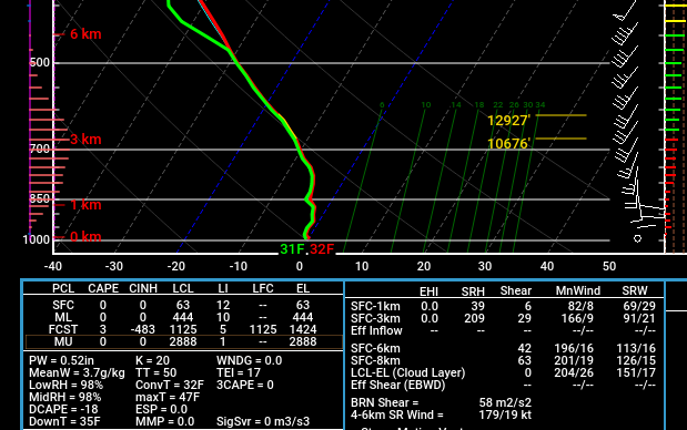
Soundings are pretty unstable....here is ORH tomorrow on the NAM around midday
-
He already said basically nothing outside of the hills before we moved to this thread. BL too warm.
-
BOS hasn't had a 1" event though yet....0.9" and a 0.1"....1.0 total, lol. They have a decent chance to get an inch tomorrow though.
-
To answer his question though....I think the latest was 2007 when it took until Feb 14th for the first event of an inch or more (cumulative first inch happened in January that year).
-
So you admit you never use ensemble guidance? Just trying to clarify.
-
My biggest "worry" from a forecasting perspective on bust potential is the IVT/norlun look prolongs the heavier snow over central/eastern areas for 3-4 hours tomorrow evening. That could turn a 2-3" event into a 6er. The lower end bust potential will be if the BL has trouble cooling (esp lower elevations...don't think this will apply for higher terrain)....but if we're ripping 20-30 microbars in the DGZ, I have a hard time believing even the coastal plain doesn't flip to moderate/heavy snow for a time.
-
I’m hoping my little bit of weenie elevation being out near 495 will do the trick. And yes, I think for ORH county and other elevated areas, it will prob be close to 10 to 1 ratios because it’s going to be good snow growth I think. A little trickier lower down but if you dynamically cool to 32F, then ratios will be closer to 10 to 1 when that happens or maybe even a little higher….but during the 34F SN- periods it will be 5 to 1 slop.
-
That's a pretty good BOX AFD that covers the specifics. The potential for a heavier burst is where the biggest bust potential lies. IF we get 4 or 5 hours of heavier snow, then it's going to be a positive bust with some 4-6" lollis....but if it stays mostly light, then it will be a general C-2" type deal with maybe a 3"+ lolli or two in the highest terrain.
-
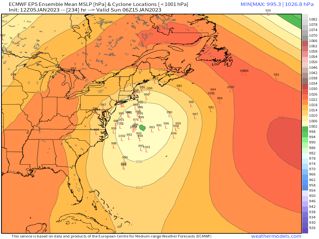
Ya'll are gonna drive yourself nuts looking at OP runs 200 hours out....Euro has like -20C 850 temps over SNE at 200 hours last night and the entire system gets shoved out to sea. If the storm gets completely cut off from the rest of the polar jet, then yeah, you're gonna have a springtime look to it but I'd probably wait until we're a little closer to start your whine and cheese party all over again
-
Wouldn’t be surprised if advisories go up for interior if euro mostly agrees with the 12z guidance so far. But the 00z and 06z runs weren’t that impressive so it needs to ramp up a little from those solutions.
-
Wow 12z GFS is really impressive for tomorrow over interior.
-
Yeah if you had one of those Pineapple Express Ninos. But not all of them are that far south. We’ve had some that are a little further north too.
-
It was the next day that pushed you over the edge. You were already furious about the pics of Megan and I walking through the woods with 8” of paste and then the next day we had that little impulse come through and we got hit with a surprise 4” while you were pouring rain. I posted the pics below and then you just went on an all time melt…it was probably better than my melt at the ecmwf.int folks