

ORH_wxman
-
Posts
93,095 -
Joined
-
Last visited
Content Type
Profiles
Blogs
Forums
American Weather
Media Demo
Store
Gallery
Everything posted by ORH_wxman
-
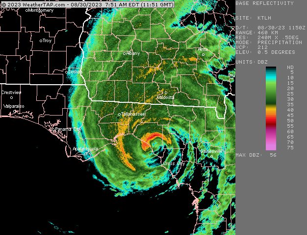
74 knot (85mph) gust at Perry airport KFPY 301215Z AUTO 01054G74KT 1SM +TSRA OVC008 25/24 A2828 RMK AO2 LTG DSNT N AND NE P0029 T02470240
-
I heard from him about 45 min ago....said he was losing signal. The strongest part of the eyewall looks like its going to go right over him in Perry, FL....ironically the strongest part of the eyewall in this storm was the NW side.
-
Yeah…Pinatubo was the most climate-altering eruption since probably Tambora in 1815. The 1912 eruption in Alaska was bigger but not in the best spot to affect the global climate.
-
Looks like the 12z hurricane model guidance shifted back east a little from 06z late run....more in line with the 00z forecast
-
That has to be near record territory. You're not even right near Philly....inland north of Lancaster seems like getting less than an inch is record material....I wonder how much they got in '72-'73 or '97-'98.
-
Snowfall has significantly increased in New England as we've gotten warmer. There is an eventual threshold where that stops happening, but don't exactly know where that number is. We do have some unique geography that helps with snow and so far, the increase in moisture has outweighed the warming temperatures. Places like interior Northern New England likely will never see big snowfall decreases because the warming wont be enough up there even through the end of the century. But SNE could...it remains to be seen. There's also plenty of natural variation on top of underlying warming....we have had pretty warm/snowless periods a long time ago too (think of some periods in 1930s and esp late 1940s/early1950s)...so that is why we try and use longer periods than just a few years to determine whether there's more permanent change....but that is hard this day and age with people wanting to link short term weather events or seasonal numbers to climate change. A lot of these fluctuations are due to larger scale pattern variability like the AO/NAO. We saw this even back in the early 2000s when we had been on a long-ish run of +NAO winters going back to the 1980s....they all said climate change was responsible for the +NAOs.....then all of the sudden right when they published a lot of those papers, the NAO started going more negative culminating in the very negative period from 2009-2013 which prompted a whole new set of papers that claimed lower sea ice was actually responsible for the more frequent -NAO patterns....then of course, the NAO started going more positive again after that, which shows that some of these things are bit too stochastic to be making pronouncements about on short term trends.
-
Why?
-
2015 will be known as "2024-lite" when we're done.
-
In our best month? Sure, why not. Strong Nino STJ juiced with a big PNA this winter....
-
That dataset has been around for years....and they haven't fixed December yet. Every December reading is corrupted as -99.9 The other months are good though....one caveat on this dataset though is that the EP/NP has the opposite sign of the traditional EPO index. So a positive EP/NP here means a negative EPO (i.e, check those frigid months like Jan 1994 and Feb 2015 which had huge -EPOs....they are huge positive numbers on this dataset). So just as long as people remember that when looking at the values.
-
NSIDC area is currently at 3.34 million sq km. This is 110k higher than the to-date min on 8/18 of 3.23 million sq km. It is highly unlikely we've reached the min that early as it would break the record for earliest minimum by 11 days. There's still a shot we can sneak into a top 5 melt season, but it needs to pick back up soon.
-
Winter 2023-2024
ORH_wxman replied to Stormchaserchuck1's topic in Weather Forecasting and Discussion
A bunch of seasonal forecasts went bullish for cold/snow in 2001-02 and of course that caused quite a lot of mea culpas and it likely caused the '02-'03 forecasts the next season to be much more conservative in the aggregate. Back then, the tools weren't nearly as plentiful as now, but ENSO was still a huge consideration in most forecasts. -
Winter 2023-2024
ORH_wxman replied to Stormchaserchuck1's topic in Weather Forecasting and Discussion
So was 1925-26. -
Looks like it weakened some. Prob not gonna get much wind.
-
Some decent rotation just SW of me now. Wonder if that will tighten up a bit more.
-
About to get crushed here
-
gracias amigo
-
I lost the link to the RAOB records....what are the coldest readings at GYX in August for 850mb? IIRC, late August 1986 had a brutal cold shot where 0C 850s got down to ORH-BOS
-
I was in Dubai in 2014 and it's gross there. It's humid in the low levels but with a ridiculous cap so you get no convection. I think we had a reading of 105/83 at one point without a cloud in the sky.
-
Yeah that is a brutal white faced hornets nest in that pile. My guess is several hundred hornets at minimum based on the frequency of the traffic in and out of the nest. Dig into that wood pile on a 20F November morning and see how big the nest remnants are.
-
Condolences @dryslot Hopefully you're hunting big game still at 91....carry on his legacy.
-
We've had a ton this summer in the woods behind my house....definitely more than I normally see in the summer. Usually I see them more in winter because it's easier to spot them with no foliage/undergrowth. But this summer, I've glanced into the woods many times and saw them moving. Also on a brighter note, the yellowjackets this summer have seen quite a bit fewer than normal. I'm wondering if some of the ground nests got flooded out during the heavier rain events. I'm sure I'll step on a nest in September now that I said this.
-
Wonder if the hottest temps of the year are going to end up being that mid-April hot spell. Many stations haven't beat that yet.
-
That would loosely fit with winters like '57-'58 and '65-'66.
-
I'm a little concerned about a roaring PAC STJ sort of juicing up with the PJ off the west coast. Some of the seasonal guidance tries to show this. I only said I'm a little bit skeptical of a big winter....not that the winter will be a full ratter. If we got something a little better than '97-'98, it would be a decent winter in New England (different story further south). That said, if we continue to see no sign of forcing migrating eastward into the autumn, then I'd start getting more optimistic for something bigger this winter. A juiced PAC jet with forcing near the dateline with modest blocking would be pretty awesome to roll the dice on here.


