ORH_wxman
-
Posts
93,093 -
Joined
-
Last visited
Content Type
Profiles
Blogs
Forums
American Weather
Media Demo
Store
Gallery
Everything posted by ORH_wxman
-
Octorcher or Roctober 2023 Discussion Thread
ORH_wxman replied to Damage In Tolland's topic in New England
For SNE, every single winter between 1984-85 and 1991-92 was drier than normal except the '86-'87 winter. -
Octorcher or Roctober 2023 Discussion Thread
ORH_wxman replied to Damage In Tolland's topic in New England
Yeah for many of us the 1980s reference is really mostly after the 83-84 winter through the 1991-92 winter which is something we should specify more often since any normal person would look at the entire decade....86-87 was spectacular over the interior (though I missed the majority of that one living in Texas at the time)....and '87-'88 was serviceable. But the defining feature of the mid 1980s through early 1990s was the lack of blockbuster periods or winters to offset the absolute turds. '86-'87 was really the exception (and mostly January 1987 at that). Of course, anyone who is very familiar with SNE first order climo knows also about the 10 year streak where Boston failed to record a 12"+ snowstorm....a stretch that started after the February 1983 KU event and ended with the March 1993 Superstorm. That brutal period also includes the only time that ORH did not record a 10"+ storm in 3 consecutive winters....and they actually managed to do it for 4 in a row ('88-'89 through '91-'92) just to make sure we all knew. -
The only time we had MJO forcing in the 8/1/2 regions last season was the second and third weeks of March.
-
Octorcher or Roctober 2023 Discussion Thread
ORH_wxman replied to Damage In Tolland's topic in New England
We often joke in here that rainy cutters followed by a frigid blast is a "1980s pattern"....those of us snow lovers who grew up with that remember all too well and not in a good way. -
Octorcher or Roctober 2023 Discussion Thread
ORH_wxman replied to Damage In Tolland's topic in New England
The irony is that Nov 2002 had some really cold periods because the tropical forcing went La Nina for a while. When I say "La Nina", I mean the typical phases we might see in mid-winter during La Nina. Those phases are usually warm in mid-winter, but they are cold in November (esp early/mid November) La Nina forcing is what also aided the frigid cold and multiple snow events in mid-November 1986. If you want to maximize the cold, then we'd prob want MJO in the "warmer" winter phases in November which tend to be colder that month as explained above, and then return to the 8/1/2 phases in December, which often happens in real La Ninas...that's why many LA Ninas like 2007 or 2017 have cold Decembers....because the forcing tends to go 8/1/2 in December La Nina a bit more frequently. El Nino is usually the opposite....crap phases like 4/5/6 in December and then it goes full winter as we go deeper into winter. Now tropical forcing isn't everything....we can be cold even when tropical forcing kind of sucks....but it usually takes something to overwhelm it like exotic blocking. -
Octorcher or Roctober 2023 Discussion Thread
ORH_wxman replied to Damage In Tolland's topic in New England
Looks like the MJO is kind of rotting near the phase 8/1 line as we go into November....that's actually a semi-mild composite for November despite being a very cold look in Dec/Jan....so I'm fine with it. That's where we want the tropical forcing to set up going into winter. -
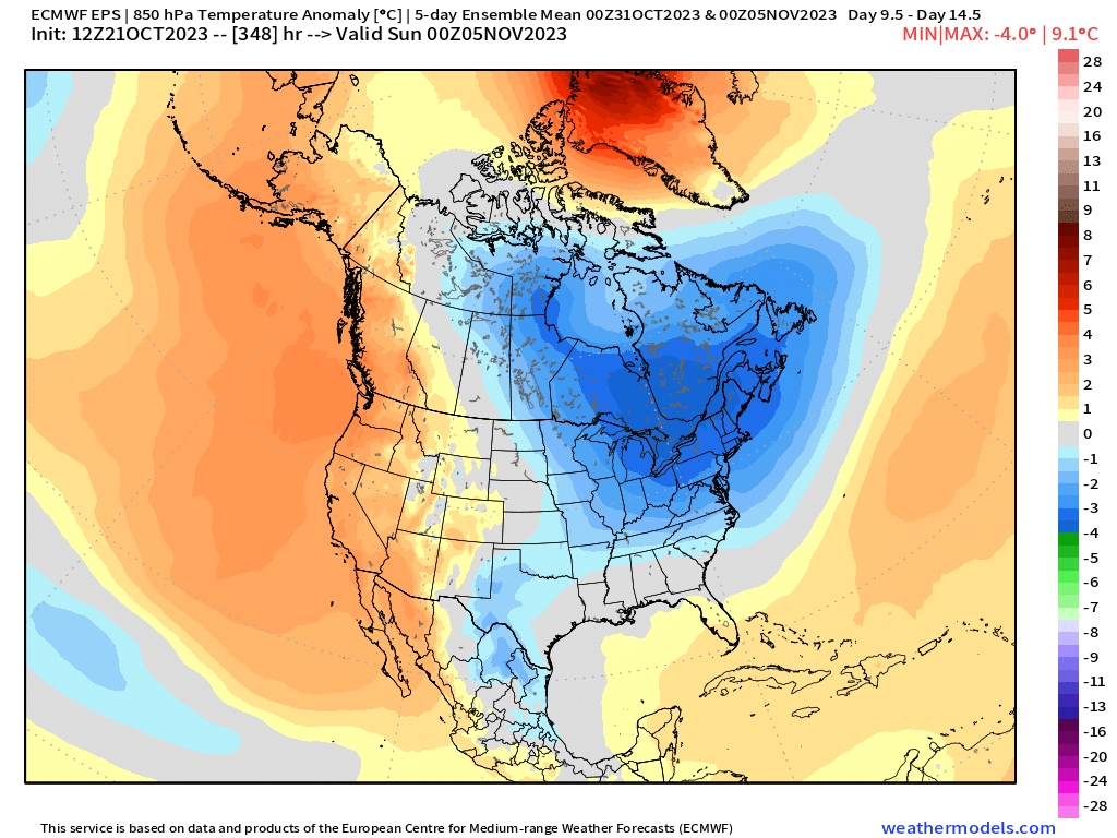
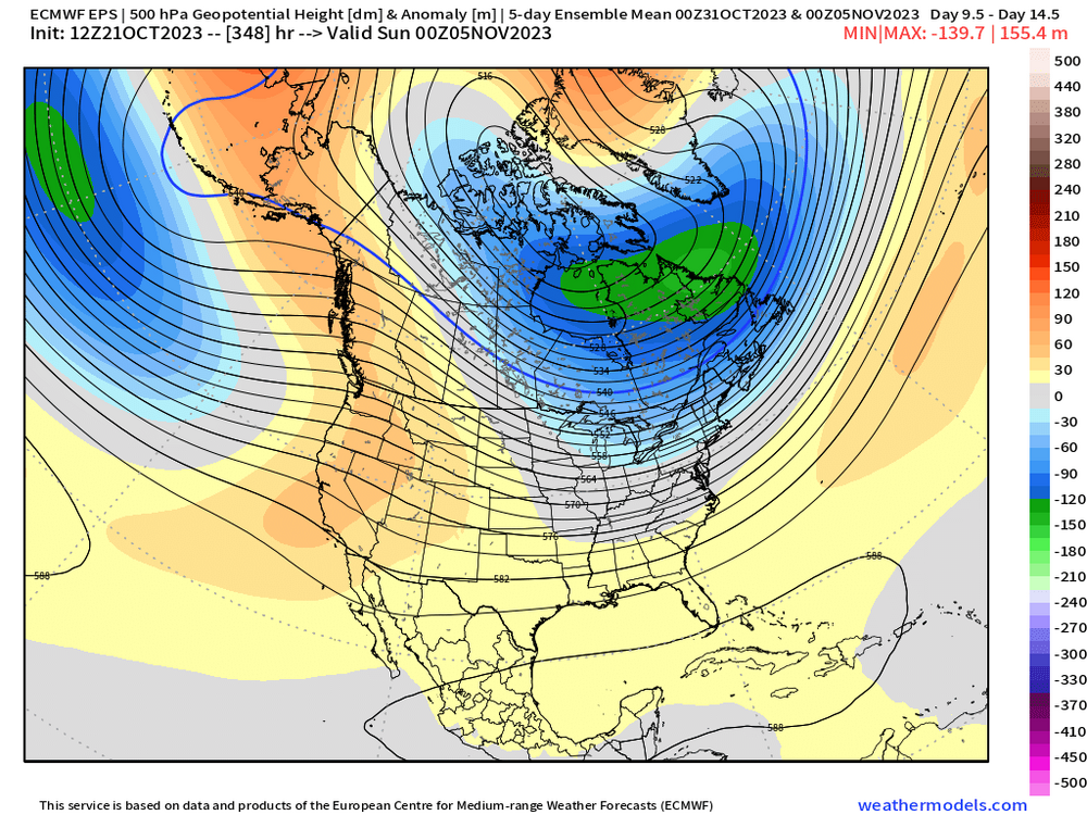
I’m not Tip but I’ll pinch hit for him on this one…first H5 anomaly (5 day average mean ending 11/5) and then 850 anomaly for the same period… At the moment, ensembles are keeping the cold relatively transient…lifting it out by the very end of their ensemble runs, but we know the caveats sometimes when changing into a new pattern…sometimes guidance tries to end it too quickly. So we’ll see how it all shakes out. But definitely a colder look coming in around Halloween into early Nov
-
Octorcher or Roctober 2023 Discussion Thread
ORH_wxman replied to Damage In Tolland's topic in New England
Pretty common for your area just west of the ORH hills spine to see first flakes on our first big cold shot on a longwave setup like a lot of ensembles are showing. That area tends to get some rotting flurries or snow showers from any dying LES that survive over the Berkshires…and then they usually dry up completely before reaching further east unless there’s a disturbance aloft to keep them going. -
Octorcher or Roctober 2023 Discussion Thread
ORH_wxman replied to Damage In Tolland's topic in New England
Yeah I mean we’ve had some ugly rainers recently in those awful Cabo San Lucas troughs but a canonical warmish pattern with decent precip will usually be plenty of snow up there. Even here we can go pretty snowy in a warm/wet winter. -
Octorcher or Roctober 2023 Discussion Thread
ORH_wxman replied to Damage In Tolland's topic in New England
Yeah. Actually looks an awful lot like 10/10/79…with that wave developing along the frontal boundary. Regardless, EPS is really hitting the cold hard on todays 12z run for Halloween and just afterward. -
If we’re parsing like 1.9 vs 2.0 then it’s completely trivial…but the difference between something like 1.7 and 2.2 would be noticeable for sure. I’m becoming skeptical this will act like a typical Super Nino anyway though even if we squeak over 2.0 ONI because the MEI is lagging so much.
-
Octorcher or Roctober 2023 Discussion Thread
ORH_wxman replied to Damage In Tolland's topic in New England
Been a while since we had consistent N PAC look like that with the decent western ridge. I expect just a cold shot out of the general longwave look, but we obviously know that snow can happen that time of the year even if not all that frequently.
-
Yes agreed....it's why so many here often hear us say "the cold may initially dump into the plains/rockies but could ooze over the top before we get more established cold X days later".....when the cold leaks over the top before the motherload later on, that's frequently an opportunity for an overrunning/gradient type event....
-
Octorcher or Roctober 2023 Discussion Thread
ORH_wxman replied to Damage In Tolland's topic in New England
Does it count as a town if nobody lives there? 510 thicknesses would be extremely impressive for first few days of November....doubt it's that extreme, but there's pretty good ensemble support of a decent cold shot as of now. Would be good to kill off the rest of the yellowjackets at least. -
Octorcher or Roctober 2023 Discussion Thread
ORH_wxman replied to Damage In Tolland's topic in New England
What town? Dude lives in the middle of nowhere, lol. -
Octorcher or Roctober 2023 Discussion Thread
ORH_wxman replied to Damage In Tolland's topic in New England
Men in thy knickers screaming about a volatile climate.... -
Octorcher or Roctober 2023 Discussion Thread
ORH_wxman replied to Damage In Tolland's topic in New England
I love how they flirted with 0F on 11/5 and then hit 72F 10 days later. -
Octorcher or Roctober 2023 Discussion Thread
ORH_wxman replied to Damage In Tolland's topic in New England
Yeah there's definitely a weakness in the snowfall that shows up on the daily records for ORH (and by extension that would include most other interior SNE sites) in early November....really the first 5 days of the month...and late October has a lot of days that beat those first 5 November days.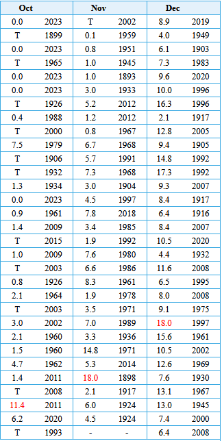
-
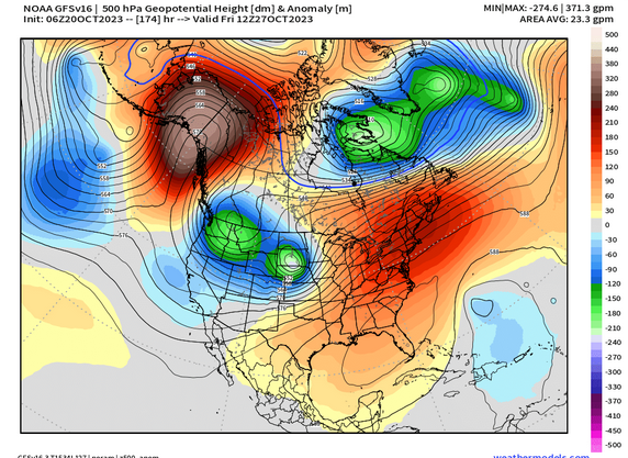
It's a fairly common pattern when you get a -EPO block that kind of folds over....but the placement of these features would probably be a bit different int he winter with extended wavelengths. We'd prob see more of an Aleutian ridge poking into AK from further west than we see here to get that negative height response in the PAC NW. If you had an Aleutian low with a -EPO in winter, all of that response to the east would look different than it does here in October. You prob have the lower height response occur much further east. This is all speculative anyway. Who knows what the N PAC will look like in winter...but I'd be surprised if we got a lot of -PNA patterns this winter. I'd expect -PNA patterns with this strength of El Nino to be transitory.
-
There's a vortex over the Davis Strait though....that's the opposite of the December blocking episode last year. There's also a weak Aleutian low in the N PAC....opposite of the ridge last year. Longer wavelengths in winter prob is a lot colder look
-
Octorcher or Roctober 2023 Discussion Thread
ORH_wxman replied to Damage In Tolland's topic in New England
Narrowly missed snow in 2014....I think that was the day Blue Hill got a couple inches but west of Rt 128 didn't get much of anything. -
The Modoki index just tells you how west or east based the ENSO event is....so they are calling for a Modoki index of +0.4 which is a somewhat neutral number....basically basin-wide.
-
It will also be interesting to see how the pattern actually sets up versus the sensible wx results....95-99% of the population will only care about the sensible wx results, but I'll definitely be interested in how we got there. For example, what if we torch this winter but it's because of a La Nina-ish -PNA pattern in tandem with a +AO/NAO (think 2011-12).....a lot of the Super Nino fetishists will start screaming "seeee!!!11!! told ya it would be a torch!!11!" but the irony would be that it wasn't for remotely the reasons they were expecting.
-
Yeah I've often had a hard time going against the PTSD tide of -PNAs in this forum....really since I've been on the forum. Every time I think people will stop being so scared of them (take the 2007-08 through 2010-11 winters for example.....or 2016-17, 2017-18), we then get a horrific one that sends everyone back to their priors about -PNAs. But I think most of it comes from a caricature of what a -PNA is....when people think of a -PNA, they mostly envision that longwave trough in December 2022 that dug so far deep that it turned the Rose Bowl into a winter wonderland while screwing us out of an otherwise decent chance for something ourselves. Further south it's fair to be more afraid of them, but it's mostly silly in New England. Obviously we don't want anything too extreme like the example above, but we can live with -PNA patterns....our correlation to temps on the PNA is actually pretty weak here. Now all else equal, would I prefer a +PNA? Yeah probably....but it's not near the top of my list.
-
Octorcher or Roctober 2023 Discussion Thread
ORH_wxman replied to Damage In Tolland's topic in New England
Not with a high sitting over the Andrea Gail. But it does look like a good cold shot just before Halloween, so some sort of marginal snow event isn't impossible. It's a semi-common time to see some sort of first snow in New England...usually interior and further north, but obviously it can happen over SNE too occasionally. Hell, just 3 years ago was a pretty robust event.