ORH_wxman
-
Posts
90,892 -
Joined
-
Last visited
Content Type
Profiles
Blogs
Forums
American Weather
Media Demo
Store
Gallery
Everything posted by ORH_wxman
-
I could see a brief period of steady snow/sleet down to the pike near the end of round 1....esp over eastern areas. Even the NAM had it kind of collapsing before it shuts off. So maybe something to watch if that process happens a little faster. There have been a few events where the RGEM was a cold outlier and won. I want to say the March 23, 2020 storm and the Jan 23-24, 2017 storm where both times the RGEM had marginal snow profiles down into the pike region and both times it flashed over in the middle of the storm....the 2017 storm was that weird cutoff with like no cold air but the ORH hills maybe benefited from upslope cooling to turn mostly sleet into a lot of snow mixed in and we got like 4-5" of really dense stuff. But I won't be biting unless we see other guidance continue the colder trend.
-
RGEM still trying to hit the pike hard on the front end....not buying it....but it's a good sign for like Ray's area and the far S NH peeps that the NAM ticked colder and the RGEM didn't tick warmer.
-
"C Pickles, MD Trainer" (MD stands for Milf/Dilf)
-
There's just very little sfc cold to tap into in this. You typically want to see cold draining from a good source and we don't have that until you are up in Maine.I think a band of sleet is prob more likely than ZR....somewhere betwen the MA/NH border and down to near the pike could get pelted for a while...esp in the latter stages of the first wave of precip.
-
Yeah...i dont think we're disagreeing on anything....people like pattern talk when it's earlier in the season and there's a good look for snow....optimism is high. But they aren't going to stay engaged when we keep getting porked....regardless of what the pattern looks like.....we have real world examples in here. Jan 2013 and Jan 2015 are prob the best ones.....the pattern looked excellent going forward but most didn't really care or made the sarcastic remarks or outright melted because they were tired of getting screwed prior to that. This year is following a somewhat similar behavior. Though I'll be the first to say, the pattern going forward doesn't look as favorable as either of those years. It looks a lot better than what we've had, but still could easily disappoint.
-
It's too bad we don't have any type of antcedent airmass for this one...this would be a warning event right down to HFD-PVD line probably. All of the synoptic features are pretty classic for a solid SWFE for SNE with the one glaring exception of any type of cold antecedent airmass.
-
That is basically the 2nd half of January 2013. Those melts might have been worse than the January 2015 melts.
-
Yeah this never looked good on the front end for SNE anywhere south of Rt 2....a few teaser RGEM runs aside. We know the deal on these....if it's not slamming N CT/S MA border on the model guidance, then I ignore for snow in the pike region. The ULL hangback energy does look pretty interesting though. Could def see grabbing a couple to 3 inches from that if it works out. Hopefully it still looks good tomorrow.
-
Yes, the replies get more and more sarcastic and disengaged after a while....but the general idea still holds true. People really come here to discuss storms, not idealized H5 maps.
-
I think people were biting a bit too much on 1/23 and 1/25 yesterday. Hopefully they trend better as we get closer, but there's all sorts of landmines to navigate with both of them. Our best look comes in the week after that...but since there is no definitive threat on model guidance during that period, it makes for very little discussion. Even in our good winters, pattern talk doesn't get the most attention...it's always individual storm threats.
-
06z eps is a nice track for NNE for 1/23. This is def their pattern over the next week or so. Maybe beyond too depending on where the gradient eventually settles
-
Yeah that’s where we could potentially pick up a few inches. I doubt we get anything on the front end south of rt 2.
-
Yeah it’s not a good look…esp 1/23. Maybe we get lucky and it trends more progressive but I’d count on that one being rain just about everywhere unless I was maybe in N VT where there’s a reasonable chance it stays snow. 1/25 has a better chance to produce for SNE but even that one is still prior to the PV really dipping south.
-
Would be huge for the ski areas if they can keep 1/23 snow too. That would be a really nice base repair from those two systems. Get skiing like it’s supposed to be.
-
Yeah the ULL center goes north of us but the vortmax goes just south of us or almost over us so that’s where we could get some lift from. At the same time that is happening, the ULL is getting stretched out and opened up so that promotes an IVT where that is occurring….usually lining up with where the energy is going. So you see an IVT extending back into SNE. A few of the northern runs have it more in CNE or northern SNE.
-
That’s a definite possibility. Lot of solid upper level energy hanging back so I think there’s something to it. These can be fickle though so I won’t really look closely at it until tomorrow or even Thursday.
-
This 1/17-1/24 pattern is a little bit better than earlier this month so I’d be pretty optimistic where you are. The airmasses aren’t quite as putrid as early January (though they are far from ideal). It’s definitely like a step-down look to the pattern where SNE starts looking a lot more favorable the final week of the month while NNE looks very good a full week before. We’ll see. Like you, I’m almost still expecting the other shoe to drop…not because of anything scientific or empirical I can point to…but sometimes seasons start grating on your expectations. Kind of like the reverse of a year like 2015 where you keep expecting everything to break your way after the 3rd or 4th storm…but even in years like that it eventually shifted. Seemed like south of us (and south coast of SNE) really started catching the breaks after mid-February that year.
-
I wouldn’t get optimistic on 1/23 at this point. Except maybe if I was up by powderfreak. That event could easily cut. But then again, we’re kind of “due” to get a break on one of those….but being “due” doesn’t increase your chances unfortunately, lol. 1/25-26 has a better shot imho and the period beyond that is much colder than previous so I like that timeframe too. Obviously we’re already tracking stuff between 1/19 and 1/25 so people don’t want to hear about the pattern beyond that, but I’m personally keeping expectations low in SNE over the next week.
-

-
Yes. 12z partially phased northern and southern streams which allows 1/23 to go nuts. We’d need a perfect thread the needle to get hit here….CNE/NNE get it on this run…they have a little more wiggle room but there’s still a risk of a stronger phase which would make it more of a pure cutter. But regardless, it allows us to reset the baroclinic zone further south for the next system so there’s some utility with 1/23 even if the system itself isn’t very snowy.
-
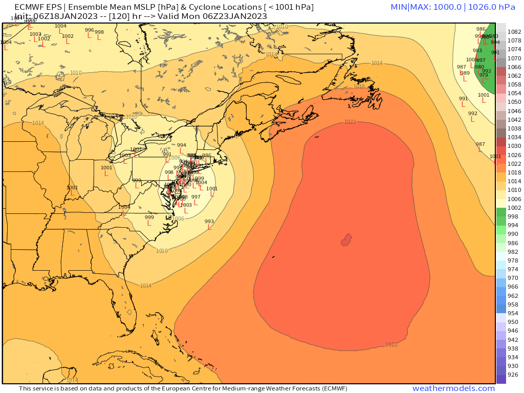
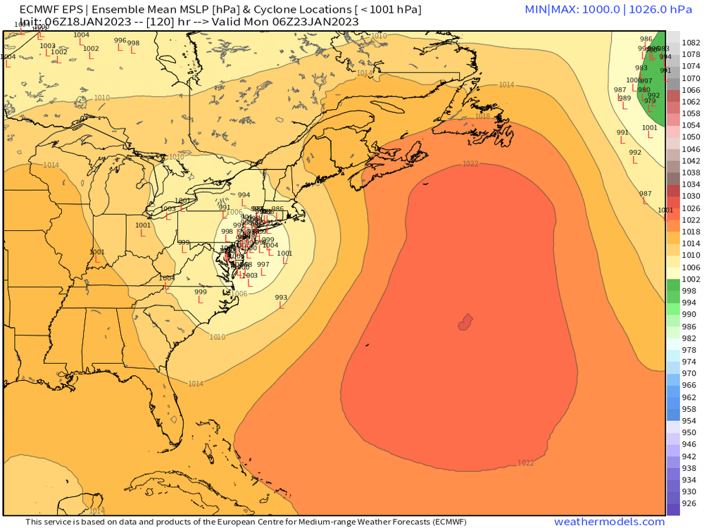
Nice middle finger going up the I-95 corridor south of New England.
-
Yeah this is an excellent pattern for NNE and hopefully filtering down into SNE with time as we get some better airmasses. Very active pattern.
-
1/25-26 will be a good hit this run for SNE I think. That’s prob the first one that has a realistic chance of being good here. Beyond that looks more favorable but at least with 1/25, we have some better looking upper levels with the PV getting closer and trying to intrude into Quebec.
-
NAM? That’s a D6 depiction. There’s actually an ongoing new thread for the Thursday system.
-
That one was run out of my basement….GGEM has to be the best model for phantom weenie snow