ORH_wxman
-
Posts
90,892 -
Joined
-
Last visited
Content Type
Profiles
Blogs
Forums
American Weather
Media Demo
Store
Gallery
Everything posted by ORH_wxman
-
Prob 2006-2007....you prob didn't get an advisory event until St. Patty's day that winter (unless you cracked 3" of sleet in the Vday storm).
-
Biggest problem is zero high/confluence. The airmass isn't great but it would easily be enough if we weren't getting blasted with southerly winds on the front end. Usually we'd have light E or NE winds out ahead of a system if there was any type of high.
-
1/23 is coming in pretty flat on some of these more recent runs (12z NAM....yes i know it's the NAM), 06z Euro and even 06z GFS came in a bit flatter though still more amped than the other two. That setup has such a bad high placement though that I think even a decent track would only benefit interior SNE.
-
Ray is still promising me 1956 ending.
-
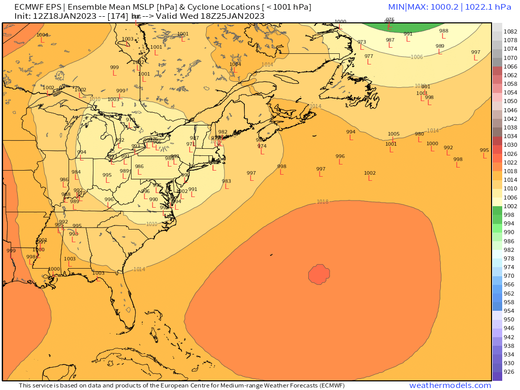
Both systems look like ka-ka for SNE....1/25 has a better chance to do well, but we'll need some luck on that one too.
-
Most guidance has been shifting north with Friday stuff. It looks like mostly north of pike now....though you still may get a little. But I think best chances for 2-3" would be north.
-
The snow near and south of the pike is mostly dependent on Friday. Some runs look really good and others are just a few snow showers.
-
I basically need between 55-60” from here on out to reach average. Not happening without some big dogs.
-
First euro run that really hits the Friday stuff decently too.
-
1/23 back to being torchy on GFS except for far NNE. But 1/25 coming in decent again.
-
That Friday stuff on GFS is getting pretty impressive. Looks a little colder than the 1/6 IVT which struggled to accumulate but a lot of that depends on snow growth too.
-
Really good cross-hair sig on the NAM in that area too....that's both good for keeping it snow and also increases risk for power issues since you start getting hooked dendrites near freezing creating massive aggregates that stick to everything.
-
Spread is massive though....the individual plot looks like buckshot...tells me we'll prob see a lot of model volatility over the next couple days on that one

-
The pond near here was like 5-6" thick ice in Dec 2013 and Dec 2017 with people skating all over it and playing hockey. It's open water right now (had some thin ice yesterday but its gone today).
-
Potential for 2010 MLK-esque melt is pretty high. Esp if this trends even another tick colder and he’s watching BOS get pounded for several hours.
-
EPS continue to slowly shift 1/23 SE…good sign for CNE/NNE.
-
Yeah this run had a nice little min-area of confluence set up ahead of the storm, which gives you some wiggle room. It's still somewhat precarious, but if that confluence is there on future runs consistently, then we'd have a much more legit chance at a good storm. For now, still model fodder.
-
Don;t count on it....expect flurries/snow showers and be pleasantly surprised if you get a couple inches.
-
Euro is quite a bit better looking for 1/25-26.
-
Yeah....I'd expect mostly nothing though where we are....except maybe some on Friday if we get lucky. If we can get another bump colder then I think it would become interesting, but I'm expecting the whole thing to end up a little bit north of the 12z depiction....as seems to happen a lot in these types of systems.
-
Ray might finally get his jackpot fetish storm
-
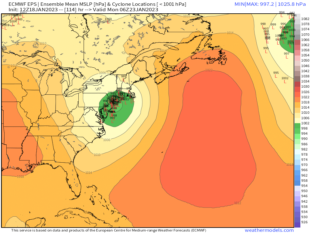
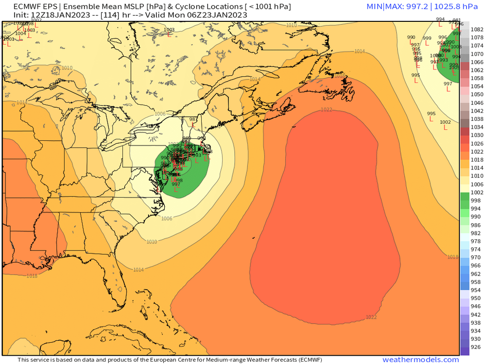
We had a similar needle-threader right before the onslaught in 2015....the system on 1/24/15 that got everything started was actually a really precarious setup with basically no high to the north and we just happened to get the trough in the perfect spot to ride the low just offshore and produce a modest band of 5-9" type snows across a chunk of the area. Same deal on this one...it's an airmass that really isn't that cold and there's no high holding any of this in (it slides quickly offshore). One reason I'm pretty pessimistic for snows in SNE until post-1/25....these airmasses aren't that good and hardly any of the setups of a decent high....with the delicious irony of Thursday being the exception. Only problem with Thursday is the airmass is so putrid, that a decent high only merely gives snows down to about the MA/NH border or rt2-ish region.
-
GFS came in flatter with 1/23 as well...not snow for SNE, but it's back to a big hit for CNE/NNE.
-
These are def the types of runs you want to see so far at 12z to give yourself just a little big of wiggle room. Of course, the Euro could piss in your cheerios which we've seen too much of this year. But I'm starting to feel a bit more optimistic for the NH border region than I did yesterday.
-
GFS is trying to rip an isothermal paste bomb for ORH now...that shortwave is getting compressed a bit on the 12z runs. That shortwave north of CAR is stronger. Again, not totally buying it down to the pike, but that is a good sign for the Rt 2 crowd....gives them a little more wiggle room for any north ticks that may try to happen in the final 24h.