ORH_wxman
-
Posts
90,902 -
Joined
-
Last visited
Content Type
Profiles
Blogs
Forums
American Weather
Media Demo
Store
Gallery
Everything posted by ORH_wxman
-
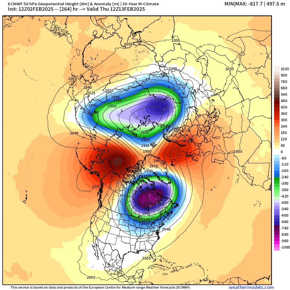
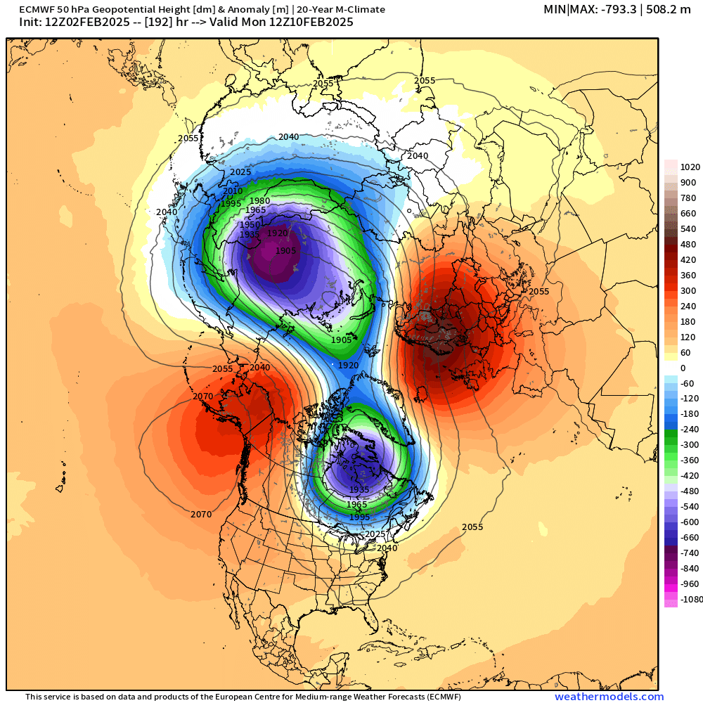
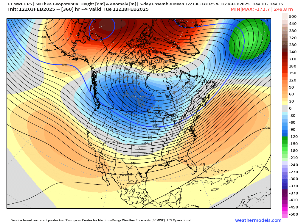
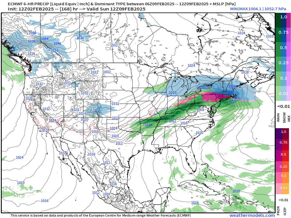
What a crazy arctic configuration by mid month
-
Euro has been waffling back and forth a bit on this threat. 12z run made the primary more zonked again so not much snow at all for CT/RI…and maybe only a couple of inches this solution for the pike region. But if you back off just slightly on that primary intrusion, then you could easily go 4-8” too. Details to be ironed out.
-
Tracking February 6. Light to moderate event potential
ORH_wxman replied to Typhoon Tip's topic in New England
Classic SWFE baking powder ratios. At least lower levels are nice and cold. -
Tracking February 6. Light to moderate event potential
ORH_wxman replied to Typhoon Tip's topic in New England
Def a period of IP/ZR but QPF won’t be prolific in this system so we prob don’t need to be worried about power issues, etc. But it will make driving and walking terrible. -
There’s like 3 events that are total rip offs from Jan/Feb ‘94. Hopefully we can cash in.
-
Water content determines durability more than anything else. A smaller impact is internal temperature of the pack and crystal structure but those are overwhelmed by water equivalent. Melting and refreezing doesn’t add water to it. It’s different if you add ZR or rain into the pack and then freeze it. That will add water equivalent.
-
Tracking February 6. Light to moderate event potential
ORH_wxman replied to Typhoon Tip's topic in New England
I’ll be happy if I grab 2” and then some sleet/ice before the dryslot. Most guidance does seem to triple point this over the cape/SE MA or thereabouts which would keep interior cold at the sfc. But this doesn’t look like a big snow producer really anywhere. Even up north it’s prob mostly advisory to perhaps some low end warning in a few spots. -
Tracking February 6. Light to moderate event potential
ORH_wxman replied to Typhoon Tip's topic in New England
I’d like to see euro go another tick colder, but yeah, we might get a net gain out of this if we can keep that triple point low coherent enough. 06z euro was like 2-3” for the pike region before the flip. Maybe just a smidge less for your area. -
Yeah the weekend threat is becoming more and more coherent on model guidance. Looks colder than the mid-week threat but still plenty of ptype issue. Might be a longer period of sleet/ice after an initial thump. But we’ll see how that trends over the next day or two.
-
Sunday Evening/Night Light snow event Disco/Obs
ORH_wxman replied to Sey-Mour Snow's topic in New England
2” in Holliston. Looks nice covering the surviving old snow. -
Sunday Evening/Night Light snow event Disco/Obs
ORH_wxman replied to Sey-Mour Snow's topic in New England
Interestingly right after I say that, snow growth improved a lot. Prob like 50/50 on dendrites now. Looks awesome in the lights. -
Sunday Evening/Night Light snow event Disco/Obs
ORH_wxman replied to Sey-Mour Snow's topic in New England
Really coming down but not great snow growth. It’s like heavy dandruff with an occasional dendrite mixed in. Looks like a white fog outside.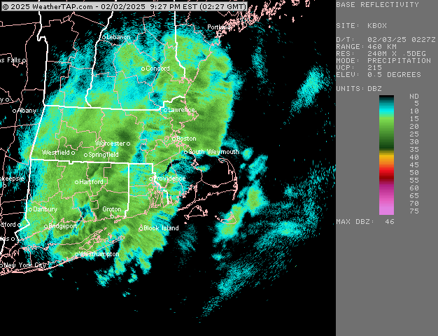
-
Sunday Evening/Night Light snow event Disco/Obs
ORH_wxman replied to Sey-Mour Snow's topic in New England
A couple of decent bands already..one going from ORH county to NE CT and another in the CT river valley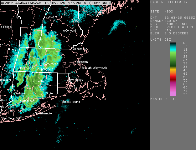
-
Sunday Evening/Night Light snow event Disco/Obs
ORH_wxman replied to Sey-Mour Snow's topic in New England
Yep. My back porch is “3 season” except when I make it 4 seasons with the Woodstove. It’s nice though because that wood stove helps heat the rest of the house too when I have it going strong so the furnace gets a bit of a breather. Keep the nat gas bill down. Thinking 1-3” here. I expect any lollis to 4 to be further west and southwest of us. -
Tracking February 6. Light to moderate event potential
ORH_wxman replied to Typhoon Tip's topic in New England
Yeah it did. I’d like to see another tick but it did give a couple of inches on the front. This isn’t a very juicy system anyway though, so I’m mostly hoping we can get a few inches and triple point the sfc low so we get a net gain. I’m not setting the bar very high on this one. But there’s def a model war. GFS doesn’t even come close to sniffing freezing over interior…even where the snow flips to sleet/ZR. -
Tracking February 6. Light to moderate event potential
ORH_wxman replied to Typhoon Tip's topic in New England
Yeah looked a bit colder. Not buying it verbatim but maybe we can tick euro a little colder and at least get a bit of snow on the front end. -
Sunday Evening/Night Light snow event Disco/Obs
ORH_wxman replied to Sey-Mour Snow's topic in New England
Weenie flakes here for the past 10-15 min. Really tiny. Almost didn’t notice them until I was outside getting firewood and saw them very diffuse in the spotlight. -
It actually has our side strengthening after the split happens. That said, I don’t necessarily need -30C 850s over our noggin.

-
@CoastalWx 192h now…almost inside a week now.

-
Sunday Evening/Night Light snow event Disco/Obs
ORH_wxman replied to Sey-Mour Snow's topic in New England
Euro looks like it had a little jackpot near Kevin…maybe just east
-
OP Euro is much colder next weekend than 00z as well…nice thump in front end with the classic bent back ML WF
-
Anyone who has tracked these types of events for more than a few years should know what the deal is. It’s on them if they think it’s going to be 2015.
-
They can also trend colder too when you have these type of airmasses in place and a high trying to hold on near Houlton…good for front enders. Hopefully the sludgy cold airmass wins out.
-
I think as long as people don’t expect Feb 2015 and understand there will be some messy ptype events, then most who like winter will be encouraged with what’s shown. Prob some good front enders and maybe even a legit icing event at some point…we’ll see. Sleet will be in play too of course. But seeing lots of low level arctic cold ahead of these systems is something that has been absent for several winters now. It’s one reason I’ve been fairly optimistic on this pattern since last week….low level arctic cold is hard to move and model guidance often underestimates it. So unlike all these systems the past few winters where we are trying to hold onto an antecedent airmass that has -1C at 925 and -3C at 850 (which will provide very flaccid resistance), we have these much deeper entrenched airmasses with -10C or colder. Much harder to eradicate and your “correction vector” as Tip wound say, becomes biased toward the cold side.
-
Sunday Evening/Night Light snow event Disco/Obs
ORH_wxman replied to Sey-Mour Snow's topic in New England
It spells weenie….each image is a letter. Ya’ll are blind, lol