ORH_wxman
-
Posts
93,092 -
Joined
-
Last visited
Content Type
Profiles
Blogs
Forums
American Weather
Media Demo
Store
Gallery
Everything posted by ORH_wxman
-
I was actually serious. Lol. It would be a fun read.
-
Congrats man. Another huge storm up there. Great start to the year there.
-
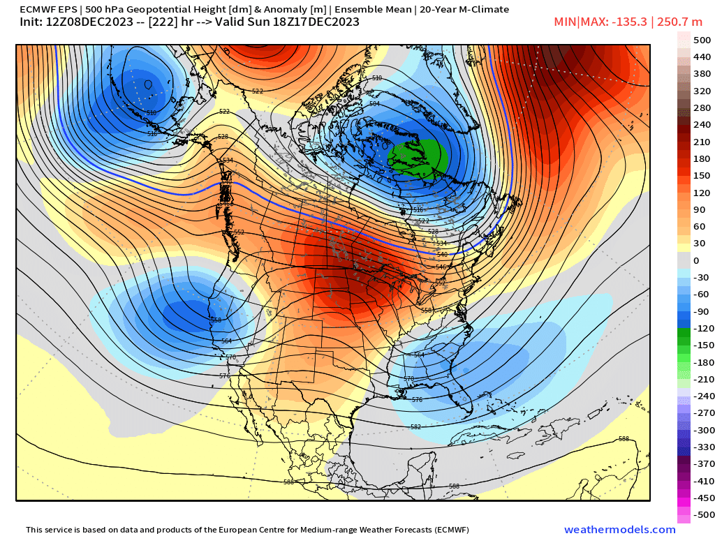
I actually mentioned something semi-similar in the New England forum about how the excessive EPO block (really a bit north of the classic EPO region…more into the Arctic Ocean) and the subsequent downstream PV near Hudson/Baffin has some correction potential to the south. This could be seen even in the week prior to Xmas. I know the post above was talking stratosphere, but those features are somewhat reflected in the upper troposphere.
-
Once you are retired from the regular rat race of 9-5 work, we need you to write a book about the psychology of the weather forums…maybe even document the changes from the early years of the 2000s to the incessant whining of the present day, lol.
-
The N PAC raging jet is a good sign because that’s how you get an Aleutian low to set up shop…something we haven’t seen this cold season yet consistently. Wont be much cold into Canada initially but we can still get threats (06z GFS is an example)…as the Aleutian low matures more, you hopefully start pumping up the PNA ridging and you begin to get some colder temps.
-
Actually gives us two storms…Dec 19-20 and then it looks like on Xmas day if it went one more frame. That would change all the whining in a hurry.
-
It would likely be that type of airmass if we got enough cold in place. But no way you’d expect a storm of that magnitude at this time range.
-
I think there’s room for that one to trend cold enough for snow. 18z GFs nearly pulled it off here…further interior got croaked that run.
-
I've always said the NW wind events in winter will outperform the southerly events 90%+ of the time. Maybe we can get a 3/8/05 stinger on the back end....wish we could get a few hours of blizzard like that one, but beggars cant be choosers.
-
18z NAM went east again....gets western SNE into accumulating snow. @RUNNAWAYICEBERGdoing naked snow angels while me and Ray get rained on?
-
I have some hope that one can correct colder. You have a big block N of AK and a PV in N Hudson Bay/Baffin….get that northern branch to correct SW a bit and maybe we have something. That correction would prob push the central US ridge westward a bit too.

-
Honestly, our region of the country has one of the longest lags…if people want the seasons to match the annual solar cycle, then they should move to the intermountain west. Many of them have their climo nadir in temps around mid to late December.
-
In La Niña it would be more concerning since December is supposed to be better during Ninas…but this year is obviously the opposite. The tropics are pretty telling so far this month…rotating the MJO through 4-5-6 is going to produce what we’re seeing now.
-
2/24/98 was a bad one.
-
This recent stretch is good for you my friend…it will teach you to appreciate the big winters. I was “lucky” enough to have the worst 4 year stretch in recorded history at ORH in my childhood so I was exposed to huge failure early on which really made those big winters feel a lot more special.
-
Almost time to roll the windows down on the explorer.
-
Looks like Stein….we get a cold shot on most guidance during that period but it’s dry. That could change but right now it looks boring.
-
2002 was pretty nice. Over a foot…I think you stayed mainly snow there too in Wilmington though maybe a period of sleet crap at the height for a time.
-
It’s def a boring pattern for now. When northern stream starts getting more active it will be interesting. Middle of this month has a classic December Nino ridge across central Canada which is a good bet for Stein around here unless you get lucky with a well-timed southern streamer…but I think we start shifting things more favorable in the final 10 days of the month.
-
Yeah his description fits with the weather that happened in 1975 even though I didn’t personally witness that. Big system between 12/20-12/22 and then cold. 1976 actually had a mini-grinch on 12/21 that wiped out a moderate event that fell 4 days earlier…and 1977 was just putrid and in the 40s for the week leading into Xmas which wiped any thin pack that was remnant from earlier that month.
-
Nothing will beat 1997 though…looked hopeless but then on the 21st we start seeing that chance of an inch or so on 12/23….the night before they said 1-3” inland but wouldn’t be surprised if it was less…then bam, 18” later. 2012 was also a fun one even though it was way less snow. Had about inch or so of currier and Ives fluff predawn until about 9am Xmas morning when it was looking bleak even the day before.
-
Based on the most recent decade being pretty skimpy, any linear regression trend on White Xmas around here is going to be negative. But if you throw another 2000s type decade on the dataset, then it might change it…we had a really brutal stretch of lean White Xmas in the 1930-early 1950s period…so if you started from there and ended in a year like 2010, you’d have a positive trendline. I don’t think it’s going to become more common than the 20th century mean though…a huge component of a White Xmas is keeping existing snowpack from melting out before that date and warmer temps simply make that harder. Even if you partially offset it with somewhat more frequent sizable events from working with more moisture.
-
He knows. This is his way to deal with no snow yet. It’s also CON he’s looking at and not CT…and even in the 1800s CON had plenty of duds. It’s true it’s a little easier now to have them, but not nearly to the degree which some in this thread proclaim. It’s not backed by the data. I’m pretty sure a chunk of weenies think that anything pre-1900 (or even pre-1950) was like a Quebec City climate in Boston….when in reality either period was still decently warmer than modern day ORH.
-
1875 weenies jumping off Old Man on the Mountain ledge….couldn’t sleigh until 2/4.
-
Yeah….I could also see a lot going right too…funny how that works!! The ridge is actually in the process of amplifying on that panel so that pattern is probably improving with time. That roughly lines up with the weeklies too.