

ORH_wxman
-
Posts
93,094 -
Joined
-
Last visited
Content Type
Profiles
Blogs
Forums
American Weather
Media Demo
Store
Gallery
Everything posted by ORH_wxman
-
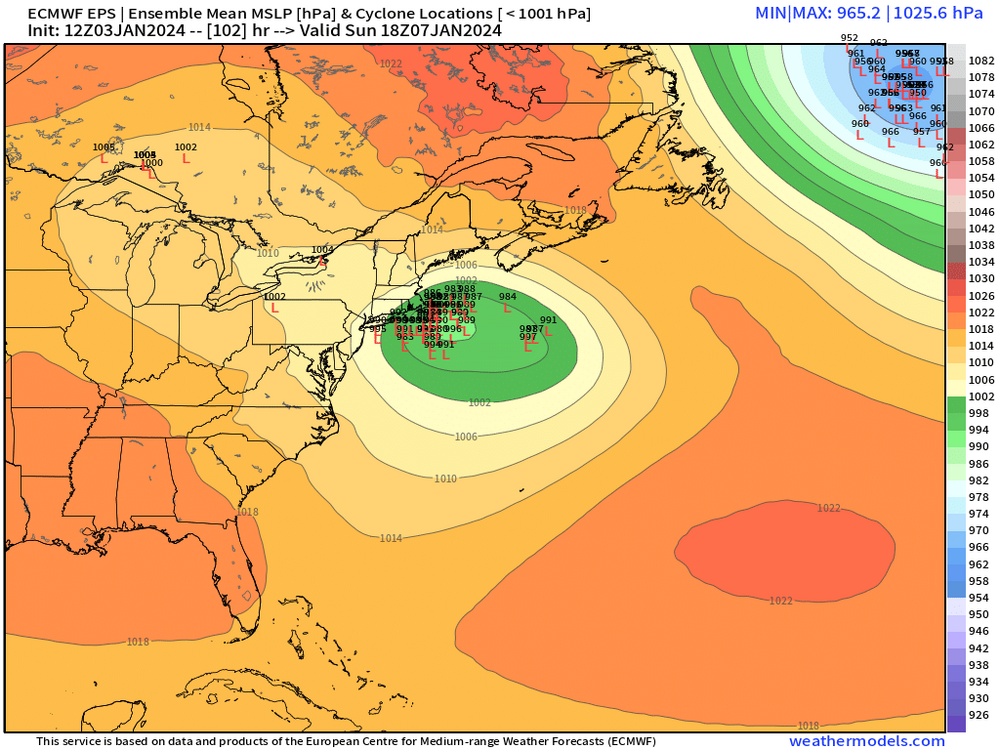
We were lucky if the 0C 925 line was SE of ORH, lol. So many events were so marginal and a lot of it was because we had zero high pressures in a decent spot.....the 1/7 event finally has a decent high that is able to funnel down good air into any CCB.
-
NAM still looks like it would mostly be the trailing shortwave. It did take a bit longer this run to grind up the lead shortwave so maybe it will eventually trend toward other guidance.
-
PRetty clustered tightly still
-
MEan has double digits now from ORH to BOS and maybe down to Foxborough.
-
Yeah that really closed a lot of the spread on previous EPS runs....tightened up all those lows.
-
Def a big risk in the 1/10-1/17 period....with that vortex trying to press into western Canada, there's a cutter risk. Hopefully we avoid them and they are mostly SWFE type systems or even overrunners if we can get that block to work for us enough. But that's definitely a risky period.
-
There's an initial big fronto band across SNE early Sunday from like predawn to early morning and then it starts to rotate and regenerate further NW as the day goes along.
-
You're in a good spot for 1/10. Want to be northeast for that one. Seems like you'll at leats get decent snows in 1/7 too even if Euro was a little too happy at 12z.
-
Even this run gets warning crtieria snow to N ORH county over to N Berks....prob advisory type stuff close to the pike (and N/W of 495)....needs more work to look like the GFS/GGEM, but that was a nice improvement from 00z.
-
Euro is starting to cave to GFS/GGEM....still think this run won't be as good as those runs, but it won't be as torchy as 00z.
-
Yeah we nearly lost the lead wave on this run, but it was running NW of the previous runs, so it kept all the forcing near the coast and inland instead of getting swept seaward.
-
Does the quasi-capture scenario that is ideal for still getting heavy burst of snow and then prolonging the stuff on Sunday
-
Euro looks a bit more amped than 06z through 60 hours.
-
You can ignore the Ukie clown map close to the coast...it has a bad warm bias near the sfc, so it often shows rain like 10-15 miles inland despite 925 temps of like -3C.
-
PV over western Canada....NAO saving our bacon like one of those late '60s winters.
-
Ukie is a bit tamer than 00z....doesn't have that 12"+ type snow from BOS-HFD south....more like 6-10" with advisory stuff prob into S NH
-
On the point soundings for SE MA, it had a good cross-hair sig on the 12z run....your area may have been a little far NW on GFS for the real goods in that department, but it wouldn't take much of a move to get into them.
-
CC causes the emergence from the warm season cocoon to happen later than we're used to.
-
Yeah this isn't the thread for 1/10....lets keep this one about 1/7 so peeps don't get confused.
-
Seems like that trailing s/w being stronger in the 1/7 event plus it's trying to phase a bit with that northern piece traversing the N stream is locking in the confluence better for 1/10 on some of these runs.
-
GGEM might be even colder than GFS....big event for all of New England.
-
You might struggle to hit freezing on that look until right around FROPA when you mix.
-
Big front-ender on GFS for 1/10. Warning crtieria for a lot of SNE before the flip.
-
12z GGEM is poundtown with the lead shortwave....crushes CT over to SE MA...but all of SNE gets good snow.
-
There's the re-invigoration Sunday PM on the GFS as the trailer catches up....some nice bands redevelop over much of SNE.


