ORH_wxman
-
Posts
90,902 -
Joined
-
Last visited
Content Type
Profiles
Blogs
Forums
American Weather
Media Demo
Store
Gallery
Everything posted by ORH_wxman
-
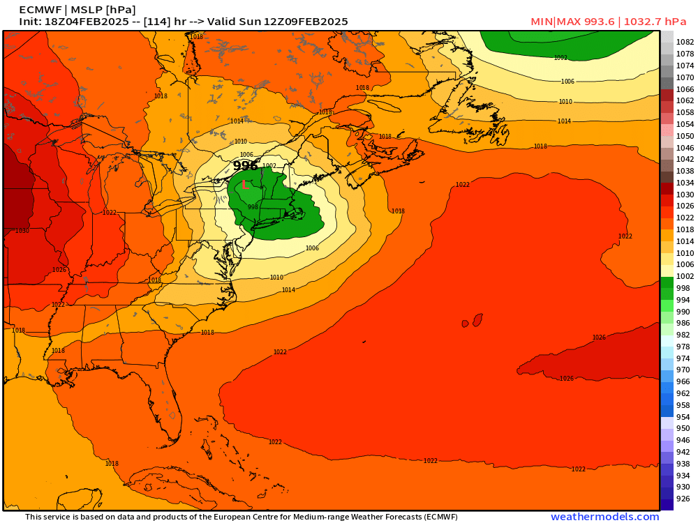
How long has it been since we saw this type of Scooter high with a juicy system coming out of the south? It’s starting to get that “look” where something larger could happen…just need to get this a bit closer but the cross-guidance support is really strong for being a week out
-
Almost reminds me of this event http://www.meteo.psu.edu/ewall/NARR/1994/us0107.php#picture
-
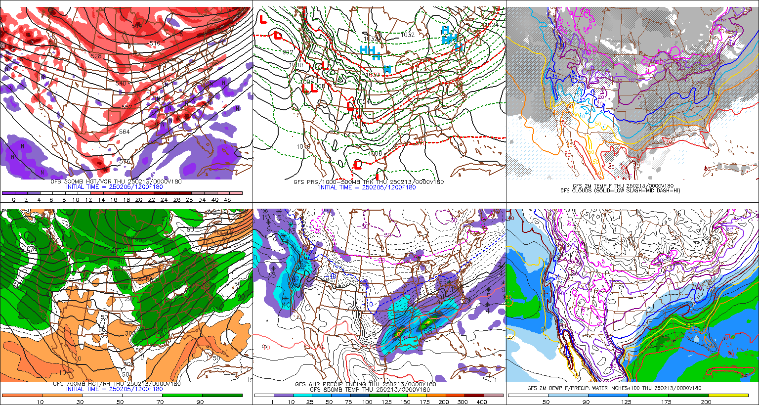
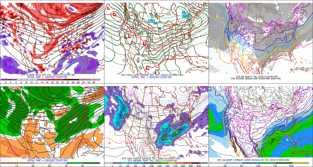
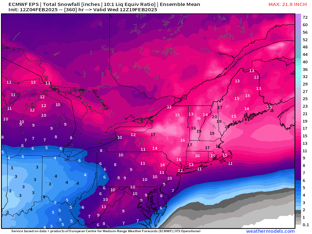
Tracking February 6. Light to moderate event potential
ORH_wxman replied to Typhoon Tip's topic in New England
Commutes might not be that bad for most. Much of this falls after morning commute and ends before evening commute. Exceptions might be SW CT where it could affect the morning commute and then further northeast into Maine where it could still be steady precip during evening commute. -
Little bit of CCB getting going.
-
Tracking February 6. Light to moderate event potential
ORH_wxman replied to Typhoon Tip's topic in New England
Just not a whole lot of exciting dynamics with this thing. The hope is that the vort attenuates a little less than model guidance shows which would strengthen the thump. But otherwise I think 1-3” for many. Maybe some 4” lollis north of pike into CNE. All guidance keeps the secondary sfc reflection SE of the region now so I don’t see any liquid precip over the interior. -
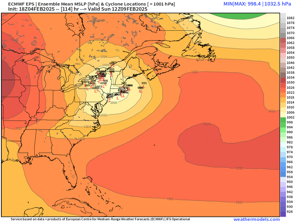
How can you say that without it posting a clown map for Moonshine? I will say the most impressive part of the EPS run is the 6” mean for BOS-ORH (and you can extend that basically down to HVN) for next week’s event (the event after Sunday which could be a prolonged overrunning situation)…impressive mean for that far out.
-
06z EPS tickled a little colder and a little weaker with primary into NY state…slight faster transfer. N of pike to central NH looks excellent on the mean…but still nice thump for even S of pike folks.
-
06z euro pretty nice thump for BOS-ORH. 6-7” or so.
-
Euro suite still a bit more amped than other guidance for this threat. Still a nice front end but def more mixing/ptype issues further north.
-
18z op vs 18z EPS…pretty decent match actually as 18z EPS amped up a little bit from 12z …OP still on the stronger side but not by a ridiculous amount…this one def has more dynamics than Thursday.
-
18z OP euro is still pretty amped. It’s a good thump before mixing but def more amped than the ensembles.
-
Tracking February 6. Light to moderate event potential
ORH_wxman replied to Typhoon Tip's topic in New England
Yeah the tick colder on 18z euro makes the difference between all guidance pretty small now save for the very paltry 3k NAM but hard to take that seriously yet. Maybe inside of 36h start giving it any weight at all. -
Tracking February 6. Light to moderate event potential
ORH_wxman replied to Typhoon Tip's topic in New England
Yeah I'd want to see more guidance spitting out 0.40-0.50" of snow QPF before going anything above 4". Maybe that happens at 00z, but it's entirely possible it's mainly a 0.2-0.35" type event on the snow front. -
Tracking February 6. Light to moderate event potential
ORH_wxman replied to Typhoon Tip's topic in New England
Not an appreciable difference in 18z GFS. PRetty consistent with other guidance for most of us. On the margins there might be changes. Maybe a touch weaker with the initial thump down in S CT if we're nitpicking, but still a pretty cold run with the sfc reflection tracking from near Delmarva to ACK. -
Tracking February 6. Light to moderate event potential
ORH_wxman replied to Typhoon Tip's topic in New England
I'd take the over on 1" and there's a chance it could be 4-5" if things break right...not a large quibble though. I think i'd go 2-4 and prob 3-5 if we can eliminate some of the weirdo solutions by 00z like the 3k NAM giving us 4 hours of SN- that amounts to 1-2"...or some of those zonked Euro solutions which give us 2-3" but dangerously close to giving us 1". -
Just for moonshine....
-
Tracking February 6. Light to moderate event potential
ORH_wxman replied to Typhoon Tip's topic in New England
At least for the pike region, the models are pretty consistent about advisory snows....including the Euro. Down in CT, it's basically every model except the Euro. edit: I'll note that the EPS mean for Hartford is around 3" though, so it's a bit more bullish than the OP run...most noticeable difference is down in S CT where the EPS mean is 2-3" vs C-1 for the OP run. -
EPS is pretty bullish on this threat. Mean is around 6” for BOS. A little less but still 4-5” across much of CT.
-
Tracking February 6. Light to moderate event potential
ORH_wxman replied to Typhoon Tip's topic in New England
You need to maintain that leading vort…if it attenuates too much you lose those dynamics…aka, no bent back ML warm front…instead it’s just kind of a weak general isentropic glide with no defined area of enhanced vertical motion. I think it will produce enough for solid advisory snows but not more than that. -
Tracking February 6. Light to moderate event potential
ORH_wxman replied to Typhoon Tip's topic in New England
I think most of SNE (and even up into CNE) will spike pretty decently. We have 925mb temps of like +4 or +5 and you mix that down with FROPA. I don’t think it really matters in terms of melting much snow since it’s dry by that point with lower dews and at night so no aid from sun. But it may briefly melt any glaze that happens from during the day. If we end up with a more suppressed solution though then maybe it never gets that warm. -
Tracking February 6. Light to moderate event potential
ORH_wxman replied to Typhoon Tip's topic in New England
Warmest temps will likely be overnight Thursday into predawn Friday with FROPA. Could spike brief 40F and then temps drop during Friday morning. -
Euro was pretty decent this event. Solid front ender. Low end warning criteria for many in SNE.
-
Tracking February 6. Light to moderate event potential
ORH_wxman replied to Typhoon Tip's topic in New England
Euro was def a tick colder than the 06z run. -
Tracking February 6. Light to moderate event potential
ORH_wxman replied to Typhoon Tip's topic in New England
Weathermodels kept saying it was out to 144 like 10 min ago but none of the maps loaded anything. -
06z EPS actually had a lot of redevelopers which kind of surprised me considering the OP run was a bit uglier. Those would both enhance dynamics a bit and prolong the snow before a flip to IP/ZR.