

ORH_wxman
-
Posts
90,902 -
Joined
-
Last visited
Content Type
Profiles
Blogs
Forums
American Weather
Media Demo
Store
Gallery
Everything posted by ORH_wxman
-
I think we went like 4+ seasons without a benchmark track 1988-89 through 1991-92. Couldn’t freaking buy a storm those years.
-
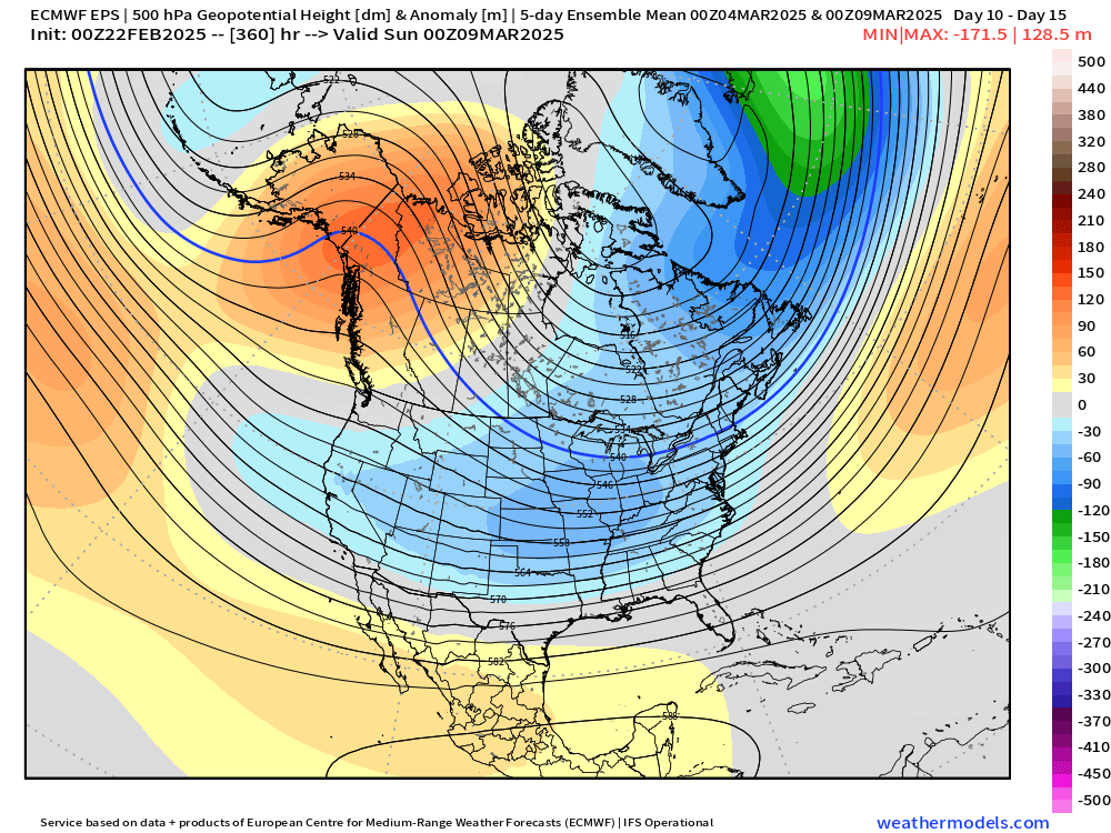
EPS def likes Mar 9-10 for a last effort to give us something significant.
-
Of course a stemwinder 980-something near BUF was no problem 10 days ago when even a slight attenuation would’ve produced 10-15” of snow easily prior to mixing. Guess the PAC jet didn’t get the memo on that storm.
-
Yeah it’s just curve-fitting over a relatively small sample imho. Monster cutters are because of west pacific warm pools…apparently so are VA and Carolina snowstorms.
-
GFS on its own with the confluence next week. It has the northern stream press down ahead of the southern waves. GGEM and Euro just phase them together and we get a monster cutter.
-
His area was prob due for the hardest reversion to the mean of anywhere in SNE. That BOS to south shore stretch performed just obscenely above long term climo for a long time. All those 128-495 storms we had growing up seemed to really not be as prevalent during the 2000s/2010s. The south shore jackpotted or near-jackpotted so many storms. We’ve seen a return to a few more of those 128 or 495 storms since then to go along with shit winters in general. That said, I didn’t think the reversion would be this extreme over a 3 winter period. It’s like Mother Nature is trying to make up for everything over the last 20 years there inside of a 5 year period, lol.
-
You gotta give the southerners a break on the snowfall measuring. They will eventually learn there’s no such thing as a unit smaller than one tenth when it comes to snowfall.
-
It’s too bad we couldn’t get that clipper to slide underneath SNE. Pretty vigorous-looking…could’ve been a nice little event. Story of the year though…nothing really trends correctly. We had a couple trend south of us and whiff earlier this winter…didn’t get the north trend when we needed it. Now we don’t get the south trend when needed. This winter has felt like we left about 70% of the potential sitting on the table.
-
I cut through some residential neighborhoods in Quincy on the way to work and it was getting the look where sunny side of the road was getting beaten up pretty bad while shady side was still full cover.
-
Yeah I don’t see the shaded sides of the street going here. We (and esp you) might even pick up a couple inches Thursday morning too.
-
There’s actually a chance for an inch or two on Thursday morning for near pike and especial northward. The front end of that weak system has trended colder.
-
Big gradient in snow pack around 128. Really got thin as I passed the 93/95 change near Westwood. Even in Dedham it was getting thin but it got beefier back in Dover/Sherborn.
-
Outside of something rogue very late, Mar 5-12 stretch is prob our last best shot at something decent.
-
Maybe up by powderfreak it's worth tracking. GFS was on crack....18z Euro run yesterday was rogue.
-
Yes but i think these are weighted against climo? So if it's higher than the typical baseline, it would screw things up potentially.
-
Def gonna happen just so early April is ruined.
-
Love the 2nd to last picture. Nice view of Pleasant Mountain there? I recognize it from when we go up to the same Lake house every summer on Moose Pond right in the shadow of it.
-
2000 was 80+ I remember. Also I think mid-March 1990 had a sneaky 80s at ORH….very hard to do there.
-
I remember everyone at work and out and about saying that in 2018 when we had that February 70F torch and then we had 40”+ in March. I’m sure this year will be 45F and rain.
-
Pretty big strat warm signal on ensembles for early March. That will manifest as a perfect pattern at the end of March and April. Welcome to Tip’s favorite season.
-
You’ll be rewarded with 50% of the days being Atlantic ass mist once you celebrate the end of snow threats.
-
Yes. Also doesn’t mean that will continue. Or…maybe we get an ugly looking chart mid-month and it produces a storm which sometimes happens in March with shorter wavelengths.
-
Everyone always tries to rush the end of winter every late February and March. It’s like we all of the sudden live in Virginia.
-
The first half of March looks pretty interesting. Maybe we can finally pop a big one, but probably not.
-
No the flash freeze event was a few days earlier on 3/8/05. That’s the one that had massive winds too. The 3/12/05 event was basically an advisory event that busted positively into a big warning event. It was essentially a really juiced inverted trough with the low going offshore but the upper support was hanging back and we just pounded snow almost all day. I think we ended up with 11” or so when 3-6 was the forecast the night before.


