ORH_wxman
-
Posts
93,099 -
Joined
-
Last visited
Content Type
Profiles
Blogs
Forums
American Weather
Media Demo
Store
Gallery
Everything posted by ORH_wxman
-
Oh right. Forgot the 0.2” in December.
-
Yes. They’ll have a legit shot at it if they go into February at 3.8”. But I have a feeling the upcoming week is going to put a dent in it…even if neither system is a blockbuster.
-
Eh, I didn’t really take it offensively. I mean, he kind of had a point. But you’re also correct it’s offhour waiting for next guidance to start arriving.
-
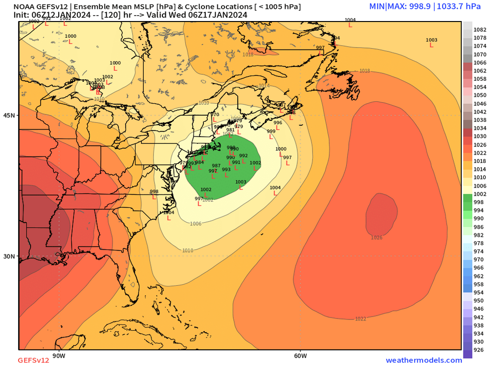
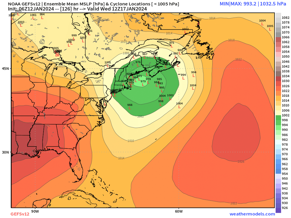
Both storm threats next week have been kind of late bloomers more often than not on guidance. There’s been a couple stemwinder runs mixed in but a mostly been lot of last-second development
-
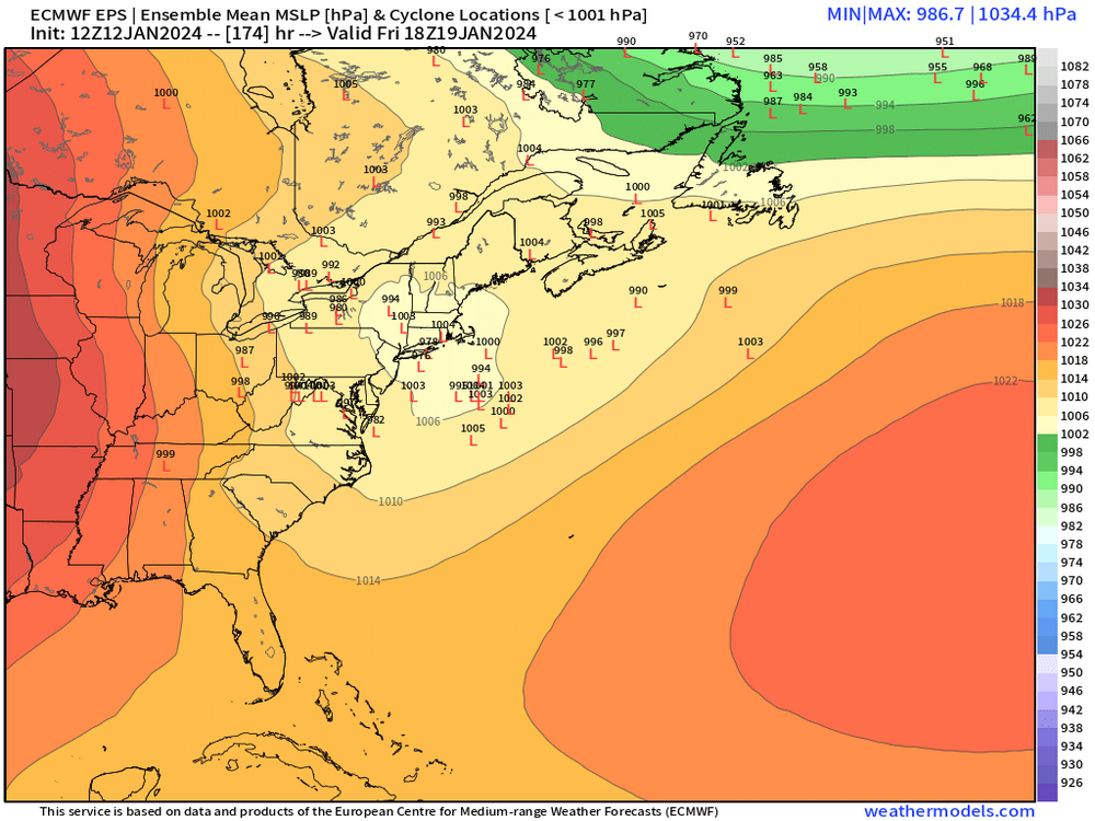
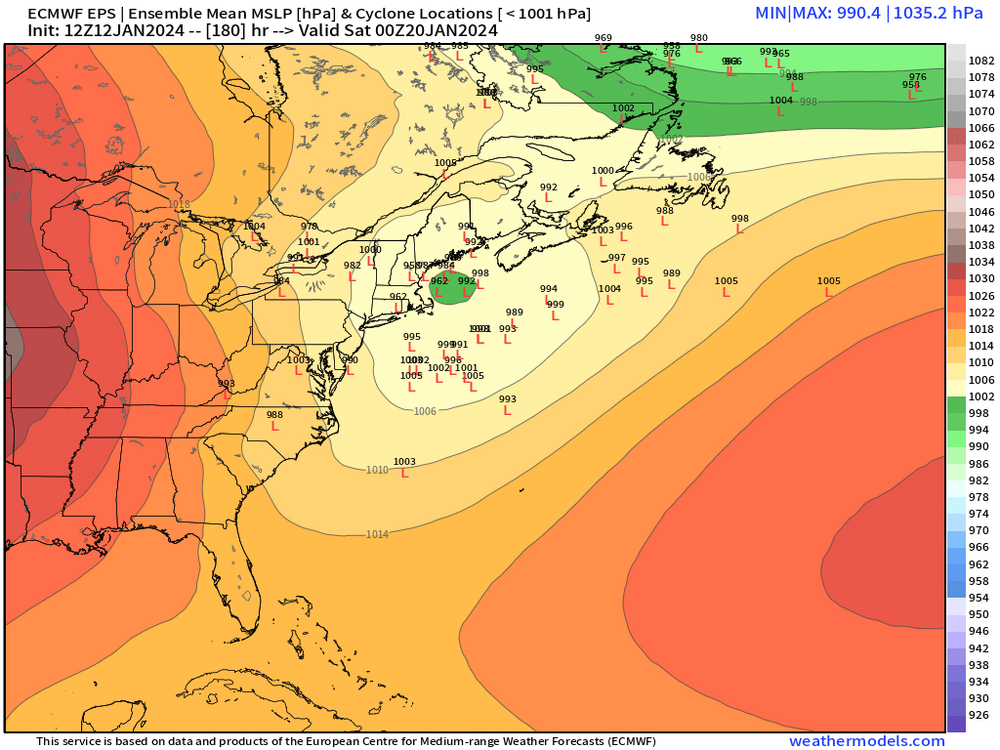
Other thread for 1/16 threat. 1/20 is still there on guidance but nothing overwhelming yet that screams we’re going to get crushed. There’s high-end potential though because some classic ingredients are there for a higher end storm if a nice piece of PV lobe breaks off. As Wonka used to say…”strike that, reverse it. 20th threat talk is in the other thread”…but otherwise everything else I posted was correct.
-
Yeah you could get skunked the rest of January and then put up a 30 burger in Feb and then all you need is like 11” in March to hit average. But obviously another event or two in January will make it a lot easier.
-
Yeah you need to get some hits since we didn’t back into any events in December and didn’t get either cutter this week to work itself into a more respectable SWFE….when you bat .000 in those, you need to take advantage of your more favorable setups if you want an AN snow season in New England. We can’t just get one or two storms to do it like the Mid-Atlantic. Esp away from the coast. We need a steady diet of warning events. If 00z all trends SE then this threat is prob done. But I don’t have much confidence what it’s going to do given ensemble spread.
-
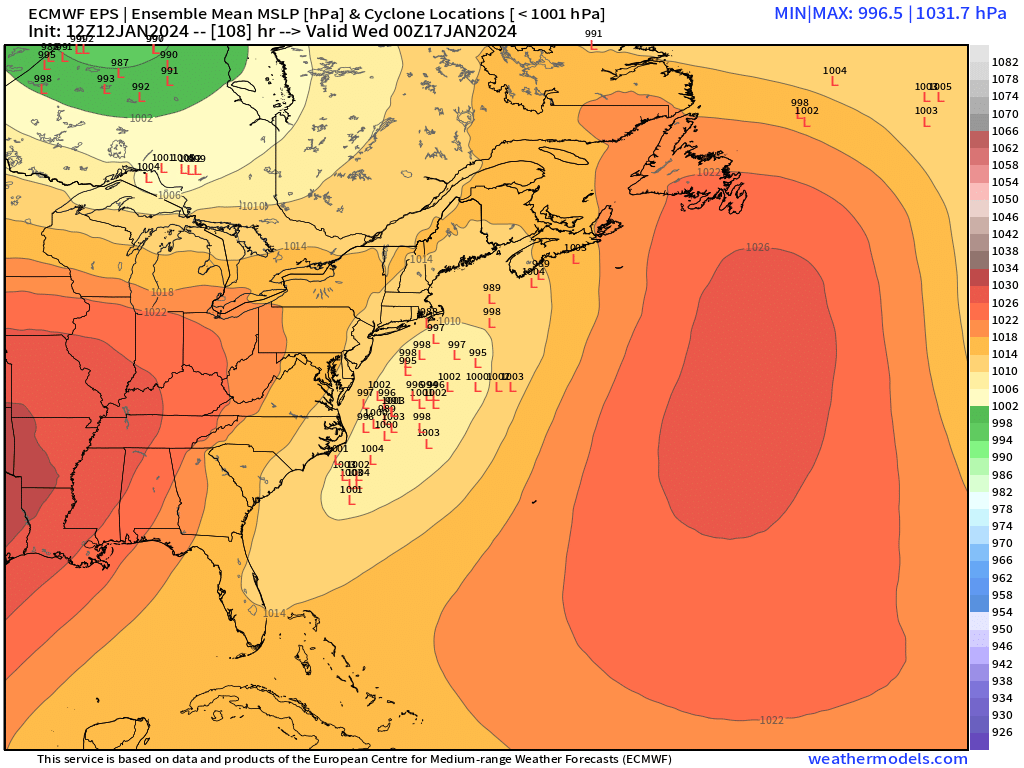
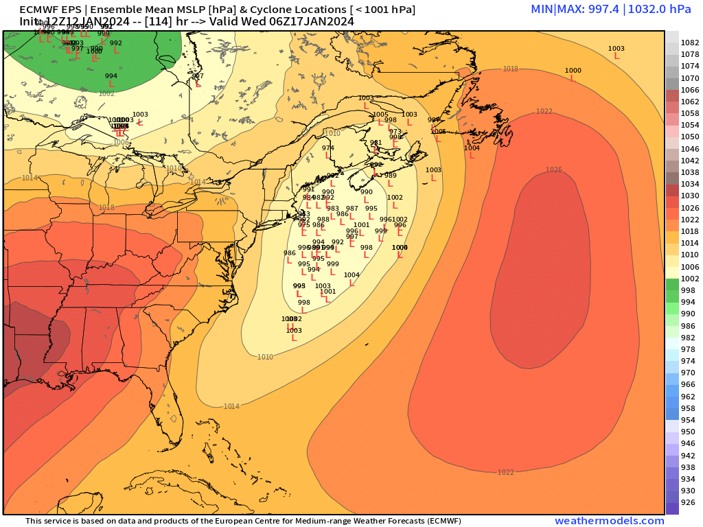
He’s def teetering a bit. You can feel it in the tone of the posts. Honestly, this system has had a LOT of spread the entire time. Nobody should be confident of any solution. You have some larger scale positives but then some other negatives like compression/velocity….we don’t know which one will win. When you have an ensemble suite at only 102-108 hours out with some 980mb members sitting over ACK and then some weak strung out lows near Bermuda, that tells you all you need to know about confidence.
-
Same reason people confidently say it’s going to whiff when they actually don’t know. There’s this need to be “first” or maybe people just want to pretend to know…not sure the psychology behind it, but it goes in both directions before every threat.
-
No they weren’t. That cutter on Tuesday was wobbling like 300 miles at a time in the week leading up to it. Dendrite even posted an animation when someone claimed cutters don’t move. I honestly don’t understand the memory-holing of this concept every time we point it out. Is it some sort of defense mechanism? Cognitive dissonance? I’m just not sure why people ALWAYS make that type of claim. Im not just picking on you here…so many others do it.
-
Yeah most didn’t get that much but maybe a few spots in the berks and Litchfield hills. But a widespread 2-4” over interior SNE. The event weakened a little as it approached the coast so they were more like C-1”
-
Almost a perfect vort track…just a bit too sheared…yeah, def still too early to be getting close to pulling the plug.
-
Yeah I had almost 4" in 45 minutes (I think it was like 3.7 or something) with multiple flashes and rumbles plus we went from like 31-32F at the onset to teens within a cvouple hours. True arctic WINDEX event on 'roids.
-
1/28/10 was the one you're prob thinking of. That was an epic setup. We're not repeating that since winds are too much westerly component in this one, but there def could be some pretty good squalls.
-
Save for this past week when we had a brief stall near phase 2/3, we've been just ripping along on the RMM plots for the MJO, and the waves have been high amplitude too since the week of Xmas....so yeah, that isn't typically going to be associated with weeks-long pattern stagnation. You want weak MJO or almost none at all and that's when we can get those standing wave type patterns that lock in. OR we get lucky with blocking which mitigates other more hostile factors. We lose the blocking after the 1/20 threat though.
-
That warmup has been advertised fairly well by ensembles. It doesn’t look like a weeks-long ordeal though since the PNA ridge out west is rapidly rebuilding by the end of the month…so I think that bodes well for more threats in early February. But we’ll see. There’s always nuances we can’t see at this range. Even in milder patterns, you grab a well-timed Scooter high over Quebec and you can grab a nice snow event. Vice-versa, we can still get ugly cutters in favorable longwave patterns.
-
Ensembles have it…tho obviously tons of spread
-
Euro def looks like a powderkeg setup next week. The ingredients are there, it’s just a matter of timing the vorts within the PV lobe.
-
I feel like that’s occurring across all guidance but you are right it’s more unusual for the Euro to have decent sized swings inside of D5. This is a system huge problem on model guidance for some reason.
-
Can’t complain about that move by the Euro. Solid improvement.
-
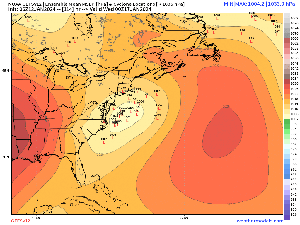
GEFS remain pretty bullish

-
There’s a separate thread for the midweek storm.
-
GFs is starting sniff out 1/20 a bit more aggressively this run. Good PV lobe separating from the main vortex.
-
Yep. Don’t see any major red flags at the moment other than compression but the synoptics are working in our favor for once to overcome a negative variable. Hopefully we can bring this one home in the next few cycles.