ORH_wxman
-
Posts
90,902 -
Joined
-
Last visited
Content Type
Profiles
Blogs
Forums
American Weather
Media Demo
Store
Gallery
Everything posted by ORH_wxman
-
Tracking February 6. Light to moderate event potential
ORH_wxman replied to Typhoon Tip's topic in New England
Finally some good snow growth in this band but we'll prob lose it in a few min according to radar. -
The only risk of a southward whiff would be if we saw this rapidly attenuate....but that doesn't appear to be the case on this event unlike today's.
-
Tracking February 6. Light to moderate event potential
ORH_wxman replied to Typhoon Tip's topic in New England
This is some of the worst snow growth...maybe about 3/4" of very dense snow. Can't imagine we have better than 8 to 1 despite very cold temps. -
You're not whiffing with a vort tracking over our fannies...what is going on in here?
-
Tracking February 6. Light to moderate event potential
ORH_wxman replied to Typhoon Tip's topic in New England
They started cancelling a lot more the night before after the Dec 2007 traffic nightmare storm. -
Tracking February 6. Light to moderate event potential
ORH_wxman replied to Typhoon Tip's topic in New England
Regional view shows the best and most organized slug of precip going for CNE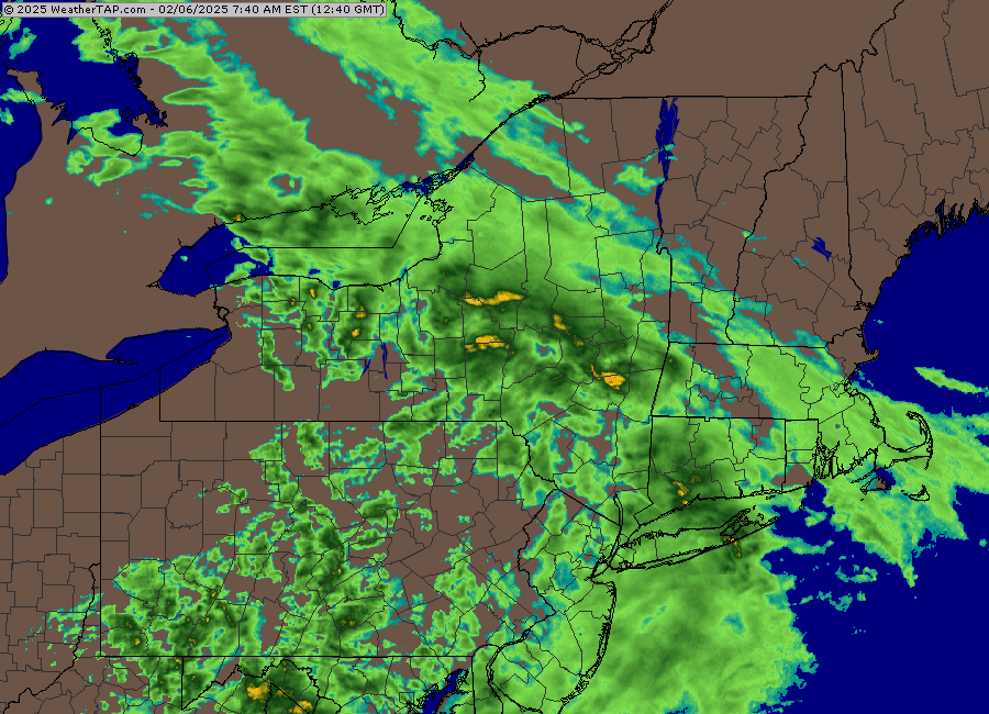
-
Tracking February 6. Light to moderate event potential
ORH_wxman replied to Typhoon Tip's topic in New England
Radar has been mostly putrid so far but it looks like it’s trying to get a little more organized. Snow growth here has been mostly terrible outside of about a 15 minute band earlier where we had a mix of baking powder and dendrites.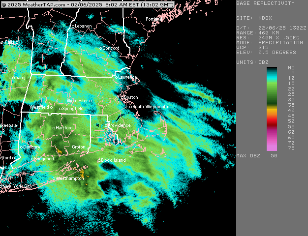
-
Steep lapse rates can greatly enhance lift via instability but it’s not the cause of it. The cause of the lift in this storm is warm air advection (isentropic lift)…warm air is being pushed into colder/denser air and causing it to rise over the top of it. If that saturated warmer air is forced to rise through a thick level of DGZ, then the snow growth is likely to be better than if it was a very thin layer of DGZ. In addition, a thin DGZ doesn’t have to be because of steep lapse rates, it can be due to an elevated warm layer too. Now you have the opposite of steep lapse rates.
-
Tracking February 6. Light to moderate event potential
ORH_wxman replied to Typhoon Tip's topic in New England
My kids have no school. They totally could’ve gone today. But whatever. Steady light snow here. Hoping to grab 2-3”. -
Tracking February 6. Light to moderate event potential
ORH_wxman replied to Typhoon Tip's topic in New England
Sleet line is extreme SW CT right now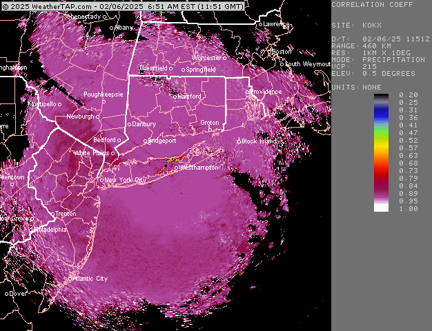
-
The thickness of the DGZ is just how deep the layer of -10c to -18c air is. It has nothing to do with how fast the air is rising through that layer. If you have something like -10C at 925mb and -18C up at 700mb, then that is a very thick DGZ. If that layer is confined to a narrower zone, like say, 800mb to 700mb, then it is going to be harder to get the best lift to line up with the DGZ.
-
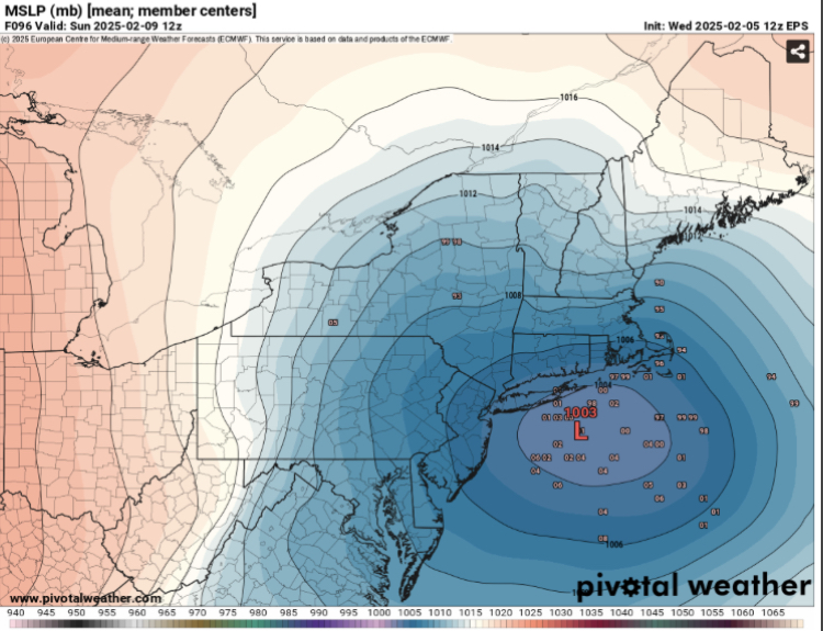
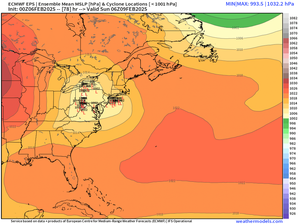
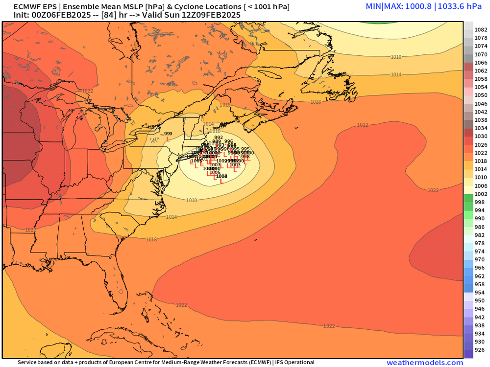
EPS really looked good for much of SNE and CNE
-
Yeah wouldn’t surprise me if the northern fronto band produces some weenie totals even if QPF stays under an inch. Like a foot on 0.75 or something.
-
Tracking February 6. Light to moderate event potential
ORH_wxman replied to Typhoon Tip's topic in New England
Looks like it tries to flip to snow in the heaviest stuff in NNJ…we’ll see if it gets some resistance as it tries to push east and northeast into the deeper arctic air.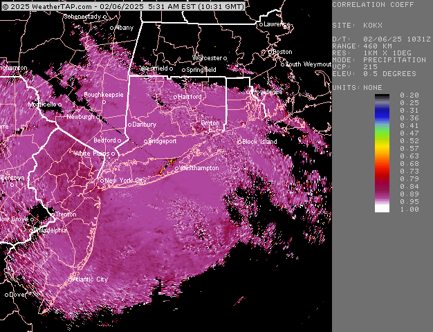
-
Solid arctic airmass. You could tell with how dry it felt. Not nearly as cold as up there but you could still tell this airmass has some bite to it when I was outside. It’s not even that weird of an airmass but it feels a little alien after the last two winters of mimicking Vancouver’s climate.
-
Tracking February 6. Light to moderate event potential
ORH_wxman replied to Typhoon Tip's topic in New England
At least if you don’t get much in this one, you weren’t missing much anyway with bigger things in the pipeline for the weekend. -
Gary Gray’s site was millennium weather (separate from any primitive forums back then). He was always a must-read before big storms. He used to post on here for a while actually. We always laughed when at the beginning of every update of his on millenniumwx, he’d start it by saying “I don’t have a lot of time right now so I’ll make this update brief…” and then he’d proceed to write a novel dissecting every single model solution.
-
18z euro is a solid hit again. Low end warning criteria for much of SNE and into CNE.
-
Yep I remember you all the way back then. Jspin too. Dendrite obviously. Then of course there were a whole bunch down in the mid-Atlantic too.
-
I think you started posting when you were still at PSU! Lol. I was just out of college. Crazy. Hopefully this stretch coming up can be another good one for the memory bank. We def got lucky during those first 10-15 years on the forums with some epic winters and epic storms.
-
Btw…..Happy 20 years of posting…I think you and I starting posting on Wright weather bulletin board (WWBB) around the same time…that epic 2004-05 winter. I had lurked previously but didn’t post until that winter. I remember seeing you show up and I started interacting with your posts. Jesus…20 fooking years…and some of the same peeps are still here from that era…Jerry, Ginxy, Kevin (CT Blizzard back then), Ryan, Bob, Tamarack, and several others I’m sure I missed. Fun times.
-
Yep, I’ll translate for those who don’t know 1= 0.1”-2.0” 2= 2-4” 4= 4-6” 6= 6-8” 8= 8”+ 8 is the highest it goes so if the model was predicting 20” of snow in that 12 hour period, it would still spit out an 8 on MOS
-
The crazy part is the pattern is still very weenie-ish at the end of the ensemble run too so you’d probably have more in the pipeline. Still gotta actually get these events to deliver but confidence is rising quickly.
-
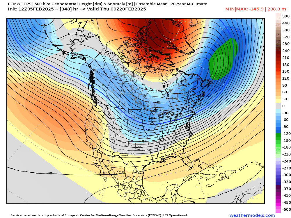
This is what it looks like at the end of the run…there’s still a lot of bullets in the chamber on that look..esp if we try and sneak some ridging out west