ORH_wxman
-
Posts
90,892 -
Joined
-
Last visited
Content Type
Profiles
Blogs
Forums
American Weather
Media Demo
Store
Gallery
Everything posted by ORH_wxman
-
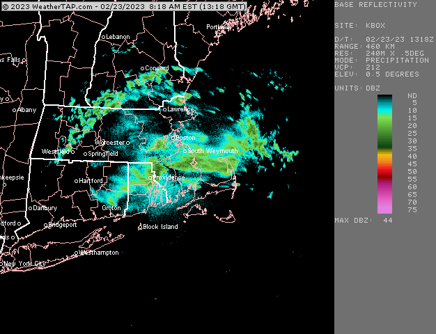
Yeah that is racing now. Lot of mesonets dropping like 3F in 30 min
-
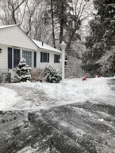
Maybe 1.5” of crud? It made bigger piles than 5-6” of fluff, lol
-
This stuff coming from the east is straight snow. Not a single pellet mixed in with this
-
Man snow (and sleet lol)
-
Feb 28th-March 1st long duration Miller B threat
ORH_wxman replied to George001's topic in New England
06z eps looking good. Maybe a little north of 00z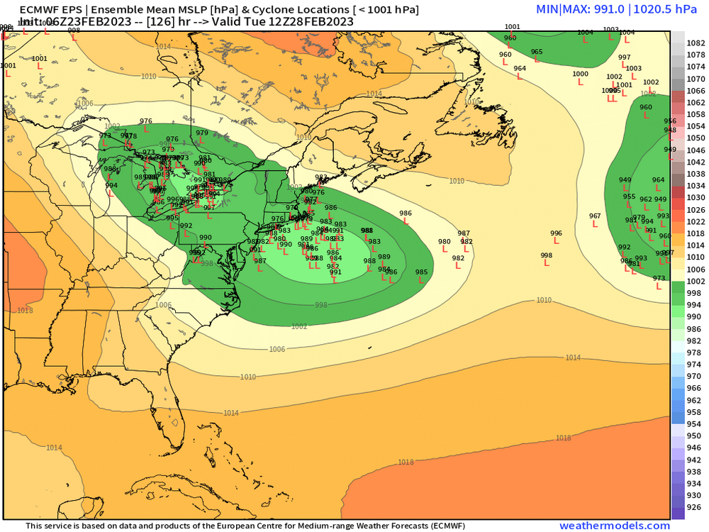
-
Steady light snow mixed with sleet. There’s a lot of dendrites in this stuff. Must be pretty cold below the warm layer with plenty of salt nuclei to produce this type of precip. Temp down to 29
-
Feb 28th-March 1st long duration Miller B threat
ORH_wxman replied to George001's topic in New England
GEM destroys BOS. -
Feb 28th-March 1st long duration Miller B threat
ORH_wxman replied to George001's topic in New England
Yeah the block is holding it north of Maine instead of allowing it to just march east. -
Feb 28th-March 1st long duration Miller B threat
ORH_wxman replied to George001's topic in New England
Rocky IV was on TV a couple nights ago so I was texting with scooter making fun of those analogies about winter. -
Feb 28th-March 1st long duration Miller B threat
ORH_wxman replied to George001's topic in New England
If Apollo Creed was winter 2022-23 and the -PNA was Drago, this storm is Rocky out for revenge. “I’m seeing change. If you can change, and I can change, this winter can still change!” -
Feb 28th-March 1st long duration Miller B threat
ORH_wxman replied to George001's topic in New England
Icon looks like it’s gonna be another fun solution -
1/27/11 was actually an A. Hit DC pretty good with thundersnow I remember. But it developed relatively slowly down south so it wasn’t maxing out down near DC. More like northern Mid-Atlantic into SE SNE.
-
Starting to get pavement stickage. Down to 31.5
-
Feb 28th-March 1st long duration Miller B threat
ORH_wxman replied to George001's topic in New England
I want to see this continue through 12z runs tomorrow before I start chucking weenies. The trend today was obviously very potent and that is meaningful, but there is still enough lead time that average model error from this point can still screw us. -
Feb 28th-March 1st long duration Miller B threat
ORH_wxman replied to George001's topic in New England
Block is pretty east-based on this storm. Not really worried about big suppression. -
Actually picking up here now. Good flakes and sticking to non-paved surfaces.
-
Your area is still pretty good in Bs though the skunk factor defin it let goes up in them there. But storms like Jan 2011 and Feb 2013 are great examples of crushing Bs there.
-
First weenie flakes here.
-
36/24 with snow imminent. Not expecting much though as radar looks like ka-ka. Might get a decent little burst here though over the next hour or two. Hopefully it fills in a bit.
-
I mean, it’s 5 days out on the 00z runs tonight (at least the onset). I don’t see how we don’t get this inside of 5 days. The main shortwave responsible for this is already onshore (at least partially) over the Pacific Northwest so we don’t have any major data assimilation issues for that part of it. I really think the two main factors are going to be the block (which has been slowly ticking stronger) and that second shortwave that tries to phase on the euro (doesn’t quite get there on GFS).
-
Feb 28th-March 1st long duration Miller B threat
ORH_wxman replied to George001's topic in New England
I’m letting George keep this thread under the condition that he’s banned if the storm shits the bed. -
Yeah if we’re getting buried on tomorrow’s 12z and especially 00z runs tomorrow night, then it might be time to start chucking them.
-
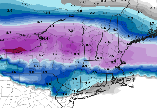
It's coming in slightly colder, but the biggest difference is it's ripping the rates much better than on earlier runs. It hammers for about 3-4 hours this evening. Other guidance has been pretty paltry with rates while it's still cold enough to snow up until you are north of NH border.
-
I remember I was doing a radio show on here (back when we had them) for that storm and I was looking at the 00z runs about 3 days before the storm and saying on the show "I think NYC might get annihilated....I know they are on the edge right now, but this monster deep ULL is almost in a perfect spot for them and the confluence to the north is going to great an insane band near the northern part right near where NYC is"....models eventually caught on to the idea, but I was jealous of that one there. It looked perfect on model guidance.
-
Rap gone wild north of the pike.