

ORH_wxman
-
Posts
93,099 -
Joined
-
Last visited
Content Type
Profiles
Blogs
Forums
American Weather
Media Demo
Store
Gallery
Everything posted by ORH_wxman
-
There are still huge fundamental differences in the northern stream....GFS kind of presses it down in the middle of the storm which mucks it up. GGEM has it ahead of the southern shortwave so it had a little room to operate.
-
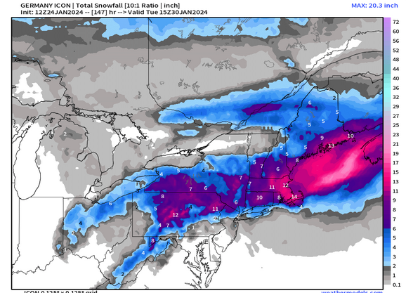
This is actually an interesting map to view vs the 10 to 1 I posted because you'll notice the 10 to 1 has higher amounts to the west but lower than Kuchera to the east....this shows how that CCB in eastern areas is when temps are crashing and much colder.
-
SE areas might have a bit more upside than some of the lower elevations further west because the CCB will get cranking and eventually turn very cold as it draws in that more arctic airmass....so even if you "Waste" the first half of the storm, you could go to pound-town for 6-10 hours during the CCB with big rates and much colder temps. It is still a needle-thread idea, but there is some upside there.
-
We ICON.... Ok, the real models should be coming out soon.
-
It was a Flop... February 2024 Disco. Thread
ORH_wxman replied to Prismshine Productions's topic in New England
MJO being super active has def hurt this winter. -
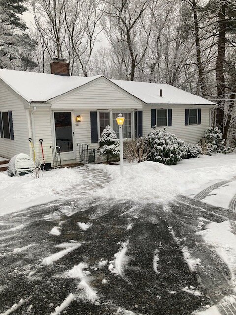
Very picturesque snow
-
Could be some coke lines OES later in the event as temps plummet. GFS has temps in the lower to mid 20s with OES at the end.
-
It was a Flop... February 2024 Disco. Thread
ORH_wxman replied to Prismshine Productions's topic in New England
Previous runs of EPS and GEFS had the wave dying in phase 6, now they both bring it into phase 8....been a theme all winter in the models trying to push it into the COD. -
Probably...you can see how there's a trailing "Tail" on the snow distribution on some of those bigger ones....it's also 10 to 1 maps so they will be overdone, esp in lower elevations. Hills over interior def have the best chance of good snows....I'm sure you'll be hoping MQE can triple your total.
-
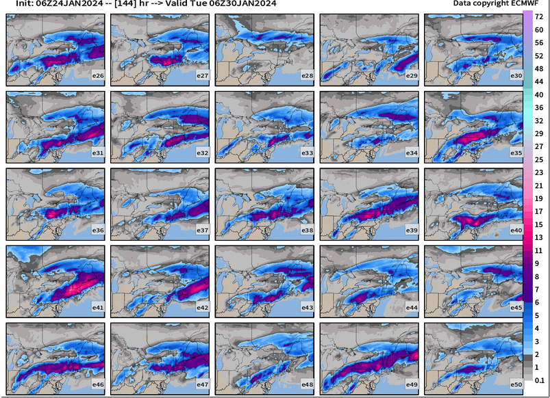
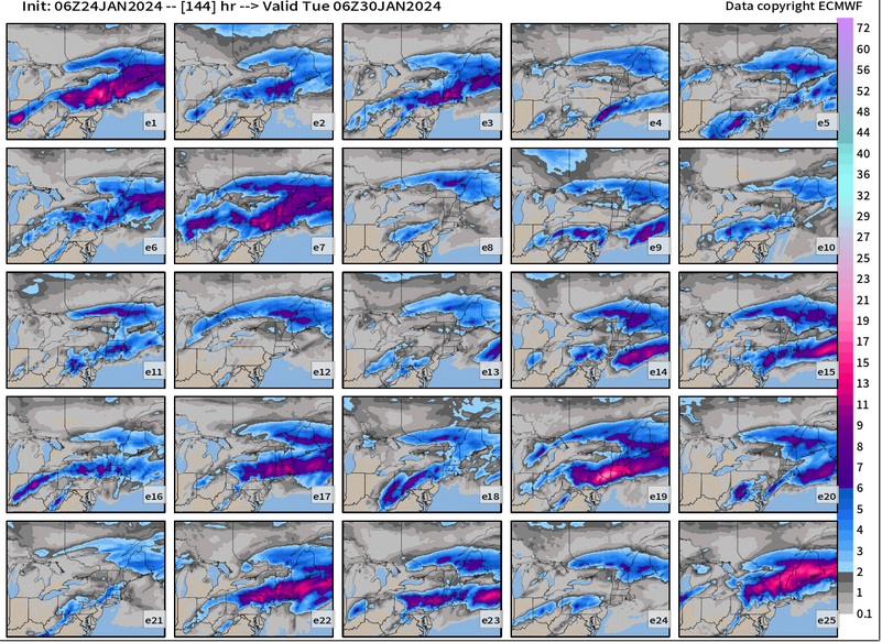
Still quite a few robust members on 06z EPS (that strip way up near Canadian border is from this week, so you can ignore that for this storm)....so I don't think this one is relegated to nuisance yet....it may still trend that way, but that's a good number of warning events.
-
Just taken to the woodshed by a beast of a man this winter. Hopefully we get a nice 128-495 special on Sunday….that will relax your mood a bit.
-
This actually looks colder than that one believe it or not. The one thing in that one though was the dynamics were very strong, esp in the first half of the storm. I want to see some better dynamics in this threat. A few model runs have had it but a lot more runs have been a bit disorganized.
-
They have a decent pack up there. Looks like there’s snow on them if you look closely. That pic has a color filter on it that makes everything look darker so the snow doesn’t stick out as much. Either that or the light was really weird near sunset or something.
-
12/5/20? Sounds like your description. ORH had a 10” paste bomb in that. We had like 3-4” here and further east had like 1-2”.
-
It doesn’t have to start as rain…and when I say start as rain, I don’t mean for the first 20-40 minutes while the boundary layer evaporationally cools. Yeah technically that counts as “starting as rain”, but it doesn’t really materially affect the storm totals. I mean for like several hours while we wait for heights/midlevel temps to crash. There are several version of this storm where we are already cold enough aloft to snow in the beginning.
-
Prob how disorganized it is. I don’t necessarily like that either because you won’t get good accumulation with that look. There’s plenty of time to make this more consolidated but I think we’ll want to see this trend better in the next 2-3 cycles to be more confident in anything over high end advisory.
-
It was a Flop... February 2024 Disco. Thread
ORH_wxman replied to Prismshine Productions's topic in New England
Only for that Feb 7-9 storm. But yeah kind of similar but this is more amped and there is a much more active STJ. But in that 2015 setup you had the western ridge temporarily shoved east into the central CONUS and it torched them but we had this little vortex of lower heights stuck just to our northeast and it was enough to keep us cold and have that overrunning system get us. I remember it was in the 70s down in VA/NC as well as a good chunk of the TN valley and plains during the early part of that multi-day event. -
It was a Flop... February 2024 Disco. Thread
ORH_wxman replied to Prismshine Productions's topic in New England
For those wondering why it matters a lot aside from just temps, note how the central ridge is poking well up into Canada near Hudson Bay. At the same time you have a strong PAC STJ undercutting it…if you stick a PV lobe near New England and the STJ is able to fully undercut the ridge…it goes from a ridge to a block over Canada and the colder air gets pinned southeast of it over our area…it almost acts as a defacto west-based NAO block. You start amplifying the STJ into that cold air and you have the recipe for a legit snowstorm. In the image above, the STJ hasn’t yet fully undercut the ridge yet but it’s close. That type of evolution is still not favored and my guess is we end up furnacing for a time, but if you do in fact manage the scenario above, the sensible wx difference is night and day. -
It was a Flop... February 2024 Disco. Thread
ORH_wxman replied to Prismshine Productions's topic in New England
@CoastalWx, OP Euro looking a little GFS-ish at the end. Still skeptical of full GFS but that was kind of a big difference.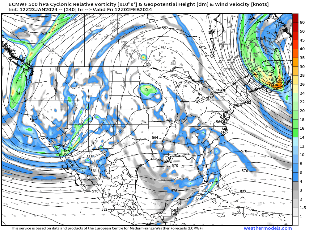
-
Yeah euro is a bit south. Still a good amount of spread on this system.
-
It was a Flop... February 2024 Disco. Thread
ORH_wxman replied to Prismshine Productions's topic in New England
Yeah the 00z run had us matching the EPS more but the 06z and 12z runs trended back to being cold while the rest of the country furnaces. I still think it’s probably wrong, but one thing to keep an eye on is a potential block up near the eastern Beaufort sea to the pole…it’s solidly further east than your normal EPO block but in this case, it acts somewhat similar except instead of the cold dumping into the Canadian prairies and plains, it is further east and comes almost straight down east of Hudson Bay and into Quebec and New England. -
Ukie looks pretty similar to GEFS. Maybe a bit south.
-
Let’s split the difference between that and the GFS.
-
GGEM looks a lot flatter than GFS through 108h.
-
00z OP was pretty zonked. Ensmebles were quite a bit south of the OP though.


