ORH_wxman
-
Posts
90,902 -
Joined
-
Last visited
Content Type
Profiles
Blogs
Forums
American Weather
Media Demo
Store
Gallery
Everything posted by ORH_wxman
-
Dec and Jan laid monster turds…but we did get a decent finish in second half of Feb and early Mar…we had several clippers/smaller events in late Feb and even early Mar before the bigger one on 3/4. Had good snow cover for well over a month from 2/12-onward. It would be nice to put together a good Dec/Jan combo for once. Haven’t had that in eons. 2017-18 was prob the last time.
-
That was a great storm because at least up in interior MA, it stuck around for over a week through Tday. I think I had 7.5” in that and it was pure powder until it was topped off with a little sleet before dryslot. What a frigid stretch that was and Tday itself was the coldest November day on record for a lot of New England sites.
-
Many of them also overperformed...the 2/2 event looked like a typical 6-10 SWFE until the RGEM kept insisting on faster redevelopment and continuing the snow all afternoon and it turned into a 12-18" for many. The overrunning storm from Feb 7-9 didn't really materialize on guidance until pretty close in (maybe 5 days out or closer?)....and of course we all remember the mid-level magic storm on 2/15 that was kind of a disaster on models.
-
What did HVN get in the 1/21/12 storm? I remember an intense band on the south coast while the rest of us got mostly crap advisory amounts.
-
Trying to show a weenie fronto band further north this run too into S VT/S NH.
-
Tracking February 6. Light to moderate event potential
ORH_wxman replied to Typhoon Tip's topic in New England
Slowly sinking south. We got to 31 but then now back to 28.5…but the real cold tuck is a little north just north of Sudbury and between 495 and 128 where it’s dropping into the low/mid 20s. Should try to push a little more in the next couple hours before weakening. -
Scooter is on tilt. He’s pulling out the Kevin reverse psychology or getting taken to the woodshed so many times since 2022 has turned him into Tblizz. Once he grabs 8-10 on the weekend he will be back to his normal self.
-
Yeah let’s rip 4 feet in February and then go March 2018 except not bust on two storms.
-
I remember the NAM used to show whiffs in 2007-08 on SWFEs when it was more than 48h out. Then it would amp up and get in line quickly once we were around 36h to go. GFS usually performed very well in SWFE back then but lousy in coastals.
-
Esp in eastern and southeastern areas....so you'd prob add more to those regions versus elsewhere.
-
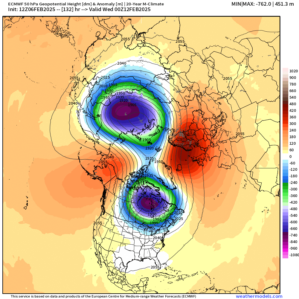
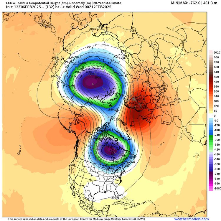
@CoastalWx and @40/70 Benchmark, 50mb split complete by D5 now. Looks like a lock. Wonder if we can prolong the blocking longer than weeklies think due to this.
-
It did bump north...still on the southern envelope but not as egregious as 12z. Synoptically, it actually has a really nice midlevel look from about the pike up into NH border region even though its not totally reflected on QPF.
-
Looks like NAM will come north at least some on this run based on 48h....not that it's worth much yet.
-
Tracking February 6. Light to moderate event potential
ORH_wxman replied to Typhoon Tip's topic in New England
1.1" of complete garbage in Holliston....started like dry cement....now its like half frozen wet cement. Temp has actually creeped up to 30.5F here. But might get a little cold tuck here in the next 3-5 hours. Closer to BOS might have to really watch for little mini-flash freeze. The HRRR shows it really well sloshing that Merrimack valley air in the low 20s back SSE. -
Early Feb 1994 and late Feb/early Mar 1960 are similar. The latter had a monster KU at the end of the pattern. I would say the pattern next week is most similar to 1994 with the SE ridge flexing, but it morphs more like 1960 in the week after that as the NAO/AO block really imposes its will.
-
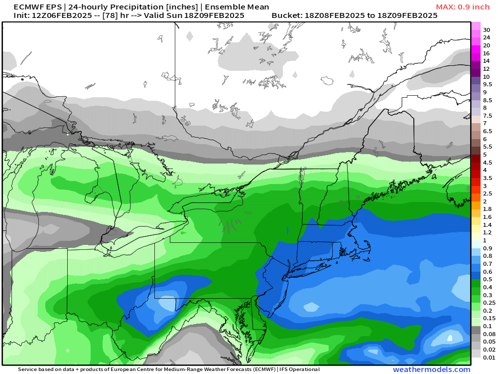
This was the EPS mean 24h QPF for this weekend....not a giant system, but that would be very solid...likely low end warning for much of the area in SNE.
-
It's definitely one of the most favorable patterns since 2015 (not that the bar has been set very high since that winter...maybe Mar 2018 would contend too)....but it's not really like 2015 itself. Different type of favorable pattern. 2015 was almost purely Pacific driven....it did have an occasional weak block in the Atlantic, but overall it was positive NAO. This is going to be a -NAO linking up with a -EPO ridge with a negative PNA and forming basically a north pole block.
-
Agreed....EPS mean still has around 0,75" QPF all snow for BOS...def a little more amped than the OP run. Still wouldn't be surprised at a tick north inside of 48 hours given the vort track....assuming it doesn't severely attenuate, but there's not been a sign of that happening on guidance.
-
OP Euro has threats every 3 days or so out to the end of the run. Not really a surprise given the pattern funneling everything toward us, but good to see it consistently showing up almost every run.
-
He was prob comparing to 06z EPS which was def south of 00z.
-
Ptype prob a bigger worry in the tristate area with vort tracking through BUF/ALB. It's prob good this is a touch south right now because I could see some north ticks here in the next day or two.
-
CT is prob the jackpot this run. But pike region looks very good too.
-
GGEM is ridiculous for next week in SNE. Solid moderate hit for Tuesday and then a major hit for Thursday.
-
Fast flow. You don’t get lingering storms…on the coast it might prolong a bit with the 925-850 flow trying to enhance things and almost an IVT look as it departs. But otherwise it’s a quick hitter. Best chance for prolonged snow is maybe we can get some prolonged overrunning next week for a time. But often it ends up focusing into a narrower window.
-
Tracking February 6. Light to moderate event potential
ORH_wxman replied to Typhoon Tip's topic in New England
It’s almost very fine pixie dust here rather than your classic loud pingers. Stuff out there is like dry cement consistency.