

ORH_wxman
-
Posts
90,892 -
Joined
-
Last visited
Content Type
Profiles
Blogs
Forums
American Weather
Media Demo
Store
Gallery
Everything posted by ORH_wxman
-
I'd sign on dotted line for that solution even though I flip to pellets. Really solid thump. Hopefully we start wobbling on the track now....don't want it to go further north.
-
While 2015 was pretty pedestrian in the CT Valley....1717 is probably the only semi-recorded year that can rival the 2015 blitz out east near Boston. 90-100 inches in a 23 day period....the 1717 blitz wasn't as much but it occurred in about half the time. Like 60-70" over 11 days, lol.
-
Feb 28th-March 1st long duration Miller B threat
ORH_wxman replied to George001's topic in New England
http://www.meteo.psu.edu/fxg1/NARR/1997/us1223.php (btw, that reference never gets old, lol) -
Feb 28th-March 1st long duration Miller B threat
ORH_wxman replied to George001's topic in New England
I might actually get warning snows out of this now...I was bracing for 3" 24 hours ago. -
Feb 28th-March 1st long duration Miller B threat
ORH_wxman replied to George001's topic in New England
Yeesh, that's a brutal job by the Euro...look at how different 00z run was -
Feb 28th-March 1st long duration Miller B threat
ORH_wxman replied to George001's topic in New England
Interior SE MA hills may do decent....that Foxborough/Sharon area with a few hundred feet. I think east slopes of ORH hills are going to do well tomorrow too as they will likely stay a tick below freezing with the elevation there. -
Looking a bit closer at better maps, Ukie trended a bit north, but the result didn't really seem to change much.
-
Ukie looks like it held serve from 00z...continues not to be quite as juicy as other models but it likes the idea of a low end warning event for most of SNE/CNE.
-
Feb 28th-March 1st long duration Miller B threat
ORH_wxman replied to George001's topic in New England
Yeah a lot of it will be beaten back on Wed/Thu...prob not all of it though. Obviously depends how much we get too...if we get 7", it's not all going away. But if we limp to 3 inches, then most of that might go. I still have about 2" of glacier here too, so there's going to be that underneath as well, so I doubt there's a lot of grass showing after Thursday outside of the sun-torched south/west slopes. -
This one kind of has 2/5/14 vibes....primary slamming into CLE but then hitting a wall of confluence in Quebec. But at this stage, 75 miles in either direction could produce large sensible wx differences than that 2014 event.
-
GGEM was really suppressed at 00z, so it's not a surprise it came north to be more in line with other guidance.
-
GGEM is a pretty huge hit for SNE...does tickle the sleet line about up to the pike but there's a pretty robust front ender prior to that down south of there.
-
Trailing shortwave regenerates snow.
-
There's still a large spread on how the NAO is handling the Quebec confluence to the north. I want to see that spread reduce some before getting confident in solutions.
-
GFS kitchen sink storm for SNE....front ender snow to sleet to ZR (interior...rain coast). Almost looks like a juicer version of 2/22-23
-
Feb 28th-March 1st long duration Miller B threat
ORH_wxman replied to George001's topic in New England
GFS def bumped up a bit in eastern areas -
Thursday could be a sneaky downslope dandy day prior to the cold trying to get in here ahead of the 3/4 system.
-
Feb 28th-March 1st long duration Miller B threat
ORH_wxman replied to George001's topic in New England
Here's the sounding for MBY on the 3k at 12 noon tomorrow....great look at how cold it is in the 900-950mb layer there.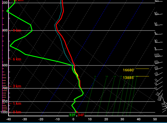
-
Feb 28th-March 1st long duration Miller B threat
ORH_wxman replied to George001's topic in New England
Good look on the IVT too....really on the 3k it shows it even better...esp for spots than can stay at or just below freezing. -
Feb 28th-March 1st long duration Miller B threat
ORH_wxman replied to George001's topic in New England
Top of MQE pasted while it's dripping off the trees below. -
Pattern looks pretty damned cold out into mid March and beyond. Maybe a *little* relaxation after the 3/4 storm but it looks to reload pretty quickly.
-
Feb 28th-March 1st long duration Miller B threat
ORH_wxman replied to George001's topic in New England
Yeah that’s actually a pretty solid forecast for us I think. I’d go advisory snows here with an outside shot at low end warning. -
Feb 28th-March 1st long duration Miller B threat
ORH_wxman replied to George001's topic in New England
06z euro did come back in a bit more juiced. Esp for CT where there was a pretty big bump in QPF. But everyone saw it come up a bit. -
Glad the north trended stopped. Good sign there. Still gotta get this inside 4 days though for more confidence.
-
Feb 28th-March 1st long duration Miller B threat
ORH_wxman replied to George001's topic in New England
ORH hills are gonna do well with the IVT stuff. It’ll prob be just cold enough there with the elevation to accumulate during the day. Prob the kind of thing where there’s a pretty big difference between 700-800 feet and 200 feet.


