ORH_wxman
-
Posts
90,892 -
Joined
-
Last visited
Content Type
Profiles
Blogs
Forums
American Weather
Media Demo
Store
Gallery
Everything posted by ORH_wxman
-
Das boot…drink up

-
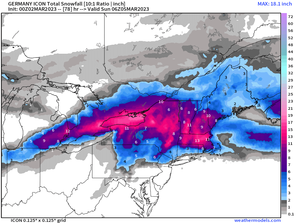
00z Reggie is a crush job N of pike.
-
3k hammered E MA for like 3 hours with 2” per hour…lol.
-
This actually may end up a little south of 18z. But it’s still pretty amped overall compared to other guidance
-
NAM looks really zonked again. So it won’t be that model caving at 00z
-
That was honestly one of the most ridiculous latitude gradients we’ve seen in seasonal snowfall. We were lucky we got to experience that one on the forums back in the day. Cant remember a winter that was more active than that one. I feel like MEkster and I were collaborating on forecasts nearly non-stop (back when I was forecasting full-time).
-
00z feels like a pretty big run…we got the bump warmer at 12z after 06z was cooling but then came back a little cooler at 18z on most runs.
-
Yeah that’s really blatant when you put the departures right next to BOS like that. ORH is almost exactly 2 warmer each month.
-
Yes. I’d be shocked if we don’t have some distinct moves by one camp by tomorrow morning. My guess is we’ll see some sort of compromise but the magnitude of that comprise matters a lot. If GFS wins 70/30, then you’re gonna get smoked, but if it loses 70/30, it’s pretty pedestrian.
-
The general consensus is around 400-500m. It can depend on rates though too and also what the peak temperature in that layer is. A 500m layer of 0.5C temps might not be enough but if the temp is getting to 1.5C in that layer, then it would be enough. That’s a pretty thin layer there but its def greater than 500m so it would be a sleet sounding.
-
The track of the ULL in the Midwest is the real key. On the GFS it keeps it south of the southern MI border into western OH. On runs like the NAM, it’s tracking into the thumb of MI. That’s a pretty big difference of 100+ miles.
-
That GFS CCB sig is crazy. It looks even better this run than 12z. I’m not buying into that yet but the persistence of that model has to be acknowledged. Esp since it’s one of the better models. We did see 18z reggie make a big nod toward it even if not quite all the way there. But the other guidance makes it hard to really buy into the idea.
-
I’ve already told everyone to expect a repeat of Mar ‘56.
-
There was also about a 10-12 foot storm surge in the FL Panhandle on the east side of that low. That’s almost unheard of for a non tropical cyclone.
-
Still on the colder side of guidance. Never really changes over north of CT/MA border.
-
In a sense, yes....at least late in the game....but we need it to not gain so much latitude earlier on. On the plus side....Reggie is trying to go full GFS at 18z...huge shift. Too bad it's not 2015 when it never missed a hanging curve.
-
Looked like it was digging the initial s/w more which causes it to want to rip N when it goes negative, but the confluence looked a little better well out to the east to it was forced to shoot eastward once it hit the brick wall.
-
The entire ridge/trough couplet in March 1993 was considerably larger than what the Euro is showing...and that's not to poo-poo the OP Euro look...that's a powderkeg look there....but Mar '93 was so ridiculous in the magnitude of it relative to the hemispheric pattern that it makes the D10 Euro look kind of paltry in comparison. Like March '93 wasn't playing around with the blocky look we have here...it was just simply including the PV into the trough axis
-
18z NAM actually crunched the low eastward quicker than 12z despite initially being further north. Something to watch on future runs...if that process happens a little faster, you start ending up pretty snowy quickly...like I said earlier with the QPF too, it's sort of non-linear.
-
The ORH record is bogus....since ASOS has been running consistently about 2F warm. It's still roughly a top 5 warmest winter though there, just not truly warmer than 2001-2002.
-
The ageo flow isn't as good as the 2/23 event so I don't expect a lot of prolonged icing like you had in that one. We might be able to get a little more snow on the front end than that one had....we'll see though. Prob more sleet in this system too.
-
Gets pretty far north on Euro....but yeah youll see a sharp cutoff on the northeast side due to the blocking shoving everything east once it reaches a certian point.
-
There's a non-linear response to the QPF too....when we get this thing swinging up west a bit, it basically prevents the WCB from really tapping into the Atlantic and crushing us. When it's a bit further east/south, it really goes to town.
-
This thing def hits a brick wall and goes due east....we just gotta hope it does it slightly sooner than the 12z runs were showing.
-
Euro def gonna be north of 06z