

ORH_wxman
-
Posts
90,892 -
Joined
-
Last visited
Content Type
Profiles
Blogs
Forums
American Weather
Media Demo
Store
Gallery
Everything posted by ORH_wxman
-
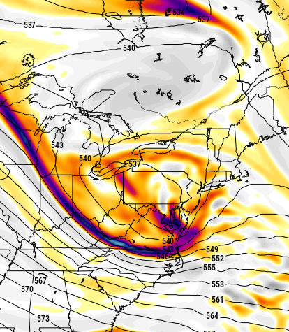
EPS might like the 2nd wave more than the first one, kind of like the OP.
-
Nice Ray jackpot. Anyways, total clown range on that one...we'll see how the 3/11 deal trends as that will impact anything behind it most likely.
-
Yeah it's going to try and amplify the trailing energy now that round 1 was pretty weak.
-
I'll be shocked if the Euro doesn't whiff southeast this run...looks super compressed/blocky.
-
It's only the GFS that tucked it....we have 2 whiffs southeast this 12z suite too (Ukie/GGEM)....There's still plenty of variance in model solutions at the moment despite getting a little bit more clarity in the past 12-24 hours.
-
Well the GGEM did something similar...its the inability for the shortwave/ULL to produce sufficient downstream ridging to curl this thing northward....look at the heights on the eastern fringe there...they are going south in Maine and trying to go north near ACK....they can't get any further north because of that confluence. Need just a little more room.
-
Ukie having the same trend out west. Clearly this is something all 12z guidance sees. Every single model at 12z has had the same trend out west of amplifying that ridge a little more with a bit more wave spacing. That is good because it increases the upside in this storm if we're looking for a big dog. (the storm actually whiffs us south on the Ukie...but that is mostly irrelevant at the moment)
-
This will be a big interior hit this run...kind of tucky...but obviously we're not worried about details yet. I like the ridge trend this run out west.
-
I'm a lot more interested in H5 than the sfc presentation at the moment anyway....we know how the skill degrades on model guidance as we go toward the sfc...esp further out in time.
-
Little extra wave spacing makes all the difference...lets that thing go to town just south of us.
-
ICON went wild that run.
-
Taken with a grain of salt for now...but the trend of the JV models at 12z seems to be burying the trailing energy offshore a little west which is helping the ridging in between the two. We'll see if the varsity team follows suit.
-
I feel like every neighborhood has a place like that. There's a house around the corner from me that will do the exact same thing you describe....my front yard has some protection from afternoon sun, so it can take a while to melt out, but this guy literally might take an extra week to melt out. His yard just doesn't get any sun at all except early morning between around 7-10am and then it's nothing the rest of the day. It will look ridiculous sometimes when the entire street is melted out except piles/patches and this guy literally has like a 4-6" level snowpack covering the entire lawn.
-
Latitude has mattered more than elevation this winter even though in many events, elevation helped a lot....but it only helped when the mid-level temps were cold enough. The persistence of it has been pretty unusual but it does happen once in a while. We had a decent number of winters recently where ORH was absolutely crushing areas like Leominster/Lancaster/Bolton/Clinton/Shirley despite only averaging a few more inches than they do per winter....we were kind of due for one of these to regress things back toward longer term relative climo comparing each location to eachother.
-
In March 2001, I remember later that month you'd have south facing steep slopes completely bare while an open flat field had literally about 27-30 inches of pack and in the woods, it was still over 3 feet. One of the more egregious examples I've seen of late season snow pack differences just based on proximity/angle/exposure to the March sun.
-
I'd bet Clinton at 340 feet averages less snow than your old place in ORH at 660 feet....though it's probably close. This winter has just seen an unusually steep latitude gradient on several storms.
-
Kind of an interesting model battle....GFS suite has been more amped while Euro suite has been a little suppressed. Often see it the other way around in these systems.
-
He’s in SE MA so for us over the interior, we don’t count.
-
Yeah I’m not sure where the “spiking the football” narrative is coming from. The storm is still very much a possibility and I think the trends on ensembles have been generally positive the last day or two. That’s all you can really say at day 7. People are going to discuss threats. It doesn’t mean they pan out. If they always did, we wouldn’t dissect model guidance. We’d just take it at face value.
-
That area has been crushed the last couple weeks.
-
It’s possible but a needle threader. Could easily be crunched south or end up too warm like the 18z NAM.
-
Yep. And I’d expect that if people do not want to worry about the storm until closer, take a break from this particular thread and come back in 3 days. For those who enjoy tracking the changes or watching guidance slowly converge on solutions, then that’s what the thread is for.
-
EPS is kind of halfway between a “minnesota squeeze” (to steal Tip’s phrase) and a more conventional Miller B. Still a lot of be ironed out in the evolution
-
No he just means they are overdone. Esp in lower elevations. It would be snow but prob more like 7 or 8 to 1 paste outside of the hills.
-
OP runs mostly meaningless but the larger ensemble suite of guidance seems pretty decent today. Still a lot of time.


