ORH_wxman
-
Posts
90,892 -
Joined
-
Last visited
Content Type
Profiles
Blogs
Forums
American Weather
Media Demo
Store
Gallery
Everything posted by ORH_wxman
-
The last hurrah? Putting all the eggs in the Tuesday 3/14 basket
ORH_wxman replied to Ginx snewx's topic in New England
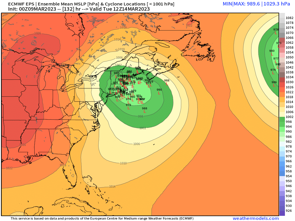
Takes a nice trajectory...just outside 70W and then pulled NNW to the position near ACK/MVY. -
The last hurrah? Putting all the eggs in the Tuesday 3/14 basket
ORH_wxman replied to Ginx snewx's topic in New England
Captured near MVY -
March 10-11 light snow threat for SW New England.
ORH_wxman replied to Sey-Mour Snow's topic in New England
Euro juiced up again....large area of >0.50" QPF in CT. -
The last hurrah? Putting all the eggs in the Tuesday 3/14 basket
ORH_wxman replied to Ginx snewx's topic in New England
You'll be back for the 3/18 and 3/23 threats. -
March 10-11 light snow threat for SW New England.
ORH_wxman replied to Sey-Mour Snow's topic in New England
12z doesnt come out for another 20-25 min or so. But 00z and 06z kept ramping up. 00z and 06z were fairly similar though 06z was better in eastern SNE than 00z was. Pretty much same in W CT. -
The last hurrah? Putting all the eggs in the Tuesday 3/14 basket
ORH_wxman replied to Ginx snewx's topic in New England
Ukie almost pulled it off. -
The last hurrah? Putting all the eggs in the Tuesday 3/14 basket
ORH_wxman replied to Ginx snewx's topic in New England
Almost reminds me of the Mar 2013 firehose with that 600 mile long fetch of easterly 850s, lol. It's a little displaced south though. But just another solution....that was really close to being a monster hit. -
March 10-11 light snow threat for SW New England.
ORH_wxman replied to Sey-Mour Snow's topic in New England
Deepening ULLs going underneath New England are always intriguing, so we watch for surprises. -
The last hurrah? Putting all the eggs in the Tuesday 3/14 basket
ORH_wxman replied to Ginx snewx's topic in New England
Yes....GFS was really shallow with the northenr stream too...I think if we had dug the northern stream just a touch more on the GFS, we could have achieved an EPS-esque solution. -
March 10-11 light snow threat for SW New England.
ORH_wxman replied to Sey-Mour Snow's topic in New England
Maybe....but it can't really claim as much of a win as it might have if it never waivered....it went completely to the Euro idea by yesterday's runs only to come back AFTER the Euro came back north at 18z. But yeah, if this comes in another tick amped, then its original idea from like D4-5 will end up not far off. It just didn't stick to its guns. -
The last hurrah? Putting all the eggs in the Tuesday 3/14 basket
ORH_wxman replied to Ginx snewx's topic in New England
Yep...what we want is the southern vort to outrun the northern shortwave by enough so that by the time the northern catches up to it, the low is taking a wide turn and then gets ripped back north along like 70W and back toward ACK. We don't want that process to start earlier like what happens on the GGEM and ICON because then you just rip the low over eastern MA. -
The last hurrah? Putting all the eggs in the Tuesday 3/14 basket
ORH_wxman replied to Ginx snewx's topic in New England
Almost a non-storm on the GFS....gets some heavier precip in there via the IVT but this is probably similar to those lows we see on the ensemble clusters that are well southeast. -
March 10-11 light snow threat for SW New England.
ORH_wxman replied to Sey-Mour Snow's topic in New England
It wouldn't take that much more amplification of the upper air low to start wrapping a CCB around this whole thing. Getting dangerously close to a full blown storm with that upper air look.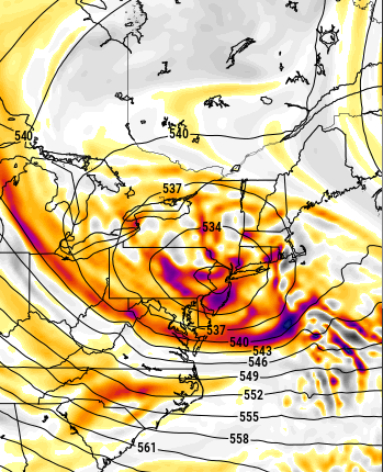
-
March 10-11 light snow threat for SW New England.
ORH_wxman replied to Sey-Mour Snow's topic in New England
GFS gone wild for CT -
The last hurrah? Putting all the eggs in the Tuesday 3/14 basket
ORH_wxman replied to Ginx snewx's topic in New England
First JV model that can see the storm today (ICON) brings it over E MA....obviously not very good for most of SNE...though ORH county to Berkshires and NW CT do quite well on that run with the jackpot from Catskills to NW MA taconics to buried bodies in S VT. -
March 10-11 light snow threat for SW New England.
ORH_wxman replied to Sey-Mour Snow's topic in New England
It's like -1C at 925...it's gonna be pretty pasty. -
Heh, there are old hard copy pics but likely in storage down in Texas with all my dad's stuff (he's living abroad at the moment). If I get a hold of them again I'll def scan them because they were pretty cool to look at. Though these days, you can find similar all over social media with what's going on out there right now.
-
I personally saw near 20 feet OTG there back in Mar 1999. It's weird to experience...almost like you're in some weird fantasy land that isn't real. I'm sure it's the same feeling for people going into ice caves or scuba diving....different world from the normal reality we deal with. The 6-7 foot snow packs we will see on the slopes of new england are big, but they don't feel unreal like when you are walking around with snow canyons 3 times your height next to you which is what I was doing in March 1999.
-
The last hurrah? Putting all the eggs in the Tuesday 3/14 basket
ORH_wxman replied to Ginx snewx's topic in New England
Yeah wait until at least Saturday, lol....this could be ripping up the CT valley for all we know by tomorrow. If we keep the general model clustering close to the BM/outer Cape region today, then I'd start to get a little more confident, but we're still in that precarious window at D4.5ish -
Yeah some of those early-era ASOS QPF numbers are awful.They've gotten a lot better but still not ideal.
-
The last hurrah? Putting all the eggs in the Tuesday 3/14 basket
ORH_wxman replied to Ginx snewx's topic in New England
Yeah I'm technically east of 495 but very close to it...and some other spots with a little bit of elevation too. -
The last hurrah? Putting all the eggs in the Tuesday 3/14 basket
ORH_wxman replied to Ginx snewx's topic in New England
Yeah this is related to the discussion I had yesterday on why Feb 2013 was so prolific and also didn't have a lot of violent model swings once the non-Euro guidance caught onto it....it had a fairly fresh polar high to the north (I wouldn't call it arctic, but solid polar airmass) and this provided some real resistance to any potential westward moves in addition to obviously locking in the BL cold. The high providing resistance also increased the ML fronto in that storm which helps make it more prolific in snow totals. That not being present in this system means we're hoping for the ideal track. Like you said, I'm hoping as we get closer, maybe we see a little bit more resistance...it's not going to look like a Feb 2013 high, but even marginally more resistance goes a long way in areas that are progged to be marginal in this. Even a psuedo-decaying high sliding east of Houlton ME would be a little bit useful. -
The last hurrah? Putting all the eggs in the Tuesday 3/14 basket
ORH_wxman replied to Ginx snewx's topic in New England
06z run got rid of most of the interior MA tracks looking at the clusters.
-
The last hurrah? Putting all the eggs in the Tuesday 3/14 basket
ORH_wxman replied to Ginx snewx's topic in New England
06z EPS is def a bit SE of 00z (don't worry, I made sure I was toggling the right frames this time...lol) -
The last hurrah? Putting all the eggs in the Tuesday 3/14 basket
ORH_wxman replied to Ginx snewx's topic in New England
Yeah my guess is that would end up a little more subdued than 00z....we'll see what EPS says in a bit.