

ORH_wxman
-
Posts
93,092 -
Joined
-
Last visited
Content Type
Profiles
Blogs
Forums
American Weather
Media Demo
Store
Gallery
Everything posted by ORH_wxman
-
It was a Flop... February 2024 Disco. Thread
ORH_wxman replied to Prismshine Productions's topic in New England
Yeah you are correct the heatwaves were longer back then and max temps more extreme. I think at least part of it was the drought conditions across the central US and esp south-central US and the drought extended up into the northeast, just a bit less intense than to the southwest. Drought keeps dewpoints down and it’s easy to sore in the summertime when you have dry air. CC might make this harder to come by if we are getting more high-dewpoint summers. But it’s also possible if we do enter a drought at some point anyway, things could be even hotter now. -
It was a Flop... February 2024 Disco. Thread
ORH_wxman replied to Prismshine Productions's topic in New England
There was definitely a period of extreme warmth in the northeast during the late ‘40s/early ‘50s. I think 1949 is still the warmest year on record for many stations in MA. That warmth extended up into gulf of maine and the Canadian maritimes….so clearly there was something going on during those years that may have helped tropical cyclones get northward. But it’s an interesting question why we haven’t been able to get the same thing now with big warmth being centered over that same area in the past decade. -
It was a Flop... February 2024 Disco. Thread
ORH_wxman replied to Prismshine Productions's topic in New England
Agreed. @bluewave is a very good poster. He’s here in good faith. -
It was a Flop... February 2024 Disco. Thread
ORH_wxman replied to Prismshine Productions's topic in New England
Sneaky snowy pattern coming up for the upslope areas the next week or so. Hopefully that helps up there. -
It was a Flop... February 2024 Disco. Thread
ORH_wxman replied to Prismshine Productions's topic in New England
You could argue we’ve seen less EMLs (elevated mixed layer) than we used to if we’re getting more western Atlantic ridging in the summer giving us higher dewpoint airmasses. I don’t know if that’s true long term or empirically speaking but anecdotally it seems to be the case in recent years. What we typically want for severe wx in the northeast is an EML that comes over the top from the plains and Great Lakes….they actually originate in the semi-arid climate of the southwest and western plains. Without an EML, it’s a lot harder to get high end severe wx…you need those big lapse rates. -
It was a Flop... February 2024 Disco. Thread
ORH_wxman replied to Prismshine Productions's topic in New England
Yeah it would make an interesting study. It’s too bad we don’t have better data from that period. The late 1800s was also another period of frequent TC activity along the east coast. But it doesn’t quite match that 1930s-1960 period. -
Most of New England has a very weak correlation to ENSO when it comes to snowfall. Weak El Niño is the best ENSO state but you see big snows in many other ENSO states as well. George is correct that a very potent El Niño is prob the worst. It typically comes down to other factors here. You can have a potent La Niña with little blocking and still be good (07-08 is a good example) but also an awful potent La Niña with little blocking (1999-00 comes to mind).
-
It was a Flop... February 2024 Disco. Thread
ORH_wxman replied to Prismshine Productions's topic in New England
I’m pretty sure the last major hurricane landfall north of Cape Hatteras was Edna on the Cape in 1954…ironically right before that was another cat 3 that was even stronger and that was hurricane Carol when it made landfall in RI. -
It was a Flop... February 2024 Disco. Thread
ORH_wxman replied to Prismshine Productions's topic in New England
I’m more interested in actual truth than arguing politics and “which side is worse”. This is a weather forum and we’re interested in what the weather is going to be. The problem with most of the climate change debate in the context of a weather forum is that it doesn’t provide much (if any) use in operational forecasting outside of leaning warmer in seasonal outlooks absent all other info. It tells me nothing about the prospects of next week’s snow chances and tells us nothing about the chances of getting a severe wx outbreak up here this spring. There’s been an increase of memory-holing of historical weather events in recent years and it’s not a good way to increase our weather knowledge. I don’t even want to know what we’re going to hear when we get another 1930s-1950s tropical cyclone period in the North Atlantic. -
It was a Flop... February 2024 Disco. Thread
ORH_wxman replied to Prismshine Productions's topic in New England
I don’t really have an issue with most of his posts. He’s a bit more nuanced than some of the CC zealots. My biggest disagreement with him was about blocking staying further south semi-permanently going forward due to Atlantic SSTs…. The MJO stuff is an interesting theory but I still lean on it being over-attributed just like many of the other factors that were presented prior. He does mention it could reverse which is more than others have said. Having record warmth is definitely easier due to CC because the globe is warmer. No arguing that. You’re always going to get some weird and anomalous streaks…and the easiest explanation is going to be CC and people will ride that whether the attribution was like 10% or 20% or 80%. -
It was a Flop... February 2024 Disco. Thread
ORH_wxman replied to Prismshine Productions's topic in New England
South coast especially should keep an eye on Saturday. I was looking at that a little closer it’s now and aloft looks like it could produce a decent band of snow there. Right now, the system is struggling with a pretty rounded base of the trough but if that sharpens just a hint, than you’d see a pretty nice stripe of snow over southern areas. -
It was a Flop... February 2024 Disco. Thread
ORH_wxman replied to Prismshine Productions's topic in New England
If you’re getting huge omega in the DGZ like some of these runs show, it’s how you’d get a 6” fluff bomb from like a quarter inch of QPF. Maine foothills are as good a place as any to get that type of system in any given winter. -
It was a Flop... February 2024 Disco. Thread
ORH_wxman replied to Prismshine Productions's topic in New England
NAM has a nice crosshair sig tomorrow night over pike region (haven't checked other areas really)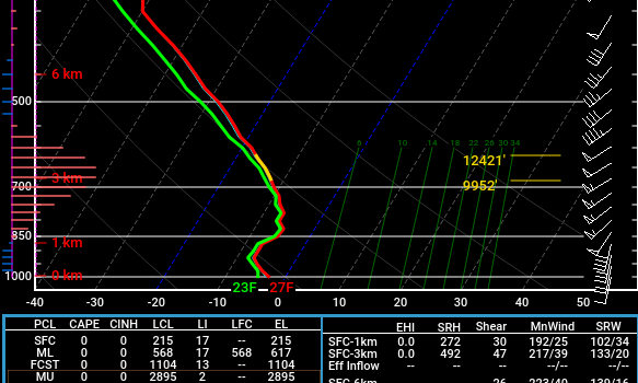
-
It was a Flop... February 2024 Disco. Thread
ORH_wxman replied to Prismshine Productions's topic in New England
MJO is the latest fad to explain a small sample size of outcomes IMHO. We’ve seen it for decades now. - Late 1990s literature blamed the big reversal of NAO/AO to predominately positive phases on CC -early 2010s literature blamed the big flip back to -AO/NAO on CC via melting sea ice - mid-2010s literature blamed the western drought and cold eastern winters in the pacific warm blob due to CC I remember being called a climate denier for being skeptical of the sea ice theory circa 2012 or so. It’s hard to have rational discussions about these attribution studies with people who don’t really care about rigor. MJO is popular right now because “it makes sense” in explaining a small sample of shit winters in the east. To your point, maybe the MJO stuff is true in a vacuum but people are over-attributing the MJO to our own weather. What is going to be the next explanation when we get a couple of cold-loses winters in a row? -
It was a Flop... February 2024 Disco. Thread
ORH_wxman replied to Prismshine Productions's topic in New England
2015: “the west coast pacific warm blob isn’t going to magically cool” 2024: “the tropical pacific warm blob isn’t going to magically cool” -
It was a Flop... February 2024 Disco. Thread
ORH_wxman replied to Prismshine Productions's topic in New England
Our biggest problem in the past two years is windows of favoribility have been short. Yeah, we also got unlucky when they did occur and we got skunked, but being able to take 4 or 5 shots at a pattern is way better than 1 or 2. The composite of the past 3 winters (if you include this one so far) has put the highest heights over the eastern US. It’s the exact opposite of what you’d want to see to get plentiful chances at snow events. -
It was a Flop... February 2024 Disco. Thread
ORH_wxman replied to Prismshine Productions's topic in New England
I agree there was a signal for a storm. You had a thread on it well prior to it becoming very cohesive on guidance. But it was prior to getting a good airmass in here…sort of the leading edge of the pattern shift. Seems our biggest problem going forward is now not being able to time any features together in the longwave pattern to produce a larger scale winter storm…there’s always something mucking it up whether it’s shortwave spacing or the longwave pattern itself breaking down after short intervals of favoribility. -
It was a Flop... February 2024 Disco. Thread
ORH_wxman replied to Prismshine Productions's topic in New England
If the goal is just a good snow event, there’s a lot of patterns it can occur in…but ideal or “epic” patterns just make them more likely. The irony about this event yesterday on 2/13 was that it was really prior to the pattern getting good. It was considered gravy if we got anything out of it. -
Bluebird sky out there this morning…with strong CAA at least it looks and feels like winter out there today.
-
It was a Flop... February 2024 Disco. Thread
ORH_wxman replied to Prismshine Productions's topic in New England
It’s going to be a relatively fast band of snow for anyone south of MA/NH border because we’re south of the low track…so we’ll get the WAA burst in front of it and then it dryslots. But yeah, some of these soundings look nice and if they continue to look like that tomorrow, then I could see a quick 2” in spots. But it could also end up a bit shredded if that vort trends a little north. We want to root for that vort to dig a little more -
It was a Flop... February 2024 Disco. Thread
ORH_wxman replied to Prismshine Productions's topic in New England
Yeah I’d be a little bit surprised if you didn’t…assuming it doesn’t trend worse in the next 24h like most other systems this year. Too bad we’re all jaded at this point in a shit winter…this is the type of system we’d be semi-excited about if it was progged for December 15th instead of February 15th. -
It was a Flop... February 2024 Disco. Thread
ORH_wxman replied to Prismshine Productions's topic in New England
GFS actually has a nice burst of omega right in the DGZ tomorrow night over MA including BOS. I don’t know if it’s correct but that would prob drop a couple inches. NAM has a similar look on the soundings but a bit more paltry on QPF. -
It was a Flop... February 2024 Disco. Thread
ORH_wxman replied to Prismshine Productions's topic in New England
Yeah I’m not expecting much from the clipper down here. Maybe an inch or so if lucky. Vort track is pretty solid for CNE/NNE though so someone will do 2-3” with spot 4” up there I think. -
It was a Flop... February 2024 Disco. Thread
ORH_wxman replied to Prismshine Productions's topic in New England
Flow goes very meridional for a time so that’s the period to watch imho. Model guidance tends to struggle the most when you have northern stream shortwaves coming out of the arctic where sampling is bad and satellite data is distorted. That’s when we can get those threats to pop out of nowhere at like D5-6 -
It was a Flop... February 2024 Disco. Thread
ORH_wxman replied to Prismshine Productions's topic in New England
You’ll be right back on the train once the clown maps have you in double digits on the next threat.


