ORH_wxman
-
Posts
90,892 -
Joined
-
Last visited
Content Type
Profiles
Blogs
Forums
American Weather
Media Demo
Store
Gallery
Everything posted by ORH_wxman
-
The last hurrah? Putting all the eggs in the Tuesday 3/14 basket
ORH_wxman replied to Ginx snewx's topic in New England
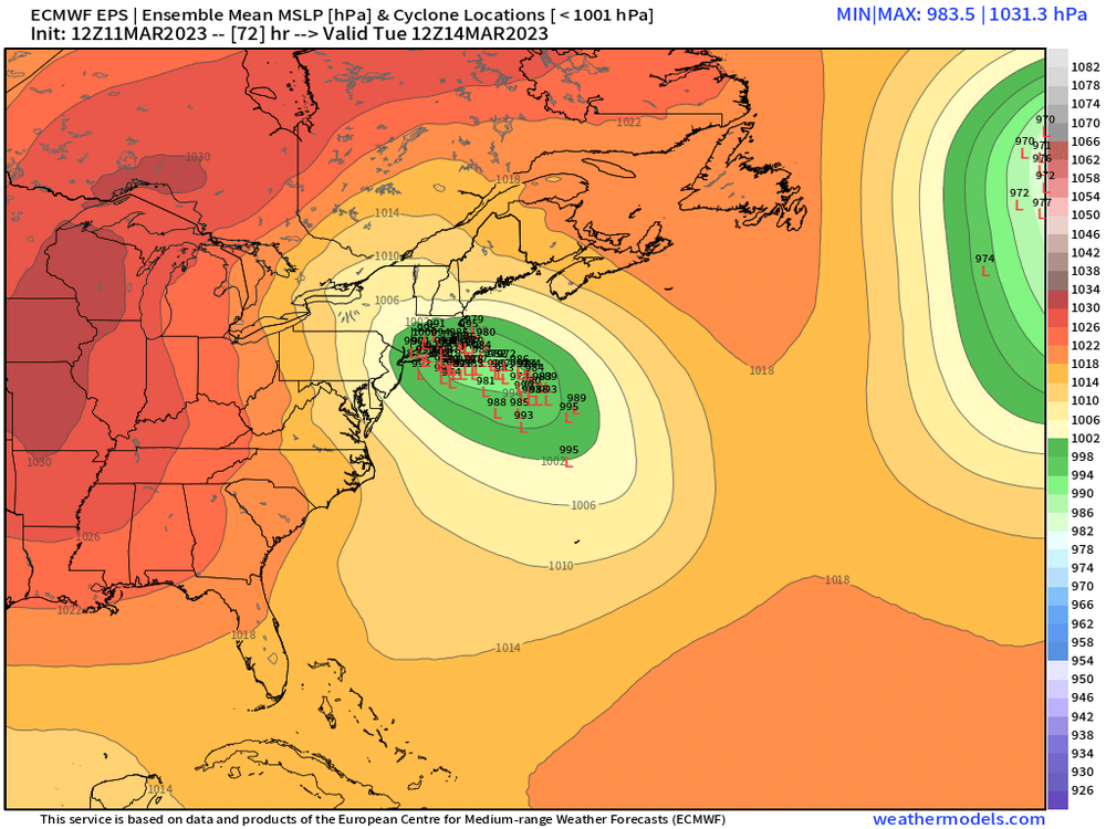
Lot of seaward members on EPS taking a wide turn. But they do start consolidating closer to the cape on the next couple frames.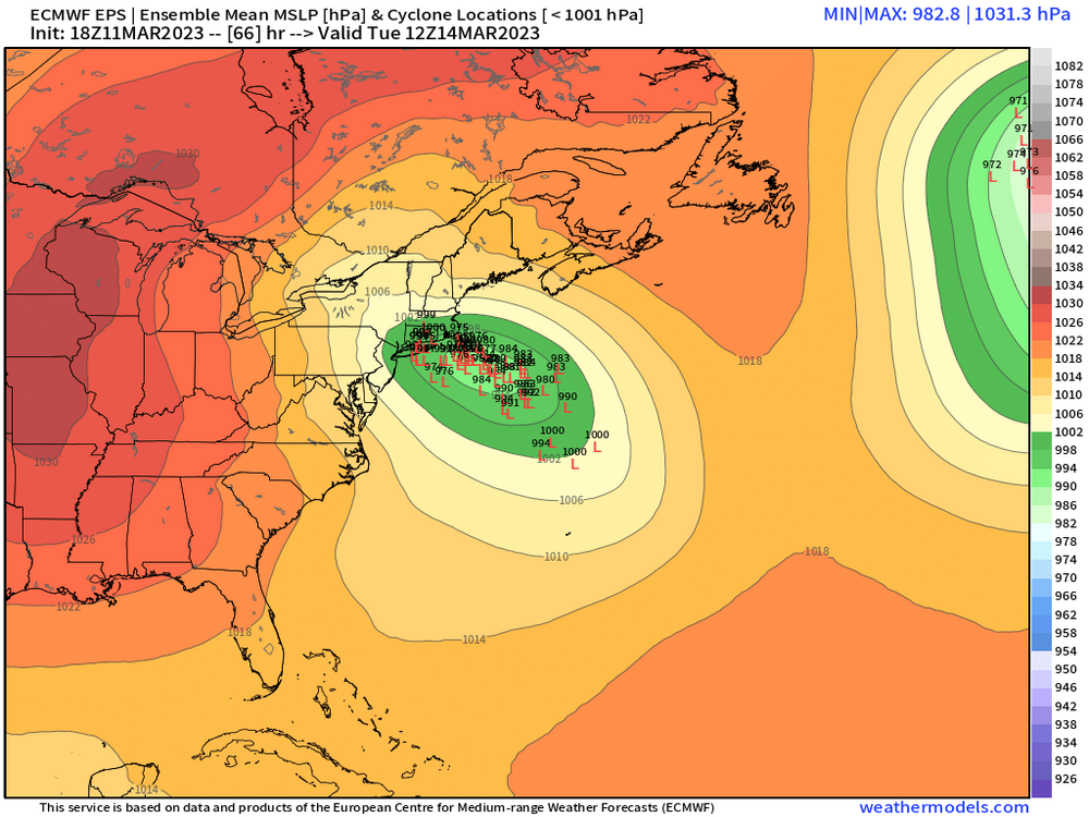

-
The last hurrah? Putting all the eggs in the Tuesday 3/14 basket
ORH_wxman replied to Ginx snewx's topic in New England
Yes once you see those 925s collapse in the CCB, the profile gets easily cold enough for snow at least away from the water. I do think places in CT that are getting a lot of WCB precip prior to the CCB need to look at the soundings very carefully. -
The last hurrah? Putting all the eggs in the Tuesday 3/14 basket
ORH_wxman replied to Ginx snewx's topic in New England
Not super similar but some of the variables are…Dec ‘92 had a strong ULL diving down through VA and this one comes in further north but due to the eastern southern stream low, we end up with an easterly flow for a time that is somewhat similar. Dec ‘92 had a potent high pressure up north too which while not very cold, it really increased the pressure gradient and helped cause the huge winds (90+ mph gusts on the exposed shore) Airmass was pretty marginal in Dec ‘92 as well -
The last hurrah? Putting all the eggs in the Tuesday 3/14 basket
ORH_wxman replied to Ginx snewx's topic in New England
Tomorrow technically since we don’t turn clocks forward until 2am -
The last hurrah? Putting all the eggs in the Tuesday 3/14 basket
ORH_wxman replied to Ginx snewx's topic in New England
Still ends up getting you eventually. Lol. But yeah, guidance has to figure this crap out with the phasing. -
The last hurrah? Putting all the eggs in the Tuesday 3/14 basket
ORH_wxman replied to Ginx snewx's topic in New England
GFS has a stronger primary this run. IVT will be an issue this solution. -
The last hurrah? Putting all the eggs in the Tuesday 3/14 basket
ORH_wxman replied to Ginx snewx's topic in New England
18z Icon still has a dual low with the western one going into ginxys hood. No good for most of SNE. -
The last hurrah? Putting all the eggs in the Tuesday 3/14 basket
ORH_wxman replied to Ginx snewx's topic in New England
There’s a reason we call them clown maps. They are fun to look at but they aren’t reality. They can be ok in uniform storms with a cold thermal profile but otherwise you need to really look at soundings and midlevels. -
The last hurrah? Putting all the eggs in the Tuesday 3/14 basket
ORH_wxman replied to Ginx snewx's topic in New England
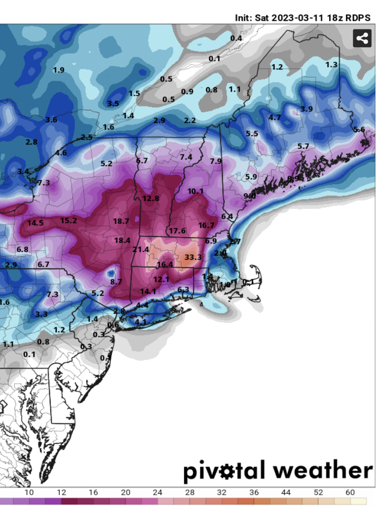
10 to 1 is April 97 for ORH.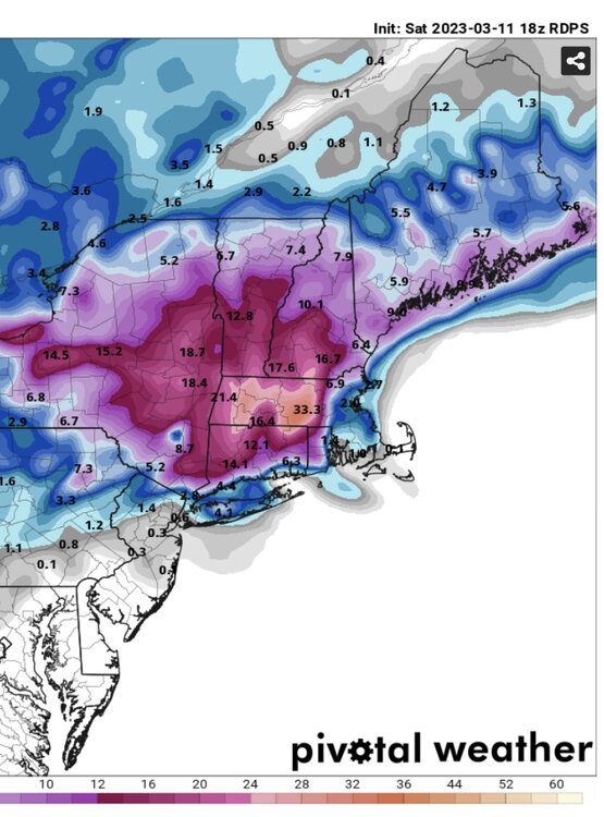
-
The last hurrah? Putting all the eggs in the Tuesday 3/14 basket
ORH_wxman replied to Ginx snewx's topic in New England
Upper cape and then drifts east -
The last hurrah? Putting all the eggs in the Tuesday 3/14 basket
ORH_wxman replied to Ginx snewx's topic in New England
Reggie is annihilation over interior SNE. -
The last hurrah? Putting all the eggs in the Tuesday 3/14 basket
ORH_wxman replied to Ginx snewx's topic in New England
And Tblizz whining his way to another 30 burger. -
The last hurrah? Putting all the eggs in the Tuesday 3/14 basket
ORH_wxman replied to Ginx snewx's topic in New England
I did too…but nuances are gonna be a pain in the ass to deal with on this storm. -
The last hurrah? Putting all the eggs in the Tuesday 3/14 basket
ORH_wxman replied to Ginx snewx's topic in New England
That wasn’t the NAM, it was an experimental run from Scooters basement that accidentally got uploaded onto ncep servers. -
The last hurrah? Putting all the eggs in the Tuesday 3/14 basket
ORH_wxman replied to Ginx snewx's topic in New England
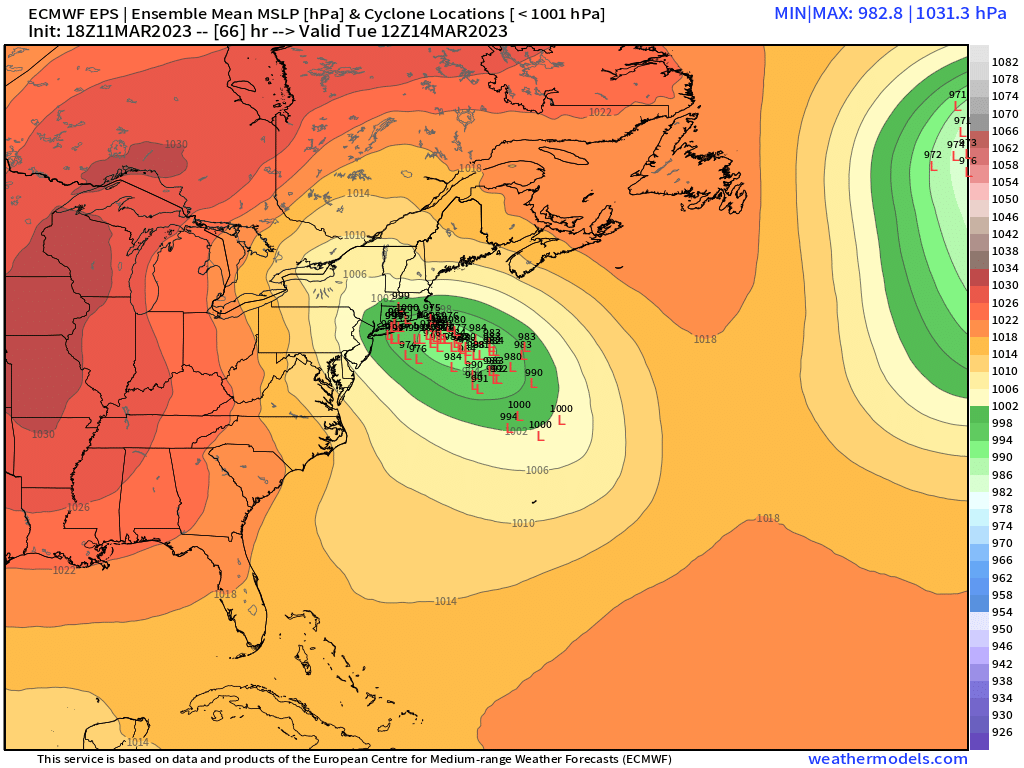
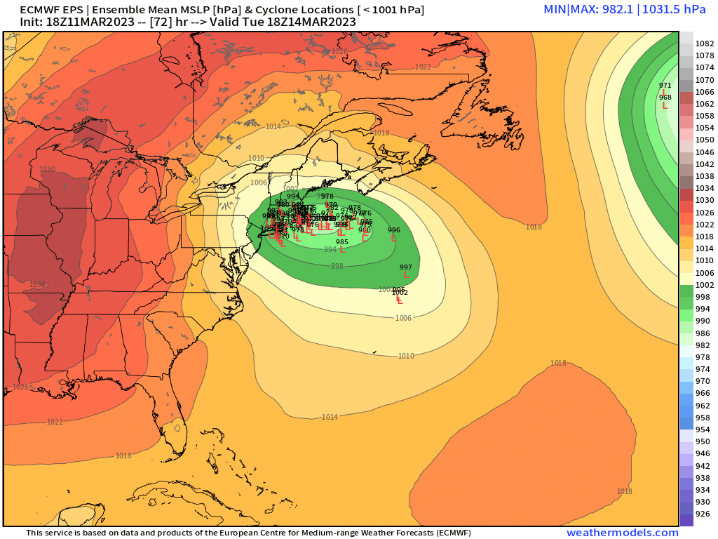
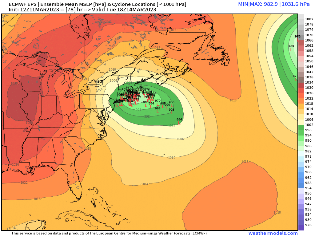
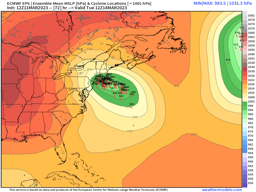
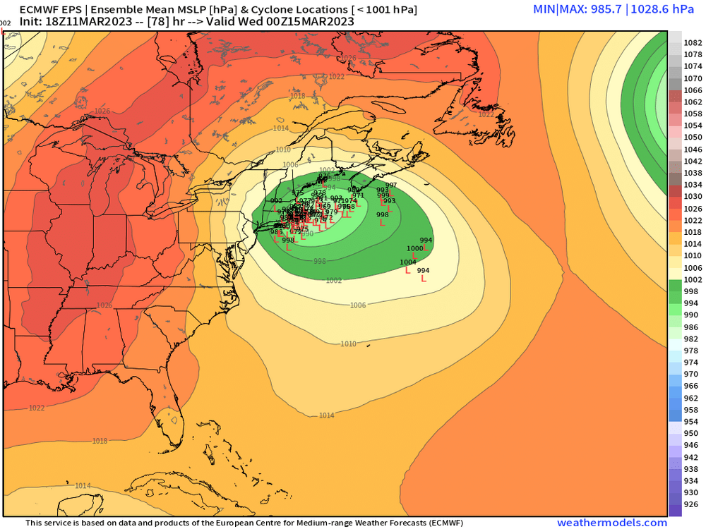
Seeing the ensemble clusters made me feel somewhat better. OP is def on the northwestern 10% of those members. I also like how the trend on the EPS was to rotate it back ESE a bit faster. They really aren’t gaining much latitude north of CHH now. Thats not only good for limiting some of the warming, but it keeps much if area under favorable midlevel dynamics longer. -
The last hurrah? Putting all the eggs in the Tuesday 3/14 basket
ORH_wxman replied to Ginx snewx's topic in New England
At least the OP looks on the western envelope…it’s still a possibility but most of those lows are further east and south at their furthest point NW before rotating back east…I’m hoping that means the OP run will regress back toward that next cycle like we’ve often seen the past couple days whenever we get a westward OP run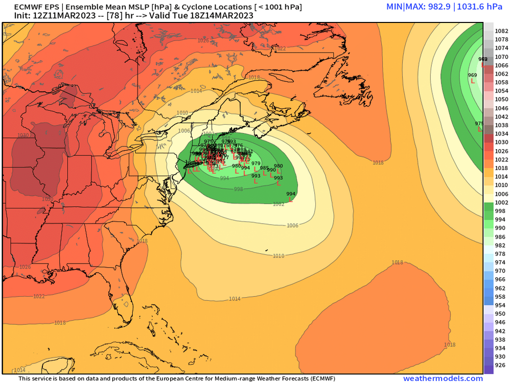

-
The last hurrah? Putting all the eggs in the Tuesday 3/14 basket
ORH_wxman replied to Ginx snewx's topic in New England
Euro doesn’t really sway my thinking that much. The IVT tug is something to keep an eye on, but even those solutions are trying to reconsolidate to the east…my gut says that happens a bit faster given the explosive height falls. Hopefully we keep the southern stream robust enough that we don’t need to worry about lows over ORH anymore like we were seeing on some previous runs. -
The last hurrah? Putting all the eggs in the Tuesday 3/14 basket
ORH_wxman replied to Ginx snewx's topic in New England
It’s a 10 to 1 map too. In reality that’s prob more like 10-15” for us. -
The last hurrah? Putting all the eggs in the Tuesday 3/14 basket
ORH_wxman replied to Ginx snewx's topic in New England
Yeah we need a more wholesale shift east I think for inside of 128 to see mostly snow. They probably get in on some good heavy snow bands on these cape solutions but not before a lot of rain first. -
The last hurrah? Putting all the eggs in the Tuesday 3/14 basket
ORH_wxman replied to Ginx snewx's topic in New England
This is what I was describing yesterday when I said most of us in SNE wanted to see a more dominant southern stream low…it shuts off the WAA going on further west from the northern stream IVT and then focuses all the baroclinicity further east and the low goes nuclear out near the BM up to the cape region instead of having Steve’s dog logs getting burnt by ozone. -
The last hurrah? Putting all the eggs in the Tuesday 3/14 basket
ORH_wxman replied to Ginx snewx's topic in New England
Metro west between 128 and 495 is probably the toughest area to forecast. I’d feel pretty good outside of 495…I think precip will flip to snow relatively quickly there but inside of 495 to 128 is a tough call. I’m not totally buying the dual low idea…it’s prob going to be one or the other…and that makes it hard to forecast because if a low in Westerly RI becomes dominant, then that will cut down on accumulations quite a bit in metrowest (won’t really affect further NW as much)….but if we’re already overlaying a cold conveyor from the east by Pre-dawn Tuesday, then metrowest would easily get annihilated. -
The last hurrah? Putting all the eggs in the Tuesday 3/14 basket
ORH_wxman replied to Ginx snewx's topic in New England
I think your area looks pretty good but not as safe as Litchfield county or ORH county. As long as the low doesn’t sneak up to like GON area, I think you’ll be fine. -
The last hurrah? Putting all the eggs in the Tuesday 3/14 basket
ORH_wxman replied to Ginx snewx's topic in New England
Yeah I kind of include northern Litchfield county in the Berkshires group. But they are gonna get destroyed. Our friend @FXWX right on the county line there at 1150+ feet is looking quite nice. -
The last hurrah? Putting all the eggs in the Tuesday 3/14 basket
ORH_wxman replied to Ginx snewx's topic in New England
I feel like they are the best spot right now in SNE maybe outside of the Berkshires. Almost every variation on these is crushing them. -
The last hurrah? Putting all the eggs in the Tuesday 3/14 basket
ORH_wxman replied to Ginx snewx's topic in New England
It’s gonna be another run or two to figure this out. It seems like the trend has been for guidance to try and do the IVT elongated low but then it eventually decides it wants the southern stream one to take over…I’m hoping we see a little earlier on that consolidation.