ORH_wxman
-
Posts
93,094 -
Joined
-
Last visited
Content Type
Profiles
Blogs
Forums
American Weather
Media Demo
Store
Gallery
Everything posted by ORH_wxman
-
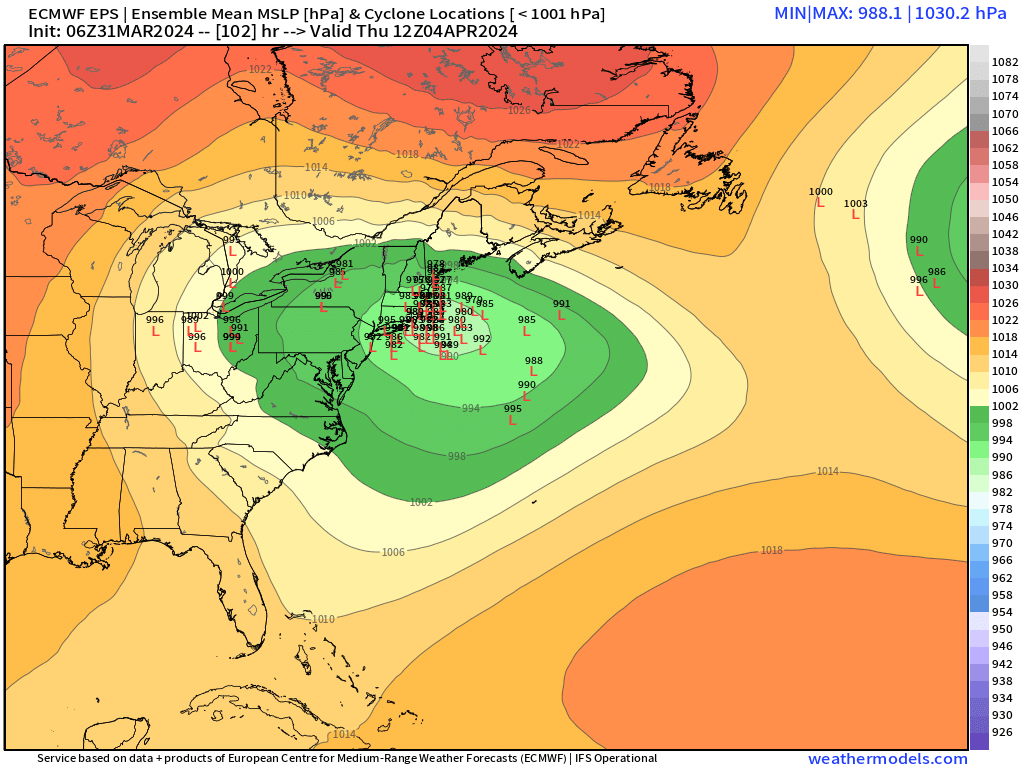
Significant Miller B Nor'easter watch, Apr 3rd-4th
ORH_wxman replied to Typhoon Tip's topic in New England
Destroys Ray with a 20 burger. -
Significant Miller B Nor'easter watch, Apr 3rd-4th
ORH_wxman replied to Typhoon Tip's topic in New England
Oh yeah, I agree. There would def be more excitement if euro came on board but I guarantee almost nobody would be spiking footballs like they would 8-10 years ago if it showed that inside of 84 hours. Despite a little bit of a trend cooler at 12z overall in model guidance, my guess is 90% of SNE posters are expecting almost all rain and that is what the expectation should be. Exceptions are prob from Rays area over to N ORH county and Berkshires…and even those areas are likely a lot of mixed crap too. If we can get a decent move at 00z, then it might get more interesting, but we’re running out of time. -
Significant Miller B Nor'easter watch, Apr 3rd-4th
ORH_wxman replied to Typhoon Tip's topic in New England
I mean, euro has been glue factory material on more than one storm this season. So as long as there are some half-respectable models disagreeing with it, it’s worth watching this threat. But it’s going to be tough regardless once you are south of the pike at low elevation. Even rt 2 crowd could still get skunked mostly if this primary goes too zonked in Michigan/Huron. -
Significant Miller B Nor'easter watch, Apr 3rd-4th
ORH_wxman replied to Typhoon Tip's topic in New England
Not much change on euro. Maybe slightly better with primary as it drifts SE from Lake Michigan instead of east into Lake Huron. But gonna need more help than that though. -
Significant Miller B Nor'easter watch, Apr 3rd-4th
ORH_wxman replied to Typhoon Tip's topic in New England
Yeah both GGEM and Ukie were the flattest in that one. Ukie may have been a touch flatter but both were ugly. -
Significant Miller B Nor'easter watch, Apr 3rd-4th
ORH_wxman replied to Typhoon Tip's topic in New England
Canadian bombs the primary over southern Lake Michigan. SNE will have a shot if that happens. -
Significant Miller B Nor'easter watch, Apr 3rd-4th
ORH_wxman replied to Typhoon Tip's topic in New England
I honestly didn’t read that far back. Was busy with work. But it’s been a theme I’ve noticed since last night’s runs. We already knew a primary into Huron was bad for snow south of NNE but we were kind of hoping it would be over CLE instead previously…but that isn’t happening…however, an alternative version of getting more snow in SNE (or at least down into the SNE/CNE gray area) is to have the primary nuke out much further west over Lake Michigan. -
Significant Miller B Nor'easter watch, Apr 3rd-4th
ORH_wxman replied to Typhoon Tip's topic in New England
Still pretty much a non-event for SNE in the mean though. Too many eastern Michigan/Lake Huron primaries which causes the secondary to rip up through interior SNE. -
Significant Miller B Nor'easter watch, Apr 3rd-4th
ORH_wxman replied to Typhoon Tip's topic in New England
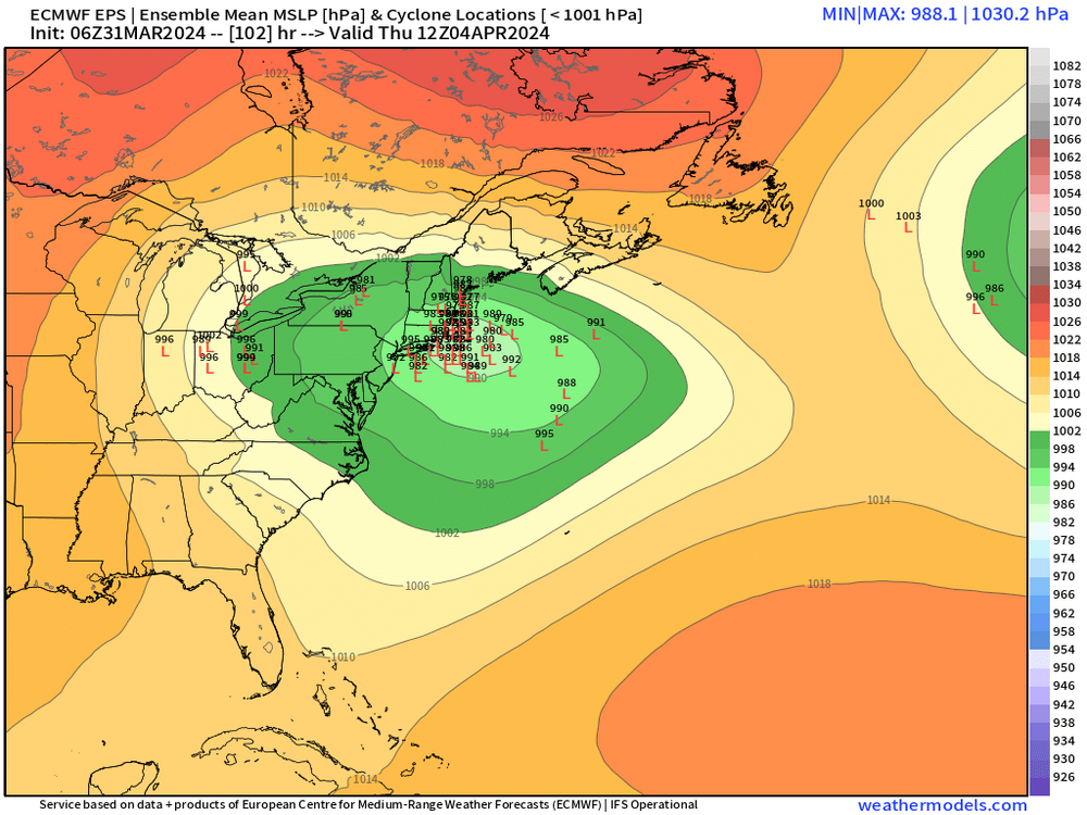
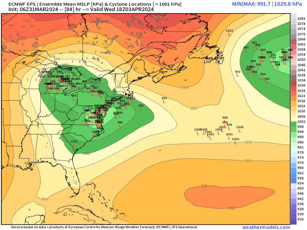
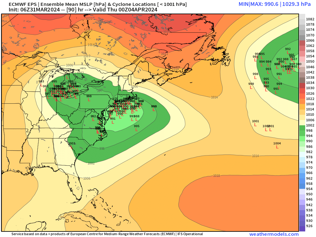
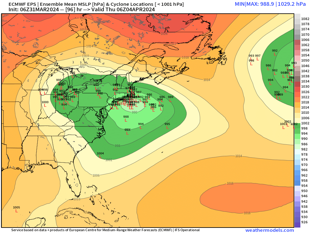
The colder solutions recently have had the primary maxing out over Lake Michigan or far western Michigan instead of the thumb of Michigan or Lake Huron. That is enough to make a difference and allow the coastal to consolidate a bit better without primary interference. Note that the 12z NAM was a “thumb of Michigan/Lake Huron” solution unlike the RGEM/GFS -
Significant Miller B Nor'easter watch, Apr 3rd-4th
ORH_wxman replied to Typhoon Tip's topic in New England
Hopefully the progged convection performs about as well as the 2/13 event. -
Significant Miller B Nor'easter watch, Apr 3rd-4th
ORH_wxman replied to Typhoon Tip's topic in New England
It’s collapsing heights to the east just a bit more…and I think it’s due to the main ULL out west dropping further south initially so it gives a little more time for that PV lobe in Nova Scotia to nudge southwest and try to crash heights just enough as the main ULL out west approaches. If that trend kept up, then it would get interesting for at least northern SNE. But it’s definitely a good development for CNE since it might try to link the WCB and CCB a bit and not allow that WAA to just rip to the northeast and keep everything more disjointed and warmer. -
Significant Miller B Nor'easter watch, Apr 3rd-4th
ORH_wxman replied to Typhoon Tip's topic in New England
ICON was kind of Krafty for E and C MA and SE NH too Thursday AM. Not really biting on that yet but it wasn’t showing that previously until overnight. If you’re hoping for a longshot attempt here, the key is to get that little PV lobe over Nova Scotia to phase into the main ULL early enough to drop heights over New England and crash everything SE a bit before the western ULL wraps up the ML and LL circulation into the interior. -
Significant Miller B Nor'easter watch, Apr 3rd-4th
ORH_wxman replied to Typhoon Tip's topic in New England
06z GFS was a little colder. Actually produces a sleet bomb over interior MA. I’m still expecting mostly rain here but there’s maybe like a 1 in 5 shot it could be a bit more interesting. I’d want to see the 12z runs tick cooler again. 00z was pretty furnaced outside of the Canadian. -
Significant Miller B Nor'easter watch, Apr 3rd-4th
ORH_wxman replied to Typhoon Tip's topic in New England
N ORH county is def still in the game for big snow, but another tick and it’s over there too (outside of maybe advisory type snows on the WAA front end). Really need to stop this trend of a massive bombing primary in N Michigan/Lake Huron. -
Significant Miller B Nor'easter watch, Apr 3rd-4th
ORH_wxman replied to Typhoon Tip's topic in New England
Need to keep the primary weaker and south. But that is the opposite of the current trend. Even for NNE I think keep the upper air a little toned down is what you want…not as much as SNE needs it but there’s a happy medium. But some of these GFS runs are just wrapping this thing up so much that there’s really no chance to consolidate the WAA/CCB together. Hopefully things trend back a little but I’m not optimistic about that. -
Significant Miller B Nor'easter watch, Apr 3rd-4th
ORH_wxman replied to Typhoon Tip's topic in New England
Looks even more like S Canada run. Ottawa to Massena. Even in mid-winter the appetite would be fairly small but in early April after a terrible winter, nobody will stay and track a storm that doesn’t give good snow within 50-75 miles. We are basically one more 00z run bump north from 80-90% of the forum checking out…myself included. -
Significant Miller B Nor'easter watch, Apr 3rd-4th
ORH_wxman replied to Typhoon Tip's topic in New England
I’d hold off up there. Latitude will matter. But yeah, you want a tick south. N of pike crowd between pike and ASH/MHT can still get a big system if this nudges south a little but the trends haven’t been favorable the last 24 hours. -
Significant Miller B Nor'easter watch, Apr 3rd-4th
ORH_wxman replied to Typhoon Tip's topic in New England
It actually trended so far south it looked like all of us were gonna get skunked and then at the last second it bumped back enough to crush CT. We still got screwed up here. We got maybe 4”. -
Significant Miller B Nor'easter watch, Apr 3rd-4th
ORH_wxman replied to Typhoon Tip's topic in New England
Yes. The northward push of the primary is where the issues occur. A system sliding due east from Chicago to Cleveland and redeveloping E of ACY is totally fine. But when the primary rips up into Lake Huron, it’s hard to hold the midlevel structure of the storm in a manner that produces huge snows for SNE. -
Significant Miller B Nor'easter watch, Apr 3rd-4th
ORH_wxman replied to Typhoon Tip's topic in New England
Euro looks a bit warmer and north again. Almost game over for SNE but it does still hit ORH county to Berkshires decent. -
Significant Miller B Nor'easter watch, Apr 3rd-4th
ORH_wxman replied to Typhoon Tip's topic in New England
Yep. Prob gonna check out on this one soon. I’ll give it another couple cycles though since there is still some spread south/colder. But this is starting to get the feeling of an NNE elevation storm and not the more cleanly phased tempest over the benchmark up to ACK. Gonna need a shift south on subsequent cycles. -
Significant Miller B Nor'easter watch, Apr 3rd-4th
ORH_wxman replied to Typhoon Tip's topic in New England
NAM is actually sub-freezing over high terrain of SNE and 925s are between -3 and -4 so you’d get good accumulations that way. But you want to see more global models trend that cold before you consider it realistically. -
Significant Miller B Nor'easter watch, Apr 3rd-4th
ORH_wxman replied to Typhoon Tip's topic in New England
CCB prob wouldn’t get cranking for another few frames as the ULL is still back west. It’s quite cold though so NAM would prob work in a lot of spots even if 10 to 1 is overdone. -
Significant Miller B Nor'easter watch, Apr 3rd-4th
ORH_wxman replied to Typhoon Tip's topic in New England
I think ideally for non-ORH hills/Berks interior SNE (and I’ll loosely define this as 495 belt from Ray right down to near Kevin on 84 NE of HFD) we want to see that primary die a little quicker instead of getting wrapped up into the thumb of Michigan. If you can can keep it more toward CLE instead then it’s balls to wall. -
Significant Miller B Nor'easter watch, Apr 3rd-4th
ORH_wxman replied to Typhoon Tip's topic in New England