

ORH_wxman
-
Posts
90,892 -
Joined
-
Last visited
Content Type
Profiles
Blogs
Forums
American Weather
Media Demo
Store
Gallery
Everything posted by ORH_wxman
-
Looked pretty warm for southern parts of Maine on the CP.
-
06z EPS is pretty coldfor 3/25-26....gets decent snow down into pike region. I personally think the 3/27-28 system looks a little better for trying to get snow, but can't rule out the front-runner. The front-runner will probably be pretty snowy for NNE.
-
Alpine meadows lodge at 6809 feet is at 535” and the 8k plot is at 662”. They are going to crush their seasonal records I think even before the month is over. I think the record at the 8k plot is 707”.
-
The thump from like 1-2pm or so until mid evening was pretty epic. 6-8 hours of crazy. We had about 20” and I’d say the vast majority fell in 6 hours. I think we got a few pellets right near the dryslot but otherwise they were a non-factor.
-
I'd expect Nov temps to be more highly correlated with snowfall in central Maine since November itself (and early December by extension which is going to be highly correlated with Nov temps) is a more meaningful snowfall period than further south.
-
Speak for yourself, I'm all-in on using geese next year to predict the weather a month out.
-
We should be careful in our analysis of "too much data" though.... I agree there's often data overload, but lets not sugarcoat the prior era of forecasting....it absolutely SUCKED compared to now. Even the best mets back then couldn't forecast 5 days out even close to the same accuracy we have now. The computer models that all of us mets rely on just were not good enough and no human can overcome that lack of computing power.
-
Yes, you want multiple signals compounded in the same direction which increase the correlation. Oct has a slight inverse correlation, while Nov has a slight positive correlation, but add them both together and it becomes stronger likelihood. I'll say though that the Oct correlation has weakened in recent years, but it's still there. The biggest conundrum with seasonal forecasting is trying to fit pattern projection onto sensible wx. Nobody who was ever given a composite of December's H5 pattern would predict an above average month on temps and virtually snowless for SNE. The small nuances in that longwave pattern are not predictable at more than a few days lead time so you'll never be able to accurately forecast that type of blocking while also adding the caveat "but it won't produce cold/snowy sensible wx for us".
-
November does have a small correlation to winter temps. But it's certainly not strong enough to use as a primary variable for forecasting winter temps.
-
It can be very good here. Overall though ENSO is a bit overrated in New England. We don’t want super Ninos or super Ninas l, but outside of that, we can do pretty well in any other ENSO state.
-
Lets get a repeat of 3/19/13
-
I think there's a pretty good chance we end up with one more legit threat that gets inside 5 days based on what I'm seeing in the pattern. There's a couple of good windows late this month it looks like. It's too bad we can't get 3/22 to amplify because there's some pretty good confluence ahead of it.
-
Yeah there it is. I remember thinking how crazy that was. Of course that’s why depths got so crazy too that winter.
-
No it was notable specifically because it was Jaffrey’s second 30”+ storm in one season. I remember we were all in awe of a place getting 2 storms like that so close together.
-
I'll add too that Fitzwilliam (and to a lesser extent Jaffrey) aren't ideal for easterly flow events even though they are still good. They are a little less favorable than places like New Ipswich, Temple, Greenville, Ashburnham, Ashby, Princeton, etc....Fitzwilliam and Jaffrey are on the lee side of the Wapack range.
-
I remember jaffrey had 30 or 31” in the PNS but not sure their coop data got recorded. That was one of the last years the coop was even reporting iirc.
-
That area probably had a similar total in the Mar 5-7, 2001 storm...maybe not quite 38" but over 30" and the snow pack there likely reached 55-60" later that same month in 2001 after several more storms.
-
My guess is that 42” will be accepted as legit assuming it came from a coop. It doesn’t look that weird based on the location and other obs around that area and several pics coming out of west Dover definitely support at least 3 foot totals and likely some 40+ in there. It’s not one of those “why are they 30-40% higher than everyone else?” type totals.
-
How did Maine do in the March 5-7, 2001 nor easter? I know they were relatively lower than the monster totals in NH/VT/N MA, but probably not as low as this past storm relative to those areas.
-
Oh for sure...but your elevation gradient out that way is definitely steeper than in ORH county until maybe you get up by Ashby where you can theoretically go from under 500 feet to like 1500 feet in a short distance. So the gradient near ORH was especially eye-striking.It was out of character with the typical elevation gradients we see there in marginal storms and I've experienced a LOT of marginal storms in ORH over the years.
-
Yeah I’m in Holliston where we got about 3.5-4” (literally 200 feet Lower than me half a mile away had maybe an inch or inch and a half). Kind of a bust here where I was thinking closer to 8” prior to the storm. But I honestly can’t complain..this location has overachieved decently in the past 5 winters relative to surroundings. Winter hill area had an insane gradient too…not just the one I was talking about either…but driving down the hill less than one mile to the east maybe had 8-9” of mashed potatoes. So you could theoretically go from 8-9” at 550 feet in N ORH city to 2 feet of snow in Holden in a span of less than 5 miles by way the crow flies. That’s ridiculous.
-
@OceanStWx I wonder if even at same elevation, the additional 1-2 miles of longitude helped with upslope cooling? The parcel is probably still rising 1-2 miles west even if the elevation hasn't increased any further. So a few tenths of extra cooling in that boundary layer made enough difference when the conditions were exceptionally marginal.
-
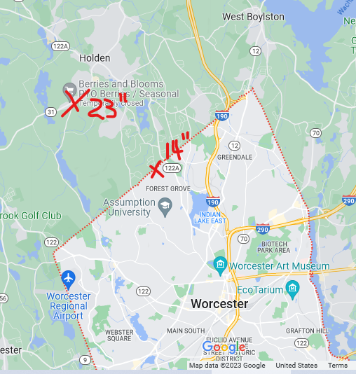
3 NNE Worcester AP 23.0 in 1211 AM 03/15 This is wild based on that PNS (i marked winter hill with the 14")....those two Xs are maybe 3 miles or less by way the crow flies but basically the same elevation:
-
I'm sure it did. Though in the case of winter hill vs Holden, they are on the same exact east-facing slope and similar elevation....so the only factor there was an extra 3-5 miles of latitude made a large difference during that marginal period between 10pm-6am. It was pounding pretty good around 1-2am on winter hill when I went to bed but the snow was REALLY waterlogged....even like a half degree prob made a huge difference in the 900-950 layer. That 925 0C line was like sitting over the city overnight. I noticed the airport actually briefly went to rain about 3 miles south (and 100 feet higher) of Winter Hill overnight...and I don't think we did.
-
In larger events, I've noticed they'll usually not issue a final map until at least 12 hours after it's over. So I'd think by later this afternoon or evening theyll have a final map.


