

ORH_wxman
-
Posts
90,892 -
Joined
-
Last visited
Content Type
Profiles
Blogs
Forums
American Weather
Media Demo
Store
Gallery
Everything posted by ORH_wxman
-
Euro also tries to show a cutter on Saturday after Tday. Clown range but that is different from most guidance.
-
Was 41 at my house when I left. Bottom of the hill was 33 with a heavy frost. Maybe 150 foot difference. Crazy.
-
I don’t think you have to worry about a repeat of last winter there. It was so bad that even a mundane winter will seem great. Even up here it was bad though not quite to the extent that your area (or the coast in SE MA) was.
-
Snow is all that matters most on the forum. Sure, there’s some that like just the cold too…but even for most who like cold, they want snow with it. We can get a torch winter like 2012-13 but you won’t see many here be upset about that winter…and we all know why.
-
Yeah, BOS has gone a decade without a 1" event in November....and even in the days of yore, it wasn't uncommon to do that either (they went between 1955-1967 without a 1" event in November). The irony of the '80s too...between 1985-1989, BOS had at least 3" of snow (including a warning snow event in 1987) in 4 out of those 5 Novembers.
-
I think it’s becoming pretty obvious the Super Nino calls are going to be wrong. How that translates to winter still remains to be seen. The winter could still suck across much of the east. We’ve had low-end moderate El Niños (like 1994-95) that are completely blowtorches. But I don’t see how this Nino goes anything remotely similar to the 1982-83s, 1997-98s, or 2015-16s from a strength perspective.
-
Prob better that it takes a day off....it's been ka-ka recently.
-
What's up with the Euro? Didn't run today?
-
We need a couple more tenths of warming and then have it sustain for 3 months to get a trimonthly reading over 2.0C....that's extremely unlikely at this point. My guess is the peak trimonthly value comes in somewhere around 1.7 or 1.8
-
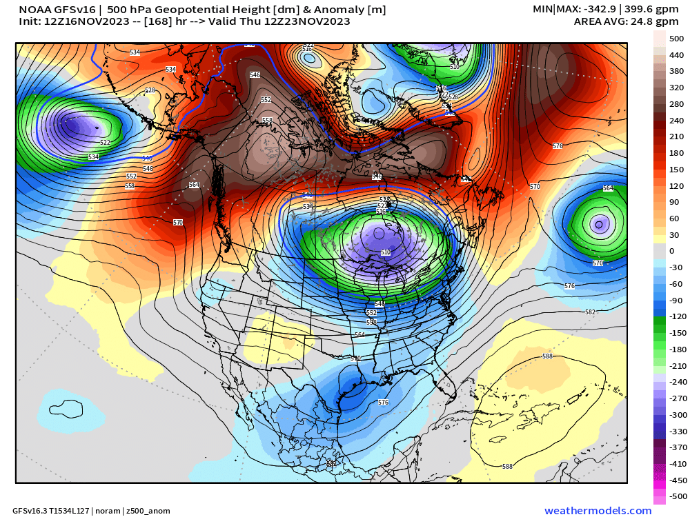
Heh...check out that ridge bridge on GFS for 12z on Tday next week. Might be an opportunity down the line in late Nov with that look.
-
My guess is we end up with the classic worst case sensible wx that often happens in November....we wedge at the sfc but its too warm aloft for a lot of snow....so mostly cold 35-45F rains. GGEM just came in a lot more wedged than 00z at the sfc....so we're probably starting to get some model convergence on cold rain.
-
Even the Euro was pretty much a complete wedge until FROPA.
-
Pretty anomalous cold pattern post-Tday. EPS wants to carry it into early December. GEFS are trying to break it down a little earlier.
-
Only available on 00z runs, but otherwise same link as the regular GEFS. They take a while to update too (00z 11/15 run still not past 384h)
-
ULL that gives us the cold shot on Sunday/Monday/Tuesday stays more stubborn in SE Canada which holds that high tougher….thus produces the snowier solution for next Tues night.
-
Yeah the pattern is there for it...if we can hold the cold into the first week of December, I like our chances even more.
-
Well, for one....GGEM's warmer solution for next Wednesday that I mentioned in the first post seems like it might verify....so that's annoying for the ski areas. That said, it looks pretty brief for the warmth/rain in that. I do think NNE will have a shot or two post-Thanksgiving....that pattern is decent. Even if it's just a lot of rotting LES running into the mountains and getting reinvigorated by upslope. That's still going to be nice. Hopefully we can score one solid QPF snowy system though to lay down a good base.
-
Most of our late November cold patterns are usually dryish anyway....there's a reason we hardly have any big snowfalls (>8") even in late November but they tend to ramp up quickly after the first few days of December historically....my hypothesis is that big cold in November is typically associated with very high geopotential gradients since the south is still pretty warm....so you crunch those early-season PV intrusions into a high height environment down south and it makes it hard to get anything good to amplify. It's easier to get SWFEs and such....but November is pretty early in the season to get good snow from SWFEs here, so it's typically reserved for NNE. Not sure how well that theory holds up with empirical research, but that's my anecdotal observation when we've had very cold November patterns.
-
2021 was near normal. 2018 and 2019 were quite cold though.
-
There’s def been the tendency to see the longer range trend colder as we get closer rather than the other way around in the past few weeks. There’s nothing that guarantees it continues, but all else equal, it’s better than the other way around.
-
Lots of skim ice on ponds this morning driving through Sherborn/Dover in the way to Quincy. First time I noticed that much.
-
Yeah seems like overkill for a 6 week forecast.
-
EPS def out of step with the OP’s milder Tday weekend look. Regardless, still looks quite cold the week after Tday so maybe a chance to sneak in an event there.
-
2012-13 and 2014-15 both had weak starts to the winter with a lot of snow after mid-January. Though Dec 2012 had some interior snow events.
-
That’s kind of how Feb 2013 looked aloft. The northern stream was a bit more receptive, but the overall trough with southern stream vort out ahead looked quite similar. It’s a very good look in mid winter.


