ORH_wxman
-
Posts
90,892 -
Joined
-
Last visited
Content Type
Profiles
Blogs
Forums
American Weather
Media Demo
Store
Gallery
Everything posted by ORH_wxman
-
RGEM not quite as enthusiastic....more limited to N ORH county...esp Rt 2 elevated region.
-
3k NAM was similar too...sometimes it doesn't agree with 12km, but it does on the 12z run. Will be interesting to see if RGEM agrees too...if it does, then that would be a lot of mesos (if we throw in HRRR) agreeing with accumulating snow in that ORH to FIT to 495 corridor.
-
It's there on all guidance....starts off pretty dry in Mid-levels with this polar airmass in place prior to the precip so even though the high is retreating, there may be a few hours of steady snow as evap/dynamical cooling work in tandem to offset the WAA for a time. You want that good burst of precip though....won't be much snow if you don't get a couple hours of good precip rates. NAM has a little cross hair sig in that 495/pike region too, so if that is real, that would help with latent cooling. Good snow growth will latently cool more efficiently than crappy ice crystals falling into a warm layer in the BL.
-
12z NAM coming in a bit colder with that initial burst...shows accumulating snow for much of the pike region near and W of 495....we'll see if that trends at all over the next 12h.
-
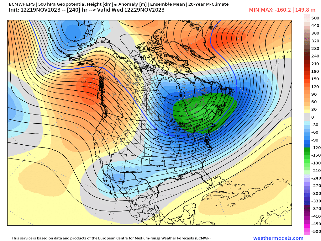
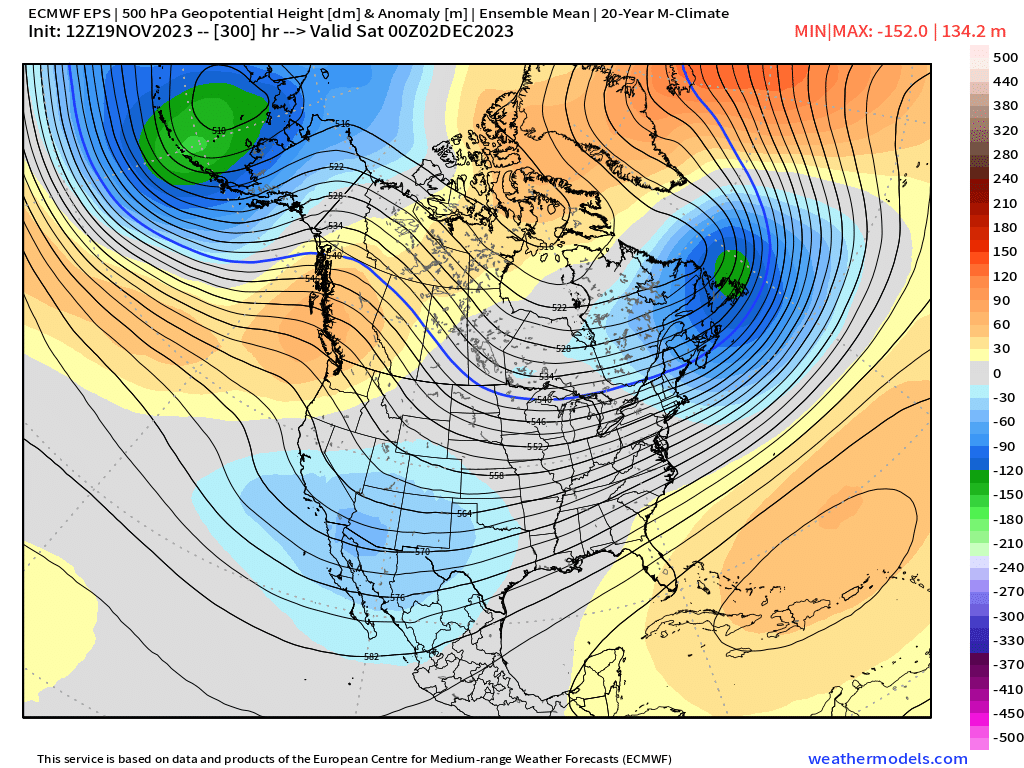
You really want it one on top of the other for it to be classic split flow. The first image sort of has hints of one with those low heights hanging back to the SW but it’s not a classic look. The second image in my original post is closer. But you can see how in the more classic PDII image, because there’s split flow, you aren’t pumping a ridge into the northeast with that trough in the southwest. The ridge up top in western Canada is keeping the heights over the northeast much lower.
-
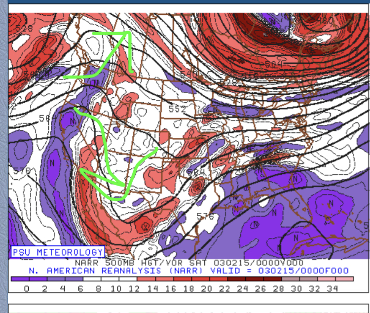
Second picture is more split flow because you have below normal heights underneath above normal heights out west. It’s not a perfect example though. If you want to see classic split flow out west, check out the days preceding PDII storm in Feb 2003
-
Yeah next week is the best it’s looked so far. We’ll see if we can time something. Either way I love seeing that western ridge reloading. We’re fighting the La Niña hangover but El Niño keeps trying to punch back…having a battle of those two might actually benefit us in December… You can see the really cold stuff around D9-10 But then it relaxes a little bit you still have a 50/50 look with southern stream active in the south…if you time this correctly, could have a good event in early December


-
Core of the cold moves east it seems after about D7-8. But this week isn’t exactly warm.
-
18z euro prob has a couple inches in N ORH county too.
-
I remember three stooges reruns on all the time when I was a kid in the late 80s and early 90s. GFS shows multiple chance in clown range. You don’t take any of them seriously but it’s nice to see the potential in the pattern. Should be a pretty good pattern for at least NNE snowfall…even without synoptic snows there’s prob gonna be some upslope and leftover LES stuff up there.
-
Even at 1,000 feet at ORH airport the avg high is 47F tomorrow…43F on 11/30. I feel like we go through this every November. Anyways…given the pattern shown, hopefully we can still sneak something in late month. At least an appetizer.
-
That week after Tday is looking more intriguing. Previously, we had the best cold coming in around Tday and the few days after with a cold (but moderating) pattern to close the month…but it seems the best cold will be that week now which helps increase the chances a little bit for a threat. Its still early for something big but can’t totally hate the EPS or GEFS look…
-
Euro FTW right?
-
The whole progression of the pattern slowed in the last few runs. At first it looked like the max cold was coming for Tday weekend, but now it’s definitely the following week. That actually may work in our favor if we’re trying to get a snow event in November.
-
I mean all you have to do is go back and look at the posts…cold rain was the most likely scenario.
-
Doesn’t matter when you’re talking to a bunch of gaslighters. Might have to actually pull the trigger on bans this winter if blatant lying is going to become a thing.
-
And then it has to sustain for 3 full months without falling to even get minimal Super Nino on ONI…that doesn’t seem realistic. You’d basically have to sustain >2.0C well into February unless you can get a single monthly reading really high (say something like 2.3C or so). I don’t really see a path to how that happens. I’ll never rule it out completely since ENSO is a very humbling thing to predict…but I’d probably want big odds to bet on it.
-

-
It will never not be funny.
-
Ha, now 18z GFS smokes us with a different system Saturday night after Tday. Having a good happy hour today…I guess it is Friday after all.
-
18z GFS…so flat it actually mostly whiffs us south next week. Lol
-
Late November is tough sledding usually…even in our cold patterns. I was posting the other day to OceanStateWx and Scooter about how our Novembers typically are kind of tough because it’s a bit compressed when we have cold patterns and SWFE that early on will favor NNE. So we need to thread the needle in SNE. I wouldn’t rule out a little appetizer though the week after Tday. There’s a lot of cold around…just need to time a shortwave right. Hopefully the modeled December warmup is only like 10 days and we can grab some chances toward the holidays.
-
Where was that article? That sounds awfully analogous to the famous “UK snow is a thing of the past” article back in 2009 and then they got crushed that same winter with anomalous cold/snow. I wonder if the authors of the article are aware that snowfall has drastically increased in Massachusetts over the last half century?
-
Yeah this doesn’t look like a deeply phased western cutter that produces big southerly gales. This is turning into weak sauce regardless of exact track.
-
I keep waiting for it to cave on the trough lifting northeast but it keeps stubbornly holding it much longer than other guidance. My guess is that it is mostly wrong. It will be correct just enough to wedge all of us into a cold rain but wrong enough to keep the snow to a minimum.