ORH_wxman
-
Posts
93,093 -
Joined
-
Last visited
Content Type
Profiles
Blogs
Forums
American Weather
Media Demo
Store
Gallery
Everything posted by ORH_wxman
-
In all honesty, move the whining to the other thread. Catching up this morning was utterly unreadable.
-
Anytime you see BN temps in NYC/NJ and AN in NNE in January, that is not a rain threat here.
-
Yeah it was a little delayed…more like 1/13 on the euro but that looked interesting with the ejecting energy from SW. Ended up being a DC/PHL system this run but wouldn’t take much to make it interesting here. Funny how the euro is burying the energy far more than other guidance….I don’t know the stats these days on it but I wonder if it continues to carry the longtime bias of burying energy in the southwest.
-
It’s been toying with the idea of something larger for a few runs now. I’d want to see some cross-guidance appeal before taking it more seriously.
-
Yeah I wouldn’t bitch at all if we got a 55” winter. Excessively going below climo becomes grating after just a couple seasons. We’ve all endured horrific seasons on here in the past. 2015-16, 2011-12 and 2006-07 (for a lot of SNE. Interior did make a decent comeback)….and for those of us who go back far enough, 2001-02….but we always rebounded with a good winter quickly if not the very next year.
-
Well the very next year we crushed it with a ridiculous NAO block in late December 2010 and first half of January 2011. Granted, we spent most of that time with a -PNA (but not the flavor where we have a perpetual trough down into Baja Ca…more traditional -PNA instead).
-
December 2024 - Best look to an early December pattern in many a year!
ORH_wxman replied to FXWX's topic in New England
Attribution studies outside of empirical temperature/dewpoint increases are easily the weakest link of the climate science. Most of them are low confidence and there’s a relatively high rate of rebuttal papers that come out on those attribution studies. If you take time to read some of them, it becomes clear but the problem is a lot of them get curated in media with big headlines and nobody bothers to look deeper because they assume the headline is not only accurate, but the confidence is high…when often that is not the case at all. The waters get muddied too because if you push back on a specific attribution study or highlight the low confidence aspect of it, you’ll get accused of being a “science denier” which in my opinion, is probably the most anti-science thing you can say. Science is about asking questions and being skeptical of high-impact claims. Saying “ok, let’s see some more robust data on this before confidently making headline claims” is not being anti-science. It’s being pro-science. I have fairly high confidence in most of the datasets being used in climate science. There’s obviously some problems on smaller scales (such as the ASOS temp discussion here) but the larger scale impacts of those should be fairly minimal. The biggest weakness is not the datasets themselves, but the statistical application of that data and some of the climate models being used to analyze that data. You see some p-hacking to squeeze stuff inside the 2-sigma confidence intervals and on top of that, you’ll frequently get “scenarios” in the climate models and only the tail-end scenario makes the headline when it’s somewhere between excessively unlikely and completely unrealistic. -
Having snow in YBY def increases ski traffic but there’s a ton of skiers who go regardless. I learned to ski in the early 1990s when brown grass in SNE was the norm. Even up in NNE it was bad but the mountains usually had enough snow and there were plenty of crowds during awful years like 1990-91 or 1991-92. If you got lots of days that stayed below freezing with no rain, then it was usually solid. As long as it wasn’t like 0F with wind.
-
Which is very rare this time of the year there. Even in recent winters WaWa has been able to keep some natural snow at most times.
-
Most ski mountains are pretty solid if it stays cold.
-
If it’s not gonna snow, it’s a pretty good alternative imho. It’s just beyond boring though from a meteorological aspect. I’m still hopeful one of the multitude of shortwaves rotating down between 1/10-1/15 takes hold. Would be nice to at least get a moderate event.
-
Yeah prob a lot of -6 to -8 type days. Average highs in SNE are in the low to mid 30s and a lot of days are going to be in the 20s for highs. Not arctic cold but somewhat BN. That’s probably ideal though if you aren’t going to snow…it freezes all the ponds and keeps skiing in solid shape for the winter sports people while also not utterly destroying our heating bills and making it overwhelmingly uncomfortable outside.
-
These last few winters have given us a good taste of what being a severe weenie in New England is like.
-
Man, it’s been bad but we've reached the nadir when we’re basically giving up on January 3rd. I guess we can always give up on Thanksgiving next year.
-
I mean, what’s the alternative, 44F rainstorms with an AK vortex? I’ll keep rolling the dice with a good look and hope the nuances don’t screw us over…in the long run, you’ll do well betting on those looks.
-
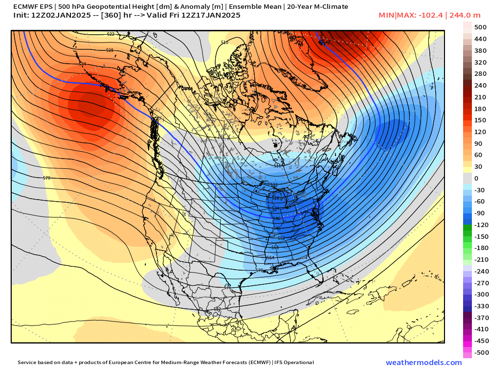
Look at the NAO region right back into Hudson Bay on the OP run versus the ensemble mean.
-
I think there is always undertones of CC baked in anywhere, but the question is whether it explains 60% of the issue or 1% of the issue. I lean toward the latter in this specific case. There's so many other variables (including other parts of the atmospheric circulation that CC influences) that can offset a single variable....a very simplistic example would be "more precip in the winter is offsetting warmer temps which is why we saw an increase in snowfall from the 1970s-2010s". There's probably a large influence of natural variability there as well, but we do know that increased precip and increased temps are an undertone to CC and both of those occurred...however, when it came to snowfall, one of those was offsetting the other.
-
Yeah it's true in a vacuum....the idealized model so-to-speak. You are preaching to the choir on the physics of this. But clearly there is something offsetting the isolated variable of westerlies/polar jet because our cold season precipitation is not even holding neutral. That's why I'm skeptical of "oh the reason we can't get a storm to amplify right now is because climate change has screwed the orientation of the jet stream so now we're stuck with a disproportionate number of positively tilted troughs versus the 1981-2010 baseline." If that were true, we'd see a drastic decrease in cold season precipitation, but we haven't. It's hard to ever prove anything in the case of a few events or even a few seasons....but my hunch is the reason we're failing in the shorter term here is that the block is verifying stronger and further west than originally progged which is turning the flow extremely meridional to our west next week while simultaneously not allowing any real downstream ridging....so it is going to leave us with a positively tilted longwave trough.
-
Poleward shift but also weaker trend as well....i dunno, doesn't seem very convincing in explaining our current predicament. But my default is always to be skeptical of attribution of any given setup to a larger trend. It would seem to only explain a general warming trend and the the result of deceasing delta-T between polar region and mid-latitudes (hence the weakening of the jets when arctic warms faster than mid-latitude). Of course, I'm sure we'll have no problem getting negatively tilted troughs when we are lacking good confluence in Quebec.
-
Do we know for a fact that we are getting more positively tilted troughs than usual in recent years? That would normally have a consequence of much drier sensible wx than normal, but that doesn't seem to fit the observed data.
-
December 2024 - Best look to an early December pattern in many a year!
ORH_wxman replied to FXWX's topic in New England
CC monitoring on a global or even national scale won't be affected by a few bad data points....there's so many of them that it amounts to a rounding error. But it will certainly affect the local climo records. When you have a 5 year period that is consistently calibrated 1-2F too warm, that would definitely be a problem. It will also affect model verification stats and could be an increasing problem for models that learn from observed data. If the models are accurate for their temps, but they "think" they are running 1-2F too cold versus reality when they actually aren't, that would be an issue too. -
Yeah maybe it doesn't work out....but then again, this current pattern is still only in its infancy. Something in the 1/10-1/15 range could easily pop. We had zero problems getting negatively tilted troughs on New Year's day.....
-
Gladly take a roll of the dice with this pattern at end of EPS.....slightly neg PNA with AK ridging and an east-based -NAO....at least suppression would be less of a worry.
-
New England Winter 2024-25 Bantering, Whining, and Sobbing Thread
ORH_wxman replied to klw's topic in New England
Yeah PSM is the same, but they should prob be a touch warmer than DAW....and DAW being 3-4F warmer than SFM seems a bit suspect. At least its not like 3-4F warmer than PSM now, lol. -
New England Winter 2024-25 Bantering, Whining, and Sobbing Thread
ORH_wxman replied to klw's topic in New England
Looks like it’s better…now ORH/BDL OTOH….