ORH_wxman
-
Posts
90,892 -
Joined
-
Last visited
Content Type
Profiles
Blogs
Forums
American Weather
Media Demo
Store
Gallery
Everything posted by ORH_wxman
-
Yeah I feel like you could extend it from 1992-2015. While 2018 and 2021 were good, those were clearly in a different paradigm where the crazy exciting stuff was becoming far less frequent. I mean, even in the 1980s we had the occasional bomb…they were just far outweighed by the torturous regimes of all shapes and sizes. For some, it’s 1993-2015…Scooter and the CT Valley would beg to differ about December 1992 being euphoric.
-
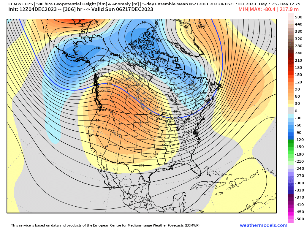
@CoastalWx Todays weeklies show that bit of increased split flow we were talking about earlier for week 2…hopefully this trend keeps up and maybe we can avoid a pre-Xmas grinch
-
The weeklies sort of showed that happening when you break it down into the sub-week level. Between roughly the 20th and 25th it really tries to spike the PNA via Aleutian low intensification even if the absolute strength of the low isn’t super high yet. The fact that it tries to replace Aleutian ridging is enough.
-
EPS has that window of opportunity similar to what the GFS showed…more defined on todays 12z run.
-
You need to fire up a blog post for the southerly wind threat.
-
2016-17 was a pretty solid winter up there too not long before he moved there…had a couple of latitude storms. It’s like as soon as he moved there l, they turned into the CT river valley.
-
Then followed by an ‘07-08 extreme latitude gradient winter where he gets almost double the pike region.
-
Ensembles haven’t been as enthusiastic but they’ve been VERY uncertain. If you look at some of the spread, it’s higher than climo baseline for D13-16. It also goes back to what I mentioned earlier in how 4-5 days ago, the end of the ensemble runs were for the 12/15 period and they looked a lot like they do now for 12/20…but as we got closer, they kept cooling that 12/13-17 period. It remains to be seen if the same will happen for that 12/20-22 period, but if MJO goes into weak phase 8, then you’d actually have another factor that could help it trend more wintry.
-
There’s a window in that period as Scott and I were discussing. Some decent cold around and Canada gets a little bit blocky so that can work. Would be nice to get a good break early this winter after last year’s constant bad breaks. Good to see a Scooter high to the north…even if it’s clown range.
-
You do have to lower that DGZ region when we’re talking about the south shore and slight onshore flow in the 850-900 layer. Salt nuclei bring the DGZ down into that -8C region.
-
One thing I’ve noticed as we get closer to verification is guidance has been showing more split flow out west once it gets inside of D10-11 which is one of the reasons that mid-Dec period has cooled a bit in recent runs. Guidance initially shows a phased deep trough out west but then it turns into a SW trough but a ridge over top of it as we get closer. The base of the trough breaks off. We’ll see if it sticks. If that happens again as we approach that 12/18-12/21 period, then maybe we can stay in the game even if it’s not a very cold pattern or ideal look further upstream in the PAC.
-
I was mostly talking about December....but even that said, what happens to that composite when you get rid of Super-charged ENSOs with monster GOA lows? That's kind of my point in this. Composites are nice, but when you start filtering for El Ninos, you can get some skew from one or two years because you're reducing sample size. Jan 2003 and the period around the Jan 2005 blizzard were phase 8 in El Ninos....total opposite of the 1998 example. Go check late January 2015 too. I was going back checking phase 8 in December in El Nino and it's pretty uncommon (no surprise as Dec El Ninos tend to have those phase 4-7 a bit more common), but the last 3 occurrences are early Dec 2018 (cold pattern but missed out on snow), week 3 in Dec 2009 (HECS for Mid-Atlantic on 12/19-20), and early Dec 2002 (another snow event for the northeast). If you go back further, I'm sure you'll find some warm ones since you never bat 1.000 in meteorology.
-
Phase 8 and +GLAAM is typically associated with -EPO/+PNA out west....I agree it's not a warm pattern. There can be exceptions if you get a monster GOA low like 1997-1998 but I am not expecting that in this El Nino.
-
Their high end amount is the same as the actual forecast....kind of weird. I'd expect like the 90th percentile to be around 3" or so.
-
3k had borderline advisory for area near MQE....gonna have to watch that. I'll actually be in Quincy tomorrow for work and I drive through Milton to get there.
-
He’s 5-posted so he can’t really get into responding to much. Blending is usually the way to go at this time frame…obviously we’ll know more on which one is “more correct” as we get closer.
-
Prob more a few days later than that.
-
Yeah that was the Dec 6th system we were originally hoping had enough room to amplify into a real storm....it's a very good shortwave which is why we still may see some snow despite it not getting the room it needs to amplify downstream ridging. We would've had a good enough airmass in place too.
-
I'm expecting a blog post from Ray by tomorrow morning on the event. He can title it "A Cranberry Bog Festivus".

-
I should have mentioned the immediate coast in places like PYM county might be rain issues because of the CF, but most of the land area is west of the CF, so it would be plenty cold to the west of that for snow. If we can punch some decent localized lift, the soundings are pretty decent, so someone could see a little surprise.
-
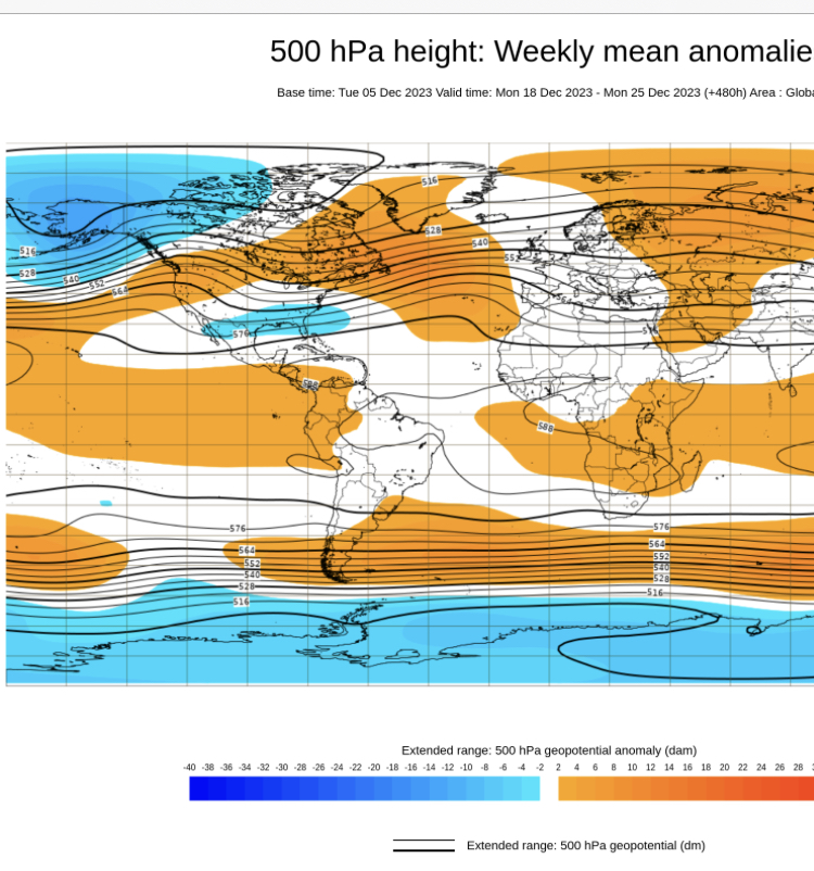
Those are the weeklies and that is the last week of the month, not week 2. Here's what the EPS shows for that Dec 13-17 period. You can see it's not all that bad. +EPO so it's not an arctic airmass type pattern, but enough wetsern ridging to give us chances if it came to fruition...as I said to Scott just a minute ago, GEFS is more hostile

-
EPS far more "favorable" (still pretty meh) in that period than GEFS. Kind of funny because about a week ago, the GEFS were more weenie-ish and the EPS was kind of meh for that period....now GEFS is a torch while EPS is still basically showing "meh"....would be nice to sneak something in there.
-
Wednesday morning for eastern areas could be first measurable for them....worth watching. We're saturated up to about the -12C layer with low level lift and of course we know along the coast, the salty air produces excellent snow growth down into the -8C or even warmer layer. The low levels are cold too so no rain issues....only factor will be if we can get a few hours of steady snow or if it;s just a few scattered snow showers that can't sustain.
-
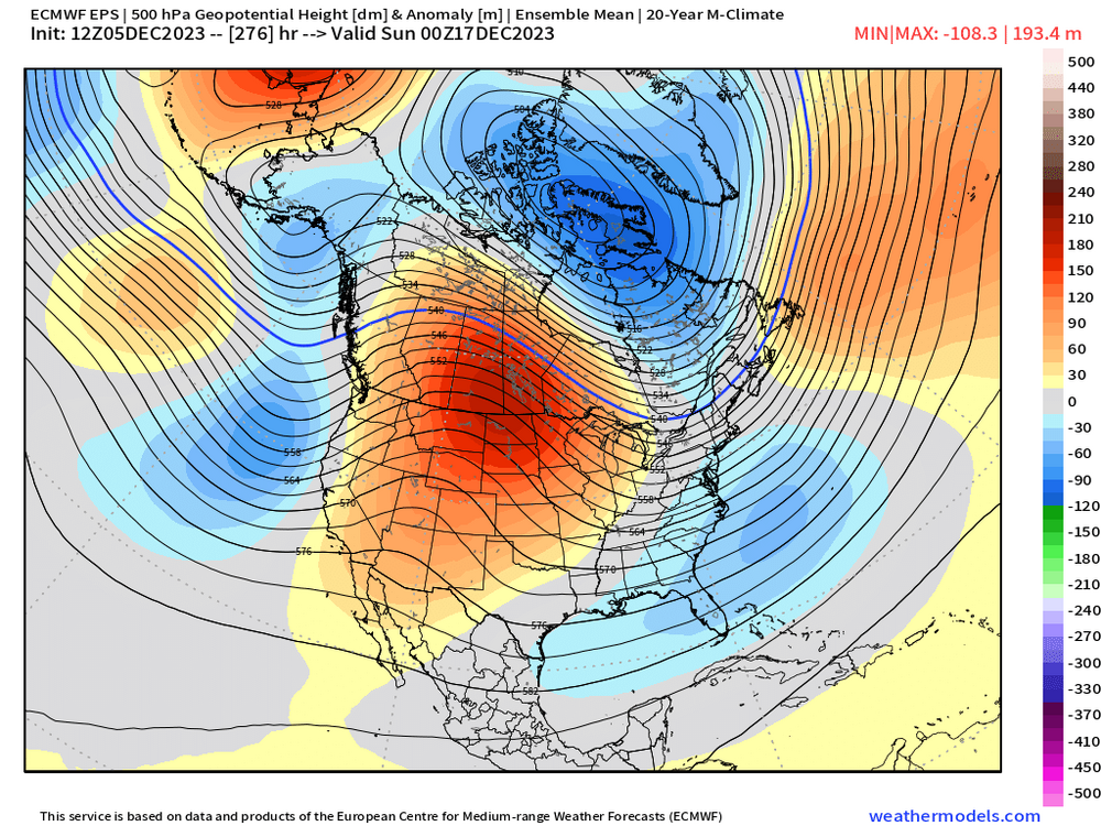
Decent uncertainy in the Dec 14-20 timerange too....it's not a cold look, but it doesn't look like a furnace at the moment either. Some ensemble memebrs are torchy but others are actually near normal or slightly BN with a few snow chances. That period might define how many view the month overall....if we "Steal" a snow event in that week prior to the better pattern setting in, then the month would be viewed a lot better than waiting until later and hoping to get something....esp if the big snow events don't happen until January even if the pattenr becomes favorable in late Dec.