

ORH_wxman
-
Posts
90,892 -
Joined
-
Last visited
Content Type
Profiles
Blogs
Forums
American Weather
Media Demo
Store
Gallery
Everything posted by ORH_wxman
-
Most of the CC doomsdayers when it comes to winter don’t have a very good knowledge of historical variability. You mentioned the 1930s-1950s and that was actually a pretty brutal period too in New England for snow lovers…the early 1950s were actually unmatched for a LONG time in terms of warmth and low snow...esp in NNE. It doesn’t require rejecting CC to understand that natural variability works on top of it. We’ve had these discussion in here before many times but you can only lead the horse to water…. I think I posted some maps on how the northern plains/N Rockies were the fastest warming region in winter for a few decades in the late 20th century…now those areas have actually had an negative trend (cooling) since the 1990s in winter while the northeast and SE Canada have had the strongest warming trend during that time. Temporal and spacial difference are going to happen and it wouldn’t be surprising to see another period of colder/snowier winters in the NE after this recent period of warmer/less snowy winters. Maybe this year will help turn the tables since El Niño can help shake up the Pacific pattern.
-
If we got a 14-15 repeat, it would be impossible to not call it a great winter if you like cold/snow. Or a 57-58. Both were near shutouts in December around here.
-
We’re paying for that string of awesome Decembers…though honestly, Dec 2019 and 2020 were pretty damned snowy and active but they both got tainted by a nasty cutter or two…including a top 3 worst one in2020.
-
There’s a reason patience was always considered a virtue…lol. I think most of us have been pretty fair about when to get worried and when not to. It’s a bummer that we didn’t sneak an event in during mid-December but I think we have been pretty consistent in saying if we get to late month and it doesn’t look better, then we can get worried…but that hasn’t happened…if it changes for the worst and it looks like we’re gonna punt a l out of January, then I’ll get worried.
-
I actually love the ensemble runs last night. Got that retrograding GOA low going toward Aleutians. I think we’re setting up a really nice pattern for early January…we’ll see if we can sneak something in the week after Xmas to close out the month, but I’m not gonna take any toaster baths if that period doesn’t work out….the late month stuff is prob going to favor in and up too with the airmasses still not arctic.
-
I’m prob getting there pretty early (between 4-5) since I’ll go straight from work and I’ll be either in Quincy or Boston that day.
-
No, Jan 87 was good. Very active.
-
Starting to look a lot like Jan '87 over North America....
-
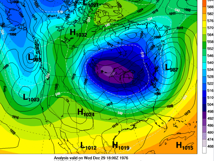
@Typhoon Tip 12/29/76 was an absolute whopper for the 128 belt down into N RI. It wasn't a super phased monster blizzard, but it produced a lot of 12-20" amounts in that corridor. That is the storm Ray loves because ORH was too far west and only got 4".
-
Euro still showing that weak signal around 12/23 too....verbatim it runs into a block and gets shoved SW....it's not a big system, but could be the last chance to whiten the ground before Xmas. 26 years ago was a pretty weak-ass looking system too.....lol.
-
Yeah that was a fun look. Big slow mover too. But I think we’ll start getting some good chances late month and esp into January.
-
12/22-23 was a big rainer for all of New England.
-
I wouldn’t totally sleep on 12/23-25 yet if Canada wants to get blocky. Those can go either way…you can end up under a ridge and be 50F and partly cloudy, or you could end up with snow and 27 if there’s a block over Hudson Bay and shortwaves are diving under you. It’s not something I’d bank on, but it’s plausible.
-
I’d take the Euro and run. That would prob be a few inches anyway.
-
Ukie is interesting too but it has the ULL a little bit west of optimal so the snow is mostly in far western SNE into SE NY. But at this range, we’re mostly just interested in the trend of a trailing ULL being strong enough to spark cyclogensis to our south…we’ve seen it on the GEM and Ukie….GFS is not biting but I have a feeling the Euro might considering the EPS look at 06z.
-
GEM looks interesting. Like some of the EPS members on the trailing ULL. GFS is ridiculous in that it does that retrograde job and produces a bunch of snow/sleet/ice over the region in a long duration event next weekend. Selling that clown look.
-
No that was the 12/29/76 storm....the 1981 storm was decent in ORH...I think they had close to a foot. But it was definitely better in the 128 belt where some 18+ amounts happened.
-
Yeah we’ll have to watch the ULL…nothing last night was great verbatim but it was very close on a few different solutions. Might be able to sneak a few inches if it broke right…low probability but plausible.
-
Yes the bulk of the 1981 storm was Saturday 12/5 to Sunday 12/6. Good memory.
-
Almost looks like the 12/5-6/81 storm that backed it from the east.
-
I think the 12/19 storm is likely warm. The week after that looks more interesting though than it did.
-
‘94-95 prob would’ve been much better if it weren’t for a bad polar domain.
-
I wish we could trust the weeklies more…they look amazing for January. But really the confidence drops so much after D10-12 even on the regular ensembles…nevermind weeklies. If there’s one takeaway from the last couple of runs starting last night, it’s that even if the central Canada blocky pattern doesn’t produce, it’s a good omen for the polar domain later on…we should avoid a ‘94-95 evolution even if we temporarily look like 1994 for a week in December.
-
They are pretty horrible after week 2 which is how far out the ensembles go anyway. They really don’t provide a ton of value.
-
Ensemble member 6 was run out of Ray’s basement. Gets warning snows on the backside of next week and then another system hits just before Xmas for the double whammy.


