

ORH_wxman
-
Posts
90,892 -
Joined
-
Last visited
Content Type
Profiles
Blogs
Forums
American Weather
Media Demo
Store
Gallery
Everything posted by ORH_wxman
-
What’s up with the MJO? Everytime I look it’s going like 10x faster than guidance thought it would. Now into phase 3 by new years.
-
You completely missed the point. Anecdotes don’t mean crap (see the Minneapolis example from above…warmest winter in record there is like 135 years ago). Yes, we’re warmer on average than decades ago but this would’ve been a shit pattern regardless of CC. Maybe we would’ve been +3 instead of +5 if it was several decades ago. Michsnowfreak was pointing how funny that random article talking about a warm Christmas in Minneapolis as if that’s the new normal…no, it’s not the “new normal”. The warm records are easier to break because of CC but an excessively warm December pattern in an El Niño doesn’t represent a new normal. These discussions are pretty dumb in a seasonal thread as it is…take it to the CC forum if you want to argue that 50s in the northern plains is a modern day normal.
-
It very well could be. 1990 was really bad though. That’s the only one off the top of my head that might compete. Maybe 1998 too. I’d have to check to see if some garbage year in the early ‘50s might have matched/exceeded it. 1989 was about as bad as it gets for snow but it had the obscene record cold in December and the moderate Tday snow event so that automatically puts it above 2023.
-
To be fair, most of those images are weeklies. We know not to trust those…esp past week 2. I do remember that fleeting time in late November (shown in the first image) when some guidance tried to make the second week of December much colder/stormier. That’s fair game, but it did flip back to showing meh pretty quick. The NAO verified but it didn’t have any staying power…so we only got a few days of BN temps, and the shouts shore did get that one snow event during that time.
-
Yes it is a decent pattern on average for New England. Also seen at times in the 2008-09 winter to name another. I think the excessive warmth last winter and so far this winter has made many forget that we don’t need the PV on top of us to have decent snow chances. But it will probably take a few events actually verifying for many to realize it.
-
The empirical data speaks for itself. I don’t think anyone in this thread believes CC isn’t happening. But on a science-based forum, you’d expect a bit more rigor on the subject. Anecdotes are fun for clickbait but they aren’t climate science. If people want some more fun warm Minneapolis anecdotes, I suggest they Google “winter of 1877-78 Minneapolis”
-
20% of daily allotment on a 384 hour OP prog.
-
It’s become embarrassing at this point…some of the responses when you point out a hyperbolic article.
-
Think it would rank 3rd or 4th warmest on record. In reality it’s prob closer to 8th since the ASOS is about 1.5-2F biased warm since 2020.
-
There’s no doubt that the first half of January will be drastically different than December. December had no cold on almost the entire continent. Canada is going to get some real cold with that -EPO and that is going to dump into the CONUS too. How much our little corner of the CONUS benefits from it remains to be seen, but it will certainly be a much different longwave pattern.
-
BOS +4.3 MQE +4.5 ORH +6.7* BDL +5.3 PVD +3.4* *denotes bad/unreliable temp data
-
Yeah if I was the GM I’d be saying come ski for 20-30 bucks and maybe you make a killing on concessions/lunch in the lodge. Try to get some volume-based profit. Anyways, we have a couple interesting patterns coming up…we get a more split-flow Nino look for the first week of January but the ensembles are giving way to a La Niña look week 2 in January with a -PNA…but you also have a -EPO and a -NAO. That pattern could be very good for us or we end up dealing with cutters. Regardless, total change from December…Canada is likely to get very cold in that pattern.
-
Nobody is skiing there except season pass holders or maybe the few unlucky families that booked that week in advance.
-
It was. PDI whiffed basically all of SNE save maybe 1-3” on the south coast. 2016 got double digits into southern SNE.
-
Certainly on that track it would be.
-
EPS are a little more bullish on 1/7 than 1/5…the 1/5 wave a weaker and more seaward but still has some decent members. The 1/7 wave seems to have a lot more members and the mean is closer to the BM.
-
Yeah that’s been a popular period on the ensembles. Lower probability for something around 1/2. But that one has trended more sheared the last few cycles.
-
They looked fine to me. But we’re only supposed to ignore clown range these days unless it shows a torch, then we believe it.
-
Oh yeah I remember you posting here in some of the greats. Didn’t realize you moved to FL. Gonna have to do a weenie storm chase when you get a chance.
-
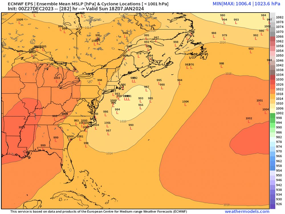
This 18z euro panel shows just how close of a miss the weekend system is to being something way better. If that northern stream shortwave comes in just a little further west (maybe 100 mi if that), then you get a phase a probably a nice interior Nuke…but instead it’s a close miss.
-
Saturday is the day for snow chances. Too warm prior to that. Best chance in CNE and NNE but can’t rule out interior SNE yet.
-
Yeah quite active. It’s not very cold for NE (in fact we may average AN the first week) but it’s still cold enough for snow threats. Bulk of the cold is out in the plains after the first few days of the month.
-
No, though both were still bad at ORH (69.6” combined)…but they can’t compete with 1953-54 and 1954-55 which had a pathetic 52.4” combined.
-
Def doable but quite unlikely. Esp in an El Niño where an SSW is almost certainly going to occur in early January.
-
1979-80 to 1980-81 were the worst back to back winters on record for BOS in terms of snowfall….34.8” total combined for the two. In order to beat that, they’d need 22.3” or less this winter.


