ORH_wxman
-
Posts
90,892 -
Joined
-
Last visited
Content Type
Profiles
Blogs
Forums
American Weather
Media Demo
Store
Gallery
Everything posted by ORH_wxman
-
No it isn’t. It’s cold enough to snow down to Mid-Atlantic.
-
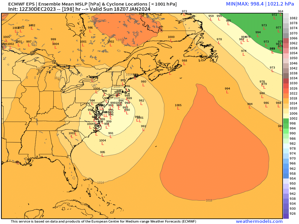
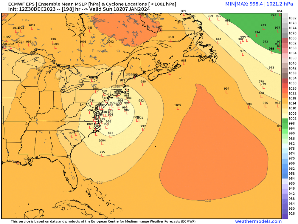
I actually agree that 1/7 is still a longshot but I won’t confidently dismiss as easily as you because it’s not a prerequisite to have a ridge out west to get those to gain latitude. You’d just want to see that southern stream a little deeper…incorporate a bit more N stream energy before it tries to turn the corner. We’ve seen several big southern stream storms in the past with a trough out west.
-
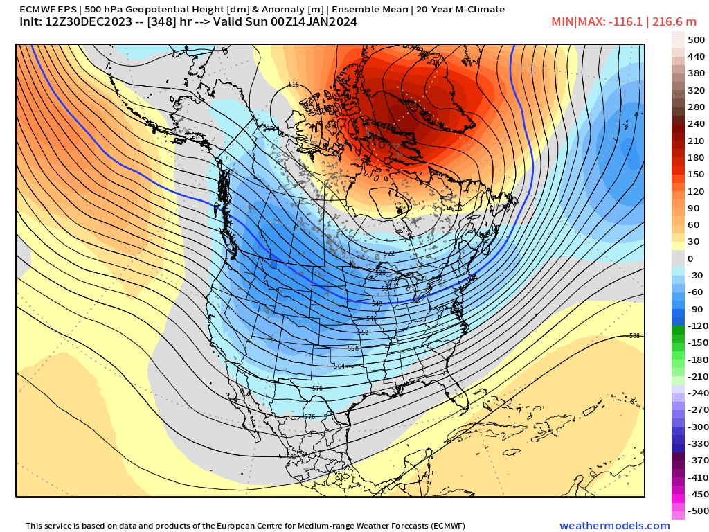
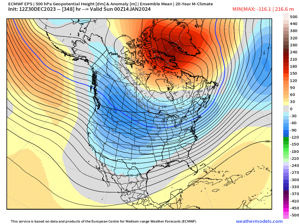
EPS is really trying to build the -NAO mid-month. Like retrograde that North Atlantic ridge back into Greenland and Baffin/Davis Strait. That would keep things interesting despite a meh N PAC
-
Surprised to see this
-
You need a bit more northern stream insert on the Euro for 1/7 or you need confluence to lift out a little faster. Plenty of time on that one, but that’s what you’ll want to look for in the coming days.
-
Especially when that blocking is starting to CAD the 1-10 system. That one might not have rain for at least NNE.
-
GFS suite is producing more northern stream light snow than before. Southern stream doesn’t really phase in well like on GGEM or ICON…but that deeper northern stream does give us a “consolation prize”.
-
It’s extremely hard to put a percentage of attribution on a thing like snowfall over a short 5 year period. Snowfall is one of the highest variance weather outcomes we have. Some of the warmth is definitely connected to CC but not all of it.
-
Yeah honestly not bad for 8+ days out. That’s a very intriguing setup with plenty of cold too.
-
GFS not really biting on 1/5 for a big solution. Does have a general light snow over much of New England though. Maybe 1-2” for many.
-
More snow on the season for Scooter than Mitch?
-
The old saying is it’s darkest before light. Just keep giving us chances…we got 1/5 and 1/7-8…hopefully at least one of them works. Then who knows…maybe we can flip the script and turn 1/10 into an overrunning threat. Not having chances is probably a lot worse…ala 2020 or even for long stretches last year (though honestly, last year we had a decent number of chances that just failed in a variety of different ways).
-
Kind of weird that the 00z Euro suite basically got rid of the 1/5 storm while other guidance all has it. The 06z EPS did bring it back a decent amount just looking now. Not sure what was up with the 00z run. The 00z EPS did have a number of decent hits for 1/7-8 again despite OP being south and wide right. Something to watch still…esp for southern peeps.
-
Pattern change starts with the 15th cutter….complete by the 25th.
-
And even pre-TWC (we didn’t get cable until late ‘93 though my grandparents had it a couple years earlier) You would just wait until the local news came on and when you saw the snow symbols on the map you immediately perked up
-
Needed another all-day 40s on New Year’s Eve to have a chance but it looks like NYE is going to be sort of chilly for recent standards. Highs around 34-36 with lows a bit below freezing. Tomorrow morning’s low looks like it will get counterfeited too prior to midnight tomorrow night.
-
1/5 got weaker on guidance yesterday but it has come back much stronger today. 1/7-8 has been pretty weak on OP runs today (though 12z GFS tried to clip us) but stronger on the ensembles. Both are still a ways out. We’re talking 6+ days away for 1/5 and 9 days for the following system.
-
Mark Rosenthal used to sometimes use “tempest” and we all remember him saying “snowing to beat the band”…he loved that expression.
-
EPS was more interested in 1/7 than 1/5 today which was kind of surprising to me based on OP run. Def didn’t agree with the OP on which one was more likely. There are quite a few solid hits for 1/7 on the EPS. The LR did look better too beyond that as you mentioned. Hopefully the cutter turns more into a CAD system.
-
You’d think but we haven’t gotten many breaks in the past 4-6 winter months going back to Feb 2022…I guess for your area it’s longer since you kind of got skunked by the Jan 2022 blizzard. We’ll see on these two systems.
-
Yeah many of those “non-major teleconnector” storms have late trends. Hopefully we can squeeze on of these into an ideal track.
-
That one is def worth watching. Close call…get a little more neg tilt on that sucker and it would be a pretty big storm for eastern areas. Still watching 1/7 too but that one needs a bit more work. Would help if we had a northern stream shortwave trying to dive into it as it hits the east coast to turn it north.
-
Most of them are significantly colder. Look at January and esp February temp anomalies in El Niño…a lot of those comeback years had like -6 departures in February. Years like 2007 and 1958…of course 2015 is the extreme example when Feb 2015 became the coldest month on record for a number of places round here.
-
Yeah both are still too far out to be using OP runs more than just eye candy (or lack there of) But they seem to be coming back a little stronger as signals on the 12z suite so far. There is a nice cluster of further west members on GEFS at 12z
-
GFS trying to give more room for 1/7-8. Still has 1/5 but it’s a bit SE. GGEM is more amped for 1/5 but it’s an interior special. Wide right for 1/7.