ORH_wxman
-
Posts
90,892 -
Joined
-
Last visited
Content Type
Profiles
Blogs
Forums
American Weather
Media Demo
Store
Gallery
Everything posted by ORH_wxman
-
It was really thick frost here too. Wonder if the excess moisture in the ground helped with that. Almost looked like it snowed a dusting when I went out but it was pure frost. Usually don’t get that on the hill here…we get frost but it’s normally lighter and the heavy frost is reserved for the lower spots down near the bottom. But today it was thick everywhere.
-
Lot of snow and cold…no real torches or true cutters (has the 1/10 system as a pretty good front ender with a triple point low limiting the low level warming duration)…plenty of threats into mid-month too. The mid-month pattern is kind of high risk high reward. There’s some western troughing which could risk a cutter but it’s also very active so if we avoid the cutters, prob a good amount of snow can result.
-
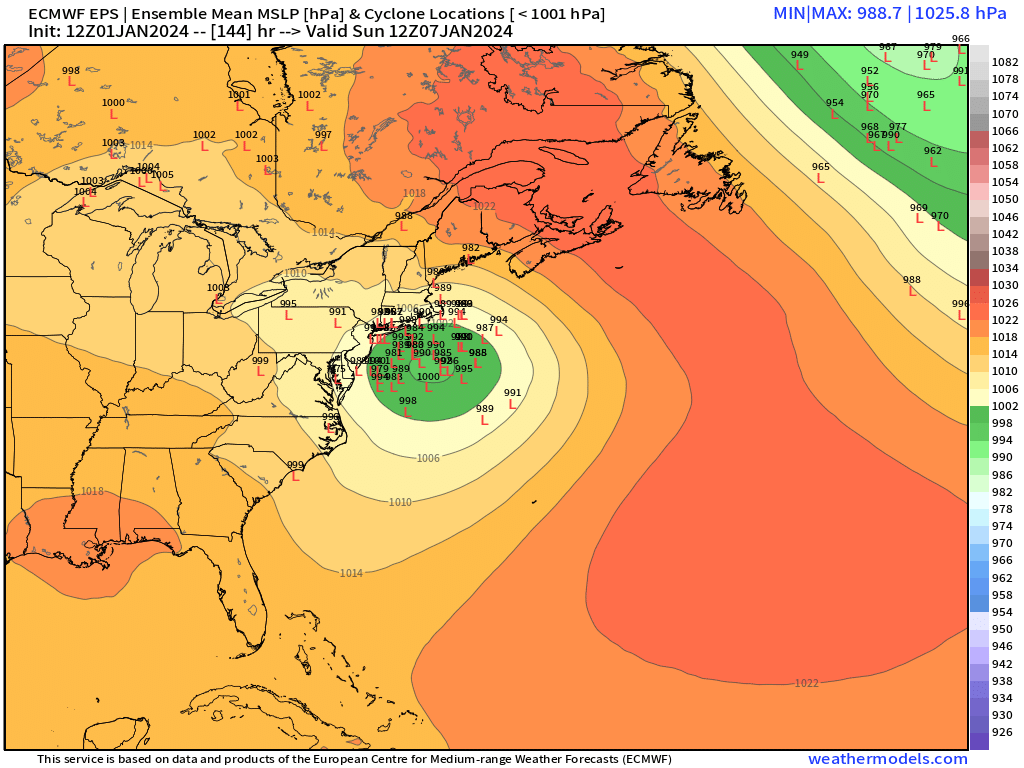
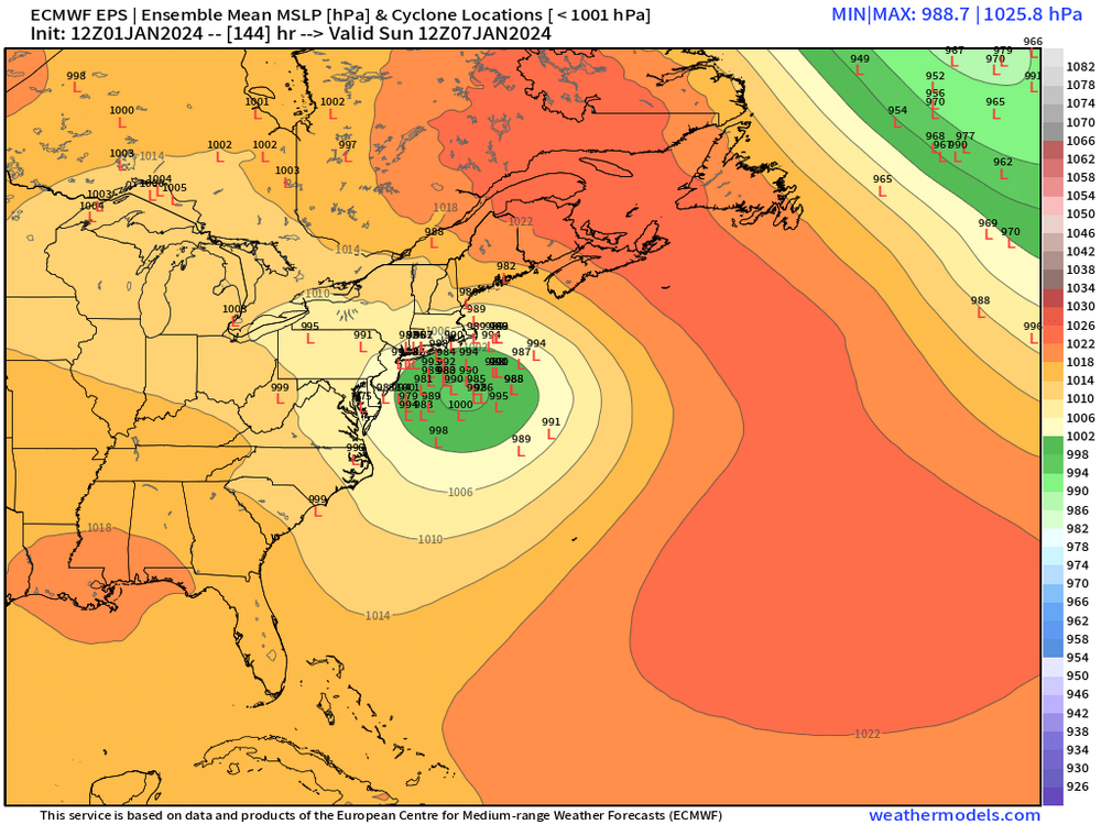
EPS individual ensemble members still have a large cluster that is a closer track

-
Agreed. Those subtle difference is why I’d keep expectations in the moderate range even if we get an ideal track. I do think there will be some double digit totals wherever the CCB meat sets up but as of now, I don’t think those will extend to outside those bands. But we’ll see. Sometimes these southern steamers like to juice up in the final few days.
-
What a weenie run on 06z GFS. That’s how to run the upcoming pattern.
-
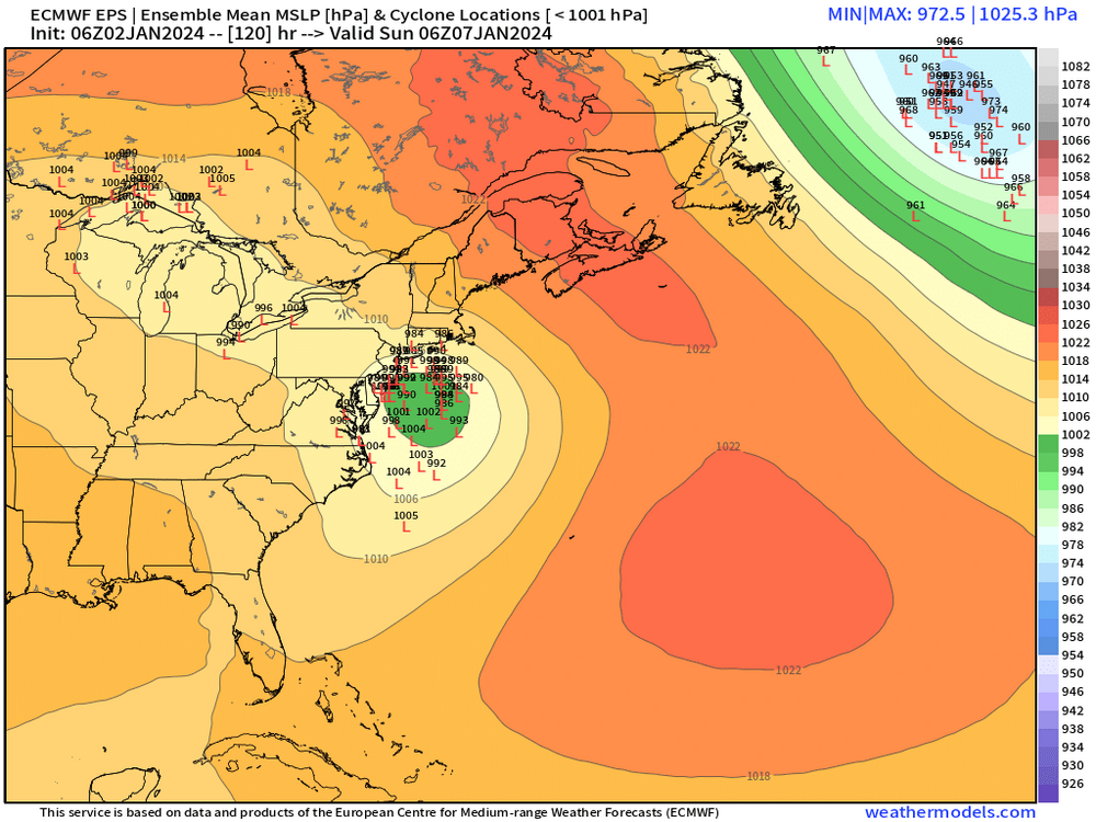
Still a good amount of spread…and still skewed NW
-
That first cutter had huge wind with it that was aided by a line of convection. I remember we had a severe tstorm warning for a big chunk of SE MA…I remember it so well because we drove through it on the way to the Cape that Friday.
-
Yeah it kind of sucks that the EPS right now is about as good as it gets for most of SNE. The extreme NW edge and far SE areas (moreso them than NW) will quibble but outside of that, it’s a great look. It only sucks because it’s 138-144 hours out. But OTOH, you theoretically want ensemble guidance to look good. That way, even if you don’t jackpot, a little trend north or south and you’re still in the game.
-
You got that train of lows from near CHH down to a position a bit W of the BM.
-
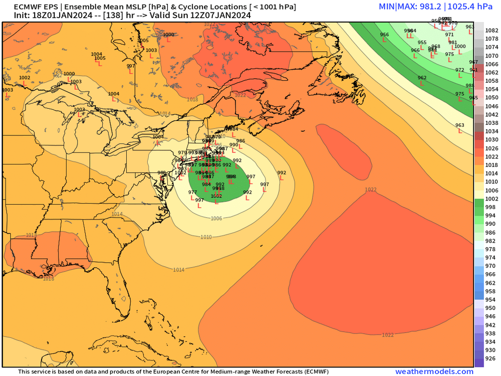
Prob slight tick SE but same vibe. Still spread to NW
-
He said with CAD. That first ‘96 screamer had zero CAD. We were actually quite mild the couple days leading into it. We’ll see on the 1/10 deal, but a lot of guidance shows some CAD even if a couple GFS runs haven’t showed as much.
-
Def still a lot of spread NW of the mean

-
Yes it was. Good memory on that one.
-
Prob a scraper for SNE.
-
MLK 2010 was good in ORH (not so much for Tolland…lol)…those pics I posted of 8-10” of paste triggered Kevin into an all time melt.
-
Give me an example of previous ones. Other than Dec ‘92. Huge pasters aren’t THAT common. They typically are smaller events. Anyways, there’s a long ways to go in this one. Could easily fall apart but today was a good day for model runs since we’re getting inside 6 days now where you’d expect things to start falling apart if they are going to. Hopefully we can keep this strong on guidance for the next couple days and that will get us inside 100 hours.
-
Unless this really hugs I don’t think so. Looks like 20s and powder for much of interior with any offshore track.
-
Yeah this one is gonna reach a certain point and then slide ENE most likely unless the shortwave mechanics change a lot. The good thing about that is it will likely prolong the CCB snows where that happens so it could give us a higher ceiling. The bad news is that it could be frustrating if you’re just north of the goods. You’d keep expecting the heavy bands to get to you but they never quite reach or they weaken by the time they do.
-
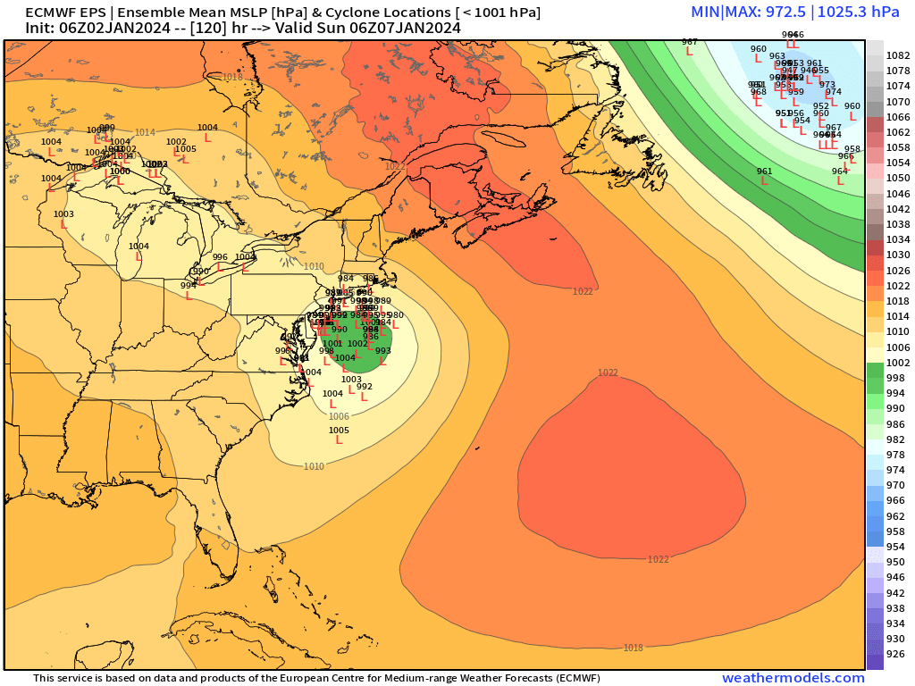
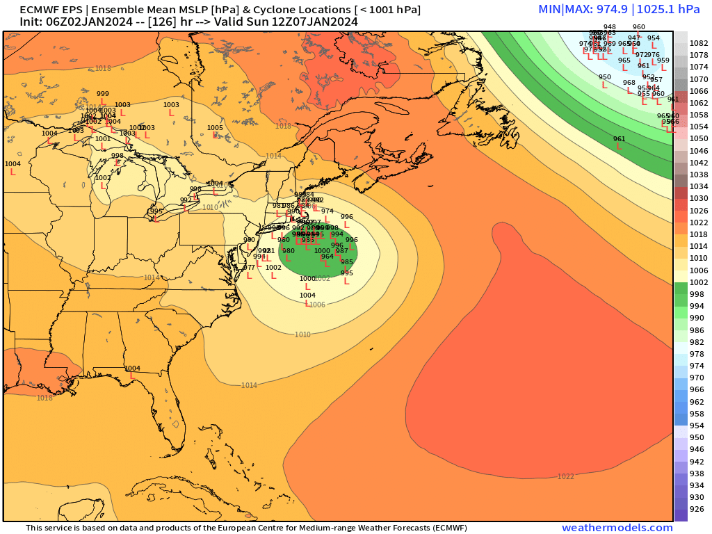
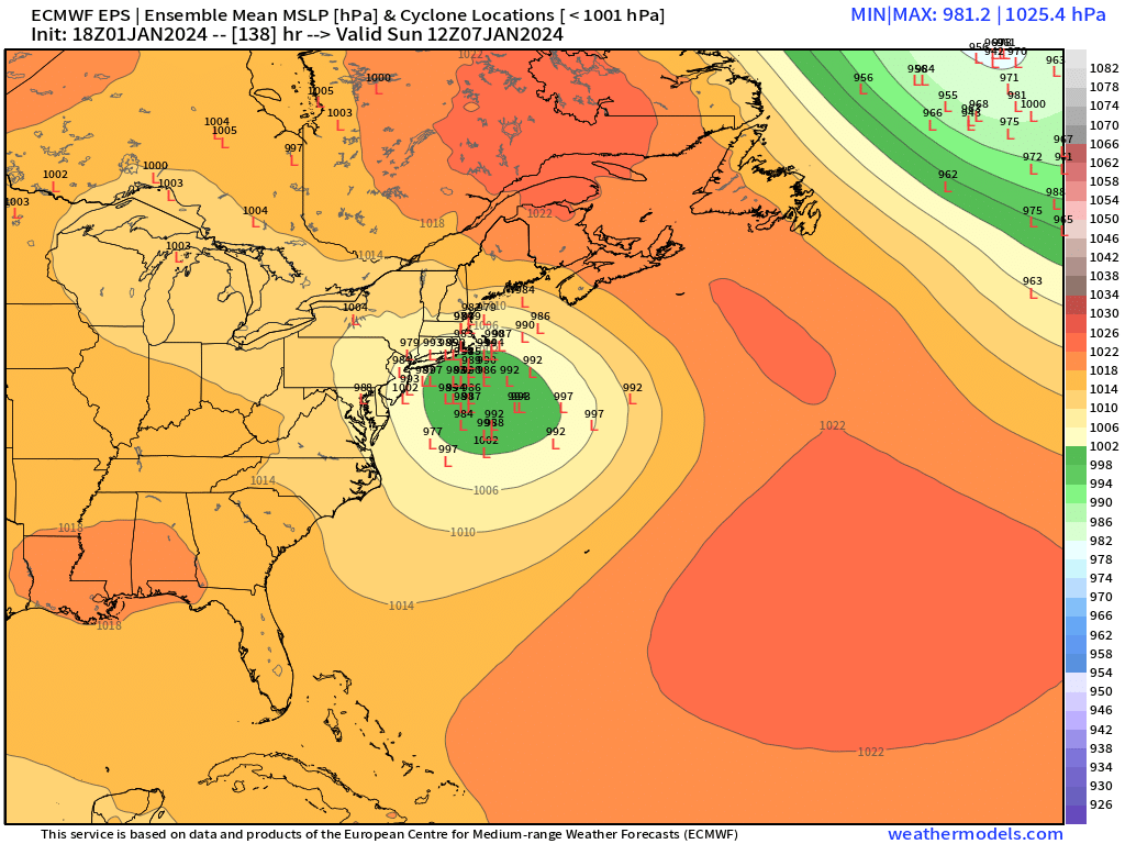
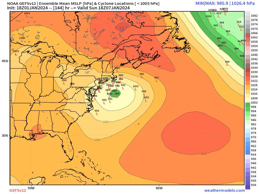
Going to post in here just for archive purposes. EPS clusters below
-
This look reminds me some of Jan 2011…esp prior to the 1/12/11 storm. Big AK/Bering ridge with -PNA and big -NAO block.
-
Check out compared today first Dec ‘96 storm…colder profile in this one but somewhat similar H5 evolution with kicker behind it http://www.meteo.psu.edu/ewall/NARR/1996/us1206.php#picture
-
I’m still not convinced whiff is the primary concern. There is room for this to be too amped too. At 6+ days out though that is going to usually be the case…room for both options.
-
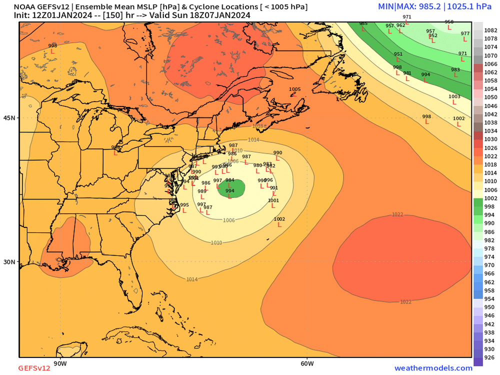
Lot of spread on GEFS.
-
Can’t see the next frame after 144 but that looks like a run from Ray’s computer. Prob near jackpot for his area back to ORH while SE areas struggle with ptype.
-
Ukie is pretty north too. Weird evolution…absolutely torches the Mid-Atlantic despite kind of a coastal track but there’s a lot of energy back in the OH valley so it keeps midlevels from closing off until just south of New England.