

ORH_wxman
-
Posts
90,902 -
Joined
-
Last visited
Content Type
Profiles
Blogs
Forums
American Weather
Media Demo
Store
Gallery
Everything posted by ORH_wxman
-
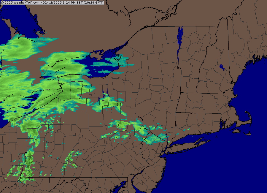
Looks like about 3-4”
-
Euro actually has a decent cold tuck which flips NE MA back to ZR…but it just warms up a bit more prior to that than the GFS so there’s a period of rain. Trend to watch for sure though because a little earlier in the mesolow and it’s lights out over interior.
-
GFS is some for ORH county maybe. That’s a really decent mesolow look.
-
Nothing says big dynamics and front end thump like this regional loop
-
Icon def was cold. But I don’t believe it.
-
The good news about the Euro not coming in today is we can't see how bad it is. Should have us all in a better mood by this evening.
-
That’s prob where you want it at D8. Otherwise it will end up in Ottawa the way this year has gone.
-
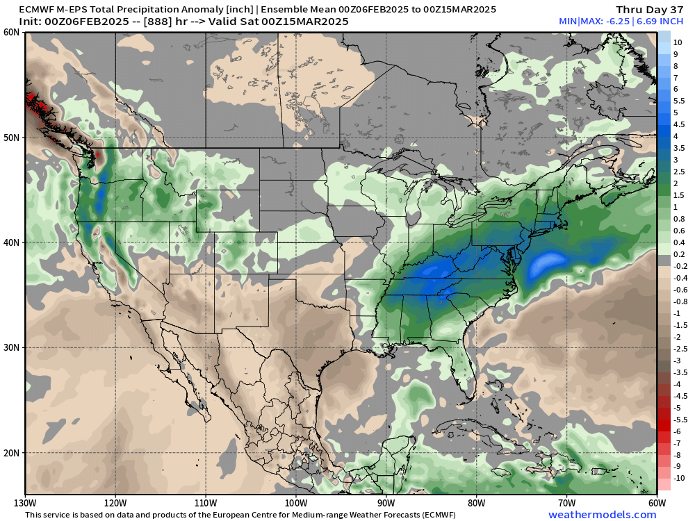
Lol, not on the weeklies…maybe someone else does. I do have a precip anomaly map
-
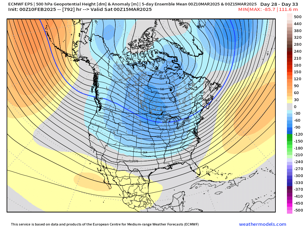
We’ll prob get teased even in the -PNA/+EPO/+AO pattern
-
Canadian is for a good chunk of CNE…maybe even down to northern SNE interior.
-
It’s close to a straight cutter. Still enough CAD to make it a mess but one more tick and we’re just about there…you tick it a little stronger and the secondary reflection will mostly disappear and just show up as kinks in the isobars from CAD. There’s going to be CAD regardless…that happens in straight cutters frequently. Just a matter if we actually get a secondary coastal or not. If we do, then it will hold in the cold at the sfc much better. If not, lots of in-situ CAD but many will warm up to 33-35F rain even if they don’t warm sector cleanly.
-
Starting to look more like euro…almost straight cutter. Give it one more tick and we’re there. Rains to Maine as one man would say.
-
I miss the liftopia days where I could get a 2 day pass to Sunday river for like 90-100 bucks. Now you can’t even get a 1 day pass for that. Cost has gotten insane unless you live close enough for a season pass. Im still going to try and get my boys on skis before winter ends (hopefully in a couple of weekends) but I cringe at the prices now. I think Killington still has kids under 12 ski free if you get a multi-day pass for an adult but not 100% sure. They did fairly recently at least.
-
For those asking about the snow before it gets washed away…yes even the 06z euro dropped 3-5” across much of SNE prior to the main system getting here. But it’s gonna be gone within 18 hours once we warm sector.
-
I’ve seen cutters with monster blocks before. They can happen as long as you phase some TPV in there with a western trough. That’s exactly what we’re getting now.
-
06z euro now 979mb in upstate NY…toucans to Tolland. Ostriches to ORH.
-
PV will prob keep trending west and by the time we get to D3 we’ll be laughing at what was being shown a week out.
-
No 18z was def warmer. Primary was stronger into NY state
-
18z GFS is a little more amped early on and then ends up maybe slightly less so when it passes by us...kind of a similar result to 12z. On a smaller scale, it had the CF further west, so it's not crushing metrowest this run with ice, but ORH county still gets a good hit.
-
Yeah kind of matches my anecdotal memory to my knowledge of ice climo in central MA....feels like that CNE band that was just north of the big boy stuff in 2008 is due for a biggie. I know you studied some of this prior so was curious....thanks.
-
Feb '95 was pretty solid in S NH....not sure how far north the good stuff got. It wasn't historic, but a solid 3/8 to perhaps 1/2 radial ice in spots. Also had a decent icer into S NH in Jan 2007....wanna say 1/15/07 it was. But again, not sure how far north it was contaminated by IP.
-
Not overly exciting but may need to watch for OES pushing east to west tomorrow afternoon/evening ahead of the main system....flow comes onshore and it's pretty cold in that 900-925 range with temps between -8C and -10C in that layer....so easily supports OES ice crystals. A few spots could see a C-1" type thing.
-
He's hitting all the weenie benchmarks recently....tracking every HRRR run for 1-2" of slush last week and then doing the ZFP/point-click fetish for a 5-6 day storm.
-
CNE just got blasted in 2008 (along with parts of SNE).....I'd think that corridor from dendrite in C NH up into CAD-land in Maine is due for a big one though....they were too far north for massive ice in 2008. That area obviously got hit in 1998, but thats working on over 25 years now. That one was obviously historic, but even just a pretty nasty half-inch radial ice storm is likely overdue there. Paging @OceanStWxfor ice storm climo.
-
Prob take the under almost everywhere on that map. Maybe monadnocks reach 3".


