baltosquid
-
Posts
597 -
Joined
-
Last visited
Content Type
Profiles
Blogs
Forums
American Weather
Media Demo
Store
Gallery
Everything posted by baltosquid
-
FV3 is for 95 with the rain snow line. Really want to see some of these mesos stop riding the nw envelope of guidance
-
And we’re all bowing down to our AI overlords
-

January Medium/Long Range: A snowy January ahead?
baltosquid replied to mappy's topic in Mid Atlantic
I am set to arrive 7am 1/11, so if this were to materialize, may need to try to rebook to arrive even earlier… best feeling is being the last plane in. Worst is being the first one to get shafted. -
A heavy squall before heading to AZ would be nice, would at least make me feel like I did not totally miss out if we get something bigger in the week to come.
-
The Slip Sliding Away Christmas Eve Event
baltosquid replied to Solution Man's topic in Mid Atlantic
Some pings in the morning was all in Baltimore. Takes title for closest it's been to a white christmas in some time though, pretty much by default... "yay?" Edit: Actually turns out there's maybe some mangled "accumulation" on the deck, seems mostly like a sparse layer of sleet but maybe there was a brief period of snow earlier -
January: Medium/ Long Range: May the Force be with Us....
baltosquid replied to Weather Will's topic in Mid Atlantic
Of course I’m traveling on the 4th and will not be back until the 11th. Hopefully there’s a welcome home storm in the cards (after touching down of course). -
Light snow at APG!
-
I'd just like some mood flakes to get things started. Durable accumulations east of the mountains for this weekend are off the table, but maybe there will be a few scattered heavy flurries trailing down from the PA border that juuuust make it to 95.
-
Best photo of Thursday, during the 10pm substorm. Washed out in the city but was still very much naked eye visible though fainter. Only caught a bit of the 7:30 substorm which seems like it was the strongest but overall what a night!
-
I really, really, really hope this can stay clear of Haiti. Just can’t bear to watch them continue to catch every bad break.
-
Not my pic but close by. Seems like we did indeed get caught under a tiny vortex.
-
It’s a branch massacre over here. Adirondack chairs thrown about, some shutters yanked off facades as well. Edit. We appear to have been gifted some cushions on the deck…
-
People up 95 should be on the lookout, hook still seems to be present
-
Damn. I think the rotation passed very close to us here in canton just after the rain passed. Got incredibly and chaotically windy and got some power flickers. Seems done for now…
-
Radar presentation of the storm about to come through Baltimore has a pretty clear hook echo
-
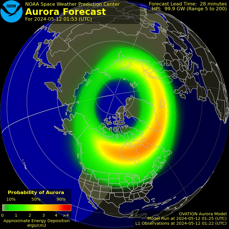
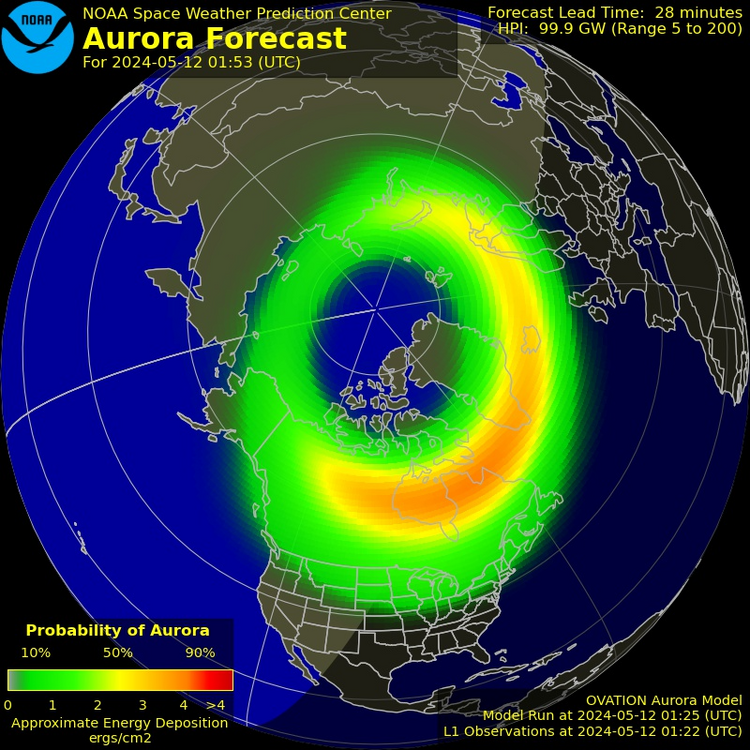
Hp30 index climbed to 7.333 briefly but has come back down. Saw pics of auroras over Lake Ontario but probably not going to get to us barring a bigger hit waiting in the wings tonight. And of course the clouds are excruciatingly stubborn on top of this.
-
Heating up a bit again. This is about as strong as it got last night before it petered out, so hopefully it doesn't repeat that fizzle. Looks like inclement weather should clear up soon and, for once, we won't be traveling or waiting until 3 and 4 am to see if it is truly happening...
-
Tonight might end up more of a long-exposure, horizon based photography thing in low-light pollution areas - CME does seem to have had an impact based on the auroral oval forecast (and it got a tad stronger last update as well) but it doesn't look close to last night. Hopefully tomorrow is better, seems like it will at least provide a better chance of clear (enough) skies!!
-
Forecast picking back up. Mostly cloudy here, can actually see the moon and some stars through a patch of sky but not placed where I can see the north horizon. Hopefully continues to strengthen.
-
CME modeling has impacts at around 8-9pm and again at 1-2am, my read is see how the first hit affects things. If it fizzles, getting some much needed rest. If we get juiced up again, I’ll stick around…
-
https://x.com/mathewjowens/status/1789256119648428163 Simulation of CME impacts... could have more striking the magnetosphere later today/tonight, and then one could hit Sunday as well. So definitely still possible that the auroras could get juiced up tonight. But clouds will again be a factor.
-
SWPC says we're back at G5 storm level! If that were to hold until tonight, it would once again allow for auroras to be seen IF you can get clear skies, ideally to the north. But once again the cloud situation will be dicey, maybe even worse than last night.
-
Finally getting notably clearer - big giant hole in the coverage right over my head, stars visible, but northern horizon blocked and my DSLR can't pick up any auroras overhead. Think it might continue clearing though. Last few attempts on the deck before I call it a night.
-
More cloud fissures, but not a full break... so close. I've giving it until 2, I don't think the Kp will hold long enough to make 4am work (but I would love to be wrong). There are true breaks in the clouds around me per satellite, but haven't gotten lucky yet.
-
Hp30 & Hp60 - Kp index (gfz-potsdam.de) Basically, similar to kp value, shorter time frame. Pegged at 8 right now still, which means low on the horizon is still possible. But if that pocket of broken clouds does not make its way over here soon, I'll probably head to bed... GONG Farside Images (nso.edu) Wonder if that theorized big spot on the farside will survive until it's got Earth in its sights?