baltosquid
-
Posts
597 -
Joined
-
Last visited
Content Type
Profiles
Blogs
Forums
American Weather
Media Demo
Store
Gallery
Everything posted by baltosquid
-
It could be a nightmare, that's for sure. No one's really thinking about snow in Canton it seems due to the temps today. Target still had shovels galore. And so, I parked my car near the top of an uphill one-way. Hopefully everyone having trouble driving up just slides back down harmlessly... condolences to the cars at the bottom.
-
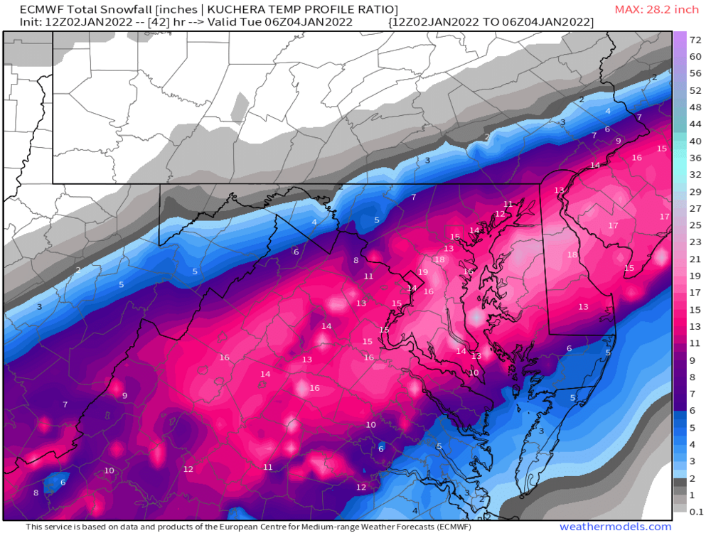
I think I get a handful of images to share per year or something as a goody two shoes with a subscription? One can't hurt... anyway I would echo Chill's comments, the jack looks suspicious between DC and Baltimore, but that's a lot of pink regardless.
-
Kuchera ratios from the Euro destroy I95... 20 inch jackpot between DC and Baltimore, 12-15 for each city.
-
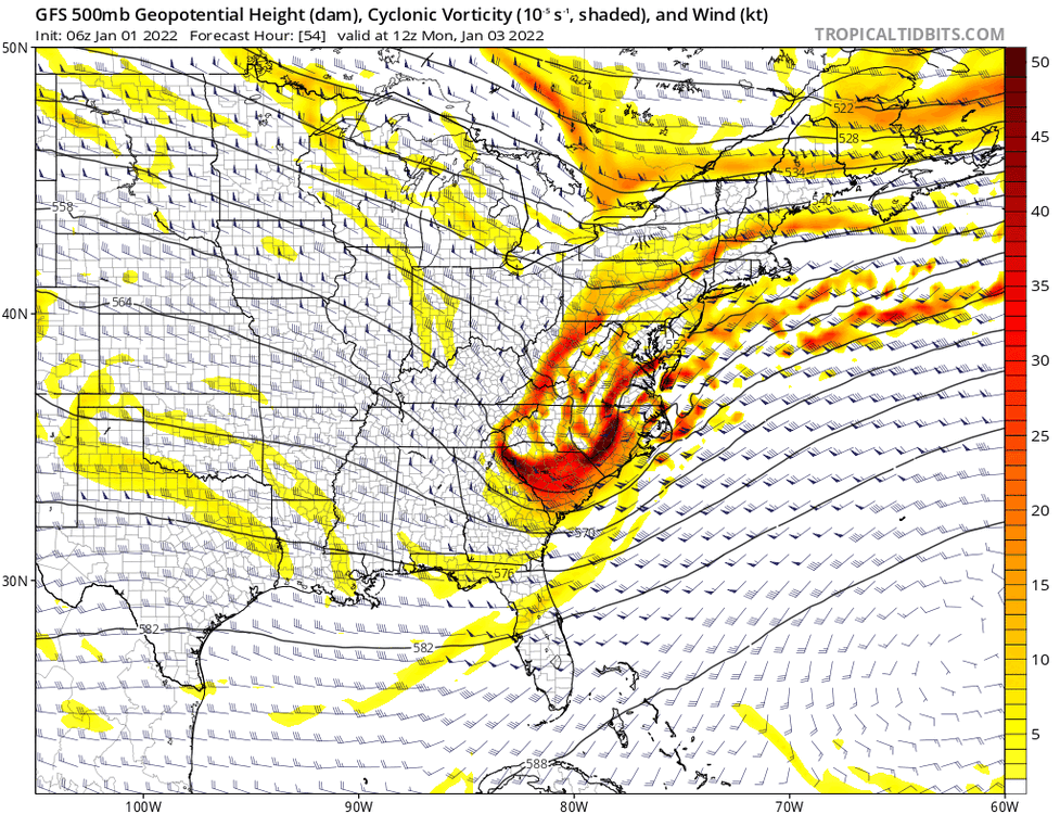
Euro coming through now... h5 looking good. Cutoff is stronger. Tilt is more negative through 18.
-
Forecasters are in a tough spot. If it verifies, it will be easy in hindsight to say "The trend was clearly visible and the GFS had it all along, and the NAM proved to have struggles with it. They should have given everyone a couple more inches on the forecast and moved the warnings north!" But back to the present, got to remember that the GFS is still juicing this more than any other model. So far, that admittedly looks like a decent bet, and it has got all the other models beginning to bend the knee. But it could be wrong in its own way too, and blending still rules, so no one is itching to jump out ahead of the trend. If the trend doesn't continue and follow that leap of faith to catch you, suddenly you're falling.
-
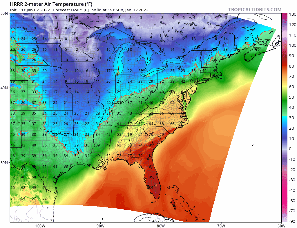
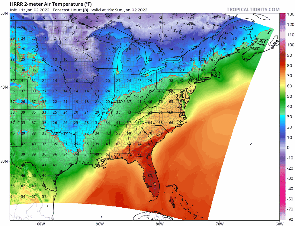
Another cool way to watch the trend... look at the last few HRRR runs. Check out the cold pressing more and more and the distance between the yellows and the freezing line shrinking in the south.
-
Mesmerizing to watch this trend. Just give it a bit more, and juice that shield....
-
One more decent NW jump away from a true I95 transit nightmare…
-
Euro looking more negative tilt through 24…
-

December 2021 Medium/Long Range Discussion Thread
baltosquid replied to North Balti Zen's topic in Mid Atlantic
The GFS is awfully close to getting the northern and southern energy married together over us for Wed/Thu on the 00z run. Too bad it's so dry/meh cold, a storm like that sliding off the coast where the GFS has it would be tantalizing (especially for short pump ) with a few changes. -
December 2021 Medium/Long Range Discussion Thread
baltosquid replied to North Balti Zen's topic in Mid Atlantic
The trend on the ensembles at the h5 level for next week is pretty interesting. All three have some combination of the NS trough digging more, SW to our south getting stronger and the ridging we’re under moving west, allowing some colder air to reach us. Decent agreement on a 50/50 low being around. Ridging continues to retrograde into/over/past Greenland and northern Canada. Just flipping through the past few days’ runs for Wednesday/Thursday, particularly the EPS and GEPS, show how things can look more workable heading towards Christmas, or at least become more winter feeling with less ridiculously high temperatures. Maybe we can sneak in a tracking opportunity before the holidays. Very curious to see if the 12z ensembles continue the trend, particularly the EPS which really wants to build ridging in the west more than the others. If that could come to fruition, despite the strong trough off the west coast we could potentially avoid the worst consequences of that. -
December 2021 Medium/Long Range Discussion Thread
baltosquid replied to North Balti Zen's topic in Mid Atlantic
We are due for a 1996 type January We’re also due for eternal heartbreak! -
December 2021 Medium/Long Range Discussion Thread
baltosquid replied to North Balti Zen's topic in Mid Atlantic
Getting some cross polar flow to start the new year would be great. Worried though that we’d still be stuck with trying to thread the needle with systems like tomorrow’s to take advantage of it. GFS likes a strong Scandinavian ridge just beyond 10 days, maybe that’s the first domino to fall towards getting the New Year pattern change. -
December 2021 Medium/Long Range Discussion Thread
baltosquid replied to North Balti Zen's topic in Mid Atlantic
So if someone more knowledgeable could chime in, I’ve been watching what looks like a little vort that started in far northern Quebec trend further and further southwest (edit: corrected from southeast) for Wednesday through a number of runs now, particularly on the gfs. 12z had it at the south end of James bay around crunch time. If that were to continue, could that potentially influence the storm we’re tracking to head further north? I think I remember last year we lost a storm when a piece of the TPV came down too far and the storm we wanted ended up feeling that and cutting instead. Not sure if that’s in play here. -
December 2021 Medium/Long Range Discussion Thread
baltosquid replied to North Balti Zen's topic in Mid Atlantic
At long range, but the NAM looks like it could have been decent for Wednesday. Cuts off just as the snow starts falling. RGEM is still coming in but also looking like it'll bring snow. -
Next weekend definitely has some interesting features on the ensembles as well. Scandi Ridge is strong and there could be a 50/50 in play. But we get screwed by the PNA leading in to it. If that can relax a bit and we start out with colder air it could maybe happen. There's a very marginal snow signal on the 24 hour EPS snowfall charts.
-
Feb Long Range Discussion (Day 3 and beyond) - MERGED
baltosquid replied to WinterWxLuvr's topic in Mid Atlantic
GFS with a small event, coating to 2 inch across the region, for next Wednesday. Para does not show the same, though. Ensemble h5 look is a bit better compared to 06z. -
(39.289920,-76.583591) The pagoda is close enough
-
As quickly as it switched back to snow, changing to sleet/rain now.
-
Snow is back and heavy at Patterson Park
-
Radar CC indicates change is coming in Baltimore. Flakes have gotten way smaller. Roads just beginning to cave around Patterson Park.
-
Coming down pretty hard at Patterson Park! Don’t have my own equipment but wunderground’s nearest station is down a degree to 32. What a pleasant morning so far.
-
Feb Long Range Discussion (Day 3 and beyond) - MERGED
baltosquid replied to WinterWxLuvr's topic in Mid Atlantic
So we've got the euro taking next Friday's snow south, GFS getting some snow in here before petering out, Para with dry cold, CMC with a harrowing R/S line through DC, and ICON with a flush hit. Honestly, a week out, not the worst signal for the possibility of something maybe lurking. If it survives the weekend, it'll be worth talking more in depth about. For now though it does not exist in my expectations. -
Feb Long Range Discussion (Day 3 and beyond) - MERGED
baltosquid replied to WinterWxLuvr's topic in Mid Atlantic
12z RGEM still a nice event for MD sans Eastern Shore down to DC latitude, 3-6 for most. Still think it's weenie to expect this kind of storm to bring more than an inch or two if anything but it's more believable than the 6-8 inches of the 06z run. -
That was the RGEM, had 30 plus inches for baltimore 2 or 3 runs in a row lol.