baltosquid
-
Posts
597 -
Joined
-
Last visited
Content Type
Profiles
Blogs
Forums
American Weather
Media Demo
Store
Gallery
Everything posted by baltosquid
-
I’m primarily an Eagles fan but ever since studying up in Rochester and making some great friendships with Bills fans, they’ve been the only team that can come close to my level of support for Philly. Heart’s broken for Josh Allen and my friends, just such a disappointment. Gotta take solace in the fact that Allen is an absolute miracle worker with ice in his veins, I guess.
-

Late January and February Medium/Long Range Discussion
baltosquid replied to WinterWxLuvr's topic in Mid Atlantic
I’d certainly take some Sunday night mood flakes before going back to work, as long as no models spits out totals that get my hopes too high before something more reasonable happens. -
Late January and February Medium/Long Range Discussion
baltosquid replied to WinterWxLuvr's topic in Mid Atlantic
Good point, I’ve not been around long enough to be fully familiar with the dynamics here but it’s obvious to me that Chill’s too chill for us to tolerate chilling comments towards them -
Late January and February Medium/Long Range Discussion
baltosquid replied to WinterWxLuvr's topic in Mid Atlantic
Ignore campaigns don’t work because we’re all to some extent craving that sweet sweet no-snow depression, and the downer/contrarian posters are the best providers- 4,130 replies
-
- 1
-

-
- prime climo
- cold canada
- (and 1 more)
-
Thursday 1/20/22 Stat Padder Discussion and Observations
baltosquid replied to stormtracker's topic in Mid Atlantic
Spoiler: we did not and will not reach the best case here in Canton. Still raining. Feels like any other anafrontal system… pretty embarrassing failure by the American models, mesos, global and ensemble alike. I will say the FV3 hi-res was toying with a steeper angle to the front and thus little to nothing for a bit but ultimately it gave up on that and went back to seeing snow. Oh well, I guess I’ll just try to be mindful of the icing threat once things finally cool down. Congrats to those who managed to scrape out something from this. -
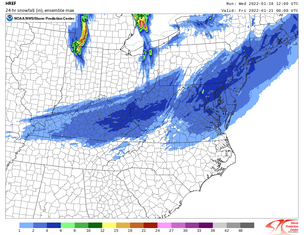
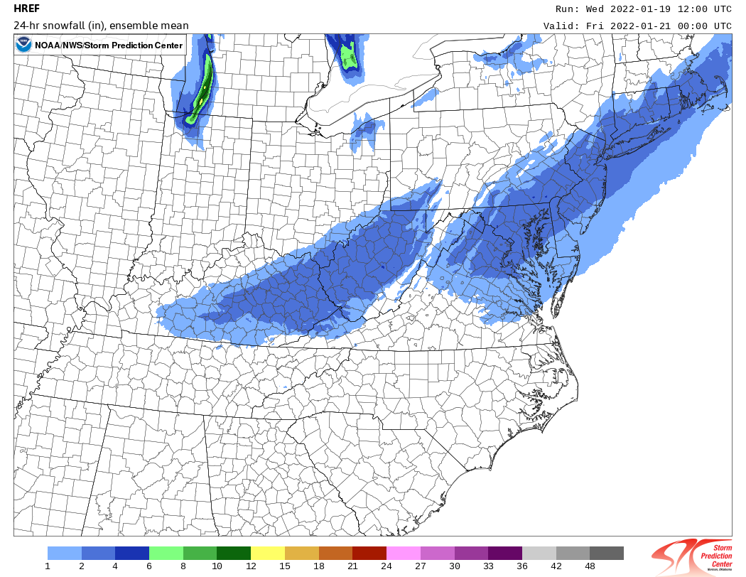
Thursday 1/20/22 Stat Padder Discussion and Observations
baltosquid replied to stormtracker's topic in Mid Atlantic
From the wonderful HREF ensemble site, mean and max: It feels like this particular product is not usually so blanket acceptable in its output for setups like this, so I feel pretty optimistic we can get to the 2 inch mark (Edit: in the metros is my context here). And I'll be curious to see if any jackpotting happens around the green area highlighted by the max map.

-
Thursday 1/20/22 Stat Padder Discussion and Observations
baltosquid replied to stormtracker's topic in Mid Atlantic
The 12z HRRR looks like a bit of a step back so far. But we're still well out of the generally intended use range lol. Probably going to jump back and forth for a bit. This evening's runs when we finally get the whole event in the 18 hours will be fun for weenie trend watching. -
Thursday 1/20/22 Stat Padder Discussion and Observations
baltosquid replied to stormtracker's topic in Mid Atlantic
Someone's gonna find themselves under a short, small streak of heavy snow towards the end of the event when the column is colder and the ratios are better, and they will be the one who gets out with the 3+ inches imo. For those of us who only get the heavier stuff near the changeover, it'll be a somewhat sloppy inch or so and then a light powdery layer on top. At least that's how I think it will go down. -
Buy some calls/puts on natural gas?
-
Lol weenie dream towards the end of the Canadian run.
-
Takes "Diurnal initialization sensitivity", puts in pocket for future coping.
-
Unfortunately RGEM held the vort back more this time as well. Could be a downer 12z when the Euro comes in but hey maybe if the GFS is so good now, it could be keying in on something Sunday to cheer us up!
-
Nam isn't too far away, things just happen too late. Definitely moving in the right direction. Still too far southeast for most of us, 95ish probably would have been furthest NW extent of flakes or just too far to get anything, but hopefully the start of a trend.
-
Well, I think this guy was a real pro.
-
If we're blending, things look quite good. But I am giving some serious stink eye to those EPS members that go up the bay. Don't need another trend into a Harrisburg hauler! BUT if that did come to pass, it seems like the track would support longer snowfall before any changeover, and it seems less likely this would ride all the way up to western NY and would rather eventually scoot off the coast, so maybe that nets us a snow, rain, snow event. Standard terms and conditions with back end snow apply, all purchases final.
-
Thursday 1/20/22 Stat Padder Discussion and Observations
baltosquid replied to stormtracker's topic in Mid Atlantic
Is there any reason this system would prevent/reduce the likelihood of the second? I don't know enough about how this would interact. Does it become a spacing issue if there's too much energy in the first one or something? Or just superstition? -
Thursday 1/20/22 Stat Padder Discussion and Observations
baltosquid replied to stormtracker's topic in Mid Atlantic
Tracking frontal systems with brief rain before similarly brief back end snow just feels like watching whiffs in the making, but I would take some mood flakes during the work day all the same. Even if the best case is 1 inch, that should stick around given there's a chance we don't crack 30 degrees for a couple of days afterwards! -
Unsalted surfaces caved pretty much immediately in Canton a few hours ago, but now salted surfaces are also turning white. Seems like there's another hour or two before the mixing hits. Hoping that yellow on the radar reaches up here! Looks like there's around or a bit under an inch right now but I don't have an actual measurement.
-
Oh, those halcyon days when we were fretting a southern slider. Well, 2/3 ain't so bad. Just fun tracking now, in a tragic sort of way lol.
-
I don’t think we get shafted quite as badly as the NAM shows but 18z could definitely be the set of runs that crystallizes this as a 3 inch ceiling for the 95 corridor. Seemed liked 3-6 wasn’t out of the question but that diving NS is not going to have it. Gotta make peace with that. Oh, and don’t forget urban heat island effects…
-
CMC and Euro demonstrate once again, as has been mentioned by smart folks, unless the NS backs off last minute there is not much influence to be had over the ultimate fate of the storm through other factors. That phasing is just so strong. Both models had significant jumps East with the h5 low for the first 72 hours and it really only marginally affected the storm track in the end. Even with what looks like a very nicely timed neutral tilt (could even be considered late, compared to last Monday) we can’t buy much time west of the low along 95. Just have to hope that piece is overdone.
-
Not convinced the SE jump will help us at hour 72. Looks stronger, more neutral and cutoff. Might have a harsh left turn like the CMC, but would be glad to whiff on that thought.
-
There is a low in the south next Wednesday on GEFS but there’s no impetus for it to really develop and come up our way. Just gets bullied off the continent. But it’s there. Maybe it finds a path northward.
-
Lol never mind. Did not lighten up on that at all, phasing happens fast and swings the thing way west. Low never even gets east of DC.