baltosquid
-
Posts
597 -
Joined
-
Last visited
Content Type
Profiles
Blogs
Forums
American Weather
Media Demo
Store
Gallery
Everything posted by baltosquid
-

Late January and February Medium/Long Range Discussion
baltosquid replied to WinterWxLuvr's topic in Mid Atlantic
This model is living in weenieland
- 4,130 replies
-
- 2
-

-
- prime climo
- cold canada
- (and 1 more)
-
Late January and February Medium/Long Range Discussion
baltosquid replied to WinterWxLuvr's topic in Mid Atlantic
Another model question... what is the GFDL C-Shield? Just more FV3 experimentations? It says snow depth post-storm will be 2-4 inches for Baltimore -
Late January and February Medium/Long Range Discussion
baltosquid replied to WinterWxLuvr's topic in Mid Atlantic
It's all based on the FV3 core now, global included. FV3-HiRes, if I am not mistaken, is an in-development mesoscale model based on the same physics as the new GFS that will eventually supersede the NAM and be the basis for mesoscale ensembles. But I could be dead wrong, I don't really get much up to date model development news.- 4,130 replies
-
- 3
-

-

-
- prime climo
- cold canada
- (and 1 more)
-
Late January and February Medium/Long Range Discussion
baltosquid replied to WinterWxLuvr's topic in Mid Atlantic
Euro makes the coastal out to be a high end advisory result for those in the right path, but not super widespread. But everything’s picking up on a wave taking some sort of path around the area in that timeframe, more importantly. -
Late January and February Medium/Long Range Discussion
baltosquid replied to WinterWxLuvr's topic in Mid Atlantic
True, I have been thinking today that the opening act is close to lost but there’s a lot of run to run variation on the western end of things. And even for the first portion, this was an entirely different setup, but I think the early January harsh cutoff storm was reeled in on even shorter notice. There’s at least some hope! -
Late January and February Medium/Long Range Discussion
baltosquid replied to WinterWxLuvr's topic in Mid Atlantic
Coastal picked up by euro afterwards at least, not very strong though and temp concerns. -
Late January and February Medium/Long Range Discussion
baltosquid replied to WinterWxLuvr's topic in Mid Atlantic
Depending on how much snow you’re dead-set on, you’re gonna need at least a couple hundred miles’ shift SE. Even more if you’re holding out hope to get the Thursday night stuff rather than just a small Friday piece. Can’t say it’s impossible, but I’m near the point of rooting for the euro solution over getting stuck so close yet so far with an ice storm, just to avoid that nightmare of a commute for myself and everyone else. -
Late January and February Medium/Long Range Discussion
baltosquid replied to WinterWxLuvr's topic in Mid Atlantic
Thank goodness 2 of those days would be the weekend -
Late January and February Medium/Long Range Discussion
baltosquid replied to WinterWxLuvr's topic in Mid Atlantic
Looks like almost an inch of freezing rain for the I95 corridor… big yikes. Could wreck evening commutes. Edit: and morning commutes too potentially but hopefully it won’t be piling up on the warm end of the event.- 4,130 replies
-
- 1
-
-
- prime climo
- cold canada
- (and 1 more)
-
Late January and February Medium/Long Range Discussion
baltosquid replied to WinterWxLuvr's topic in Mid Atlantic
At this point I wonder if I’d prefer to see things more inland lol, we keep leaving snow on the table with things trending to our SE with the exception of that Harrisburg hauler. Feels like the playbook this year has been “op runs sets a storm up off shore in med-long range, it trends in, then trends out” -
January 28-29 2022 Miller abcdefu Storm Obs/Discussion
baltosquid replied to mappy's topic in Mid Atlantic
Feels like we’re still deep in the screw zone in Baltimore… the amount of flakes falling is a bit higher than it was an hour ago, but it’s still only dust. Only a grassy surfaces and car topper event so far. Just hoping we can cover the grass by tomorrow at this point but I am not convinced that’s in the cards. Seems like we might get the very marginal dark greens (looking at COD radar) soon, so let’s see if that can turn our fortunes around. -
January 28-29 2022 Miller abcdefu Storm Obs/Discussion
baltosquid replied to mappy's topic in Mid Atlantic
Snow petering out in Canton for now it would seem. -
January 28-29 2022 Miller abcdefu Storm Obs/Discussion
baltosquid replied to mappy's topic in Mid Atlantic
Snow's picked up in Canton. Feeling sufficiently wintery to pour a Lost Generation Stout. Radar looks to be improving but I am worried about getting stuck in between of the two stronger bands around me, hopefully the stronger stuff fills in here, too. -
January 28-29 2022 Miller abcdefu Storm Obs/Discussion
baltosquid replied to mappy's topic in Mid Atlantic
Light flakes in Canton. -
January 28-29 2022 Miller abcdefu Storm Obs/Discussion
baltosquid replied to mappy's topic in Mid Atlantic
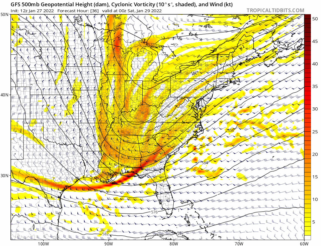
GFS over the last day. Too little too late to help west of the bay to any large extent I think, but if the h5 keeps trending like so I imagine the coast would be more likely to achieve the high end of the forecast as we transition to the coastal low portion of the event.
-
January 28-29, 2022 Miller abcdefu Storm Threat
baltosquid replied to WxUSAF's topic in Mid Atlantic
By 42 that's all she wrote for the subforum pretty much. Seems like a very similar run, a little bit worse. Started out looking okay but the storm just moves too fast. -
January 28-29, 2022 Miller abcdefu Storm Threat
baltosquid replied to WxUSAF's topic in Mid Atlantic
Okay so by 36 a clear problem has arisen; it just gets pushed out too fast. Even with a marginally better low placement, we end up missing out on more of the coastal it seems since it scoots. -
January 28-29, 2022 Miller abcdefu Storm Threat
baltosquid replied to WxUSAF's topic in Mid Atlantic
Anyway... euro through 24 looks pretty decent, better precipitation up front and low placement. Seems like h5 was marginally better. Not gonna radically alter things but maybe a nice baby step towards more secure totals for the subforum. Edit: Doesn't seem like much of the coastal snow will have any shot of getting west of the bay at 30, though. Just dries up too fast. Always good to be skeptical of the coastal snow... -
Late January and February Medium/Long Range Discussion
baltosquid replied to WinterWxLuvr's topic in Mid Atlantic
We might reach climo in Baltimore this year which is a nice change but until we finally break the warning criteria drought, can’t go better than a C! Hopefully if we get into a boundary runner setup, we have enough tickets in that lottery to make one score like the GFS depicts. But it’s a long way away, say your goodbyes to it before the 12z…- 4,130 replies
-
- 1
-
-
- prime climo
- cold canada
- (and 1 more)
-
January 28-29, 2022 Miller abcdefu Storm Threat
baltosquid replied to WxUSAF's topic in Mid Atlantic
If the GFS ends up caving in the morning after a run like that, it'll have "Flowers For Charlie" vibes.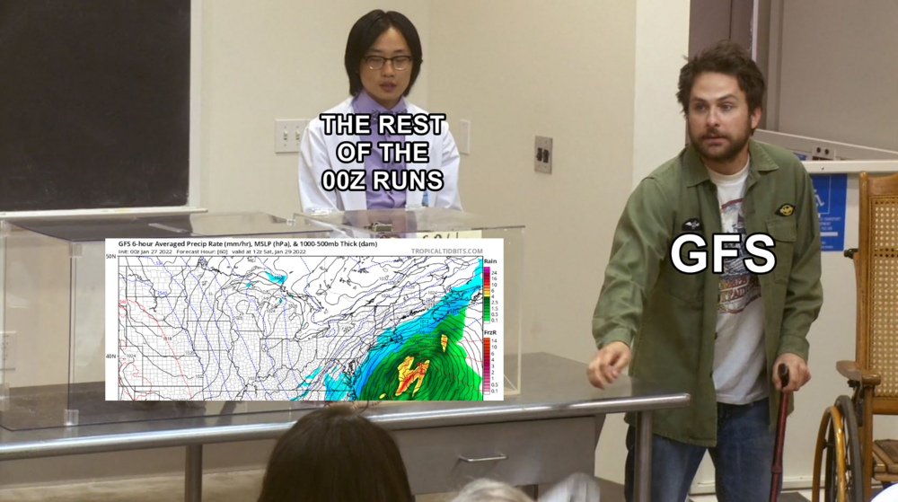
-
January 28-29, 2022 Miller abcdefu Storm Threat
baltosquid replied to WxUSAF's topic in Mid Atlantic
FWIW the h5 look catches up with 18z in many respects by 54, but by then it's too late to help us and is still further east, and the low has already gone well wide right. Bad run. No Jaws. -
January 28-29, 2022 Miller abcdefu Storm Threat
baltosquid replied to WxUSAF's topic in Mid Atlantic
It's not HUGELY different from 18z at 45 on h5 vort look, but the large majority of ways in which it is SMALL-LY different are bad. -
January 28-29, 2022 Miller abcdefu Storm Threat
baltosquid replied to WxUSAF's topic in Mid Atlantic
Looks like negative changes through 30. The placement of the southwest vort isn't much different, but less interaction with the northern stream, which digs less. Unless there's a huge shift in how things develop past the Mississippi river, early returns are not looking to support improvements. -
January 28-29, 2022 Miller abcdefu Storm Threat
baltosquid replied to WxUSAF's topic in Mid Atlantic
Jaws meter comes out if and only if the GFS makes a strong adjustment towards the coast as the mesos and ICON have done . Until then, gotta remember what psu said - this is all bouncing around the goalposts we already were familiar with. As for the RGEM specifically, I will probably never trust that model after the 30 something inch run it had for Baltimore a few days before that multi-day storm last year, think it was the late January one. -
Apologies for any undue encouragement of banter-y jaws stuff with the meter yesterday, that creation will live here from now on, at least when the threats are as contentious as this one has been!