baltosquid
-
Posts
597 -
Joined
-
Last visited
Content Type
Profiles
Blogs
Forums
American Weather
Media Demo
Store
Gallery
Everything posted by baltosquid
-

Jan Medium/Long Range Disco: Winter is coming
baltosquid replied to stormtracker's topic in Mid Atlantic
So GFS/Euro heading in the right direction, CMC still heading north but not drastically. Really good day so far... I'm very close to my personal "delay putting away Christmas decorations" line, let's go 12z! -
First flakes courtesy of this pellet snow, at work in Aberdeen! Not a bad start to the day.
-
Not going to hold my breath on the NAM look here, BUT if I'm not mistaken one of @CAPE's big hits last year was a storm that looked certain to be OTS/too far north (can't remember which way the globals had it) and was first brought back to us by... the NAM 12km.
-
Trend on the GFS. More alignment. But staying at arm's length from each other. Don't they know it's cuffing season?!?
.thumb.gif.a52c6895abff26c725b03075ccab2913.gif)
-
December 22-23, 2022: Warm Rain to Arctic Chill
baltosquid replied to WxUSAF's topic in Mid Atlantic
If it somehow were to go down like that, it would be a miracle and would give a lot of us a shot at a White Christmas with the cold behind it. But I just can't trust that anafrontal stuff... -
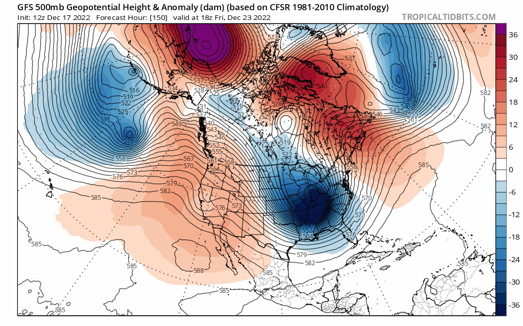
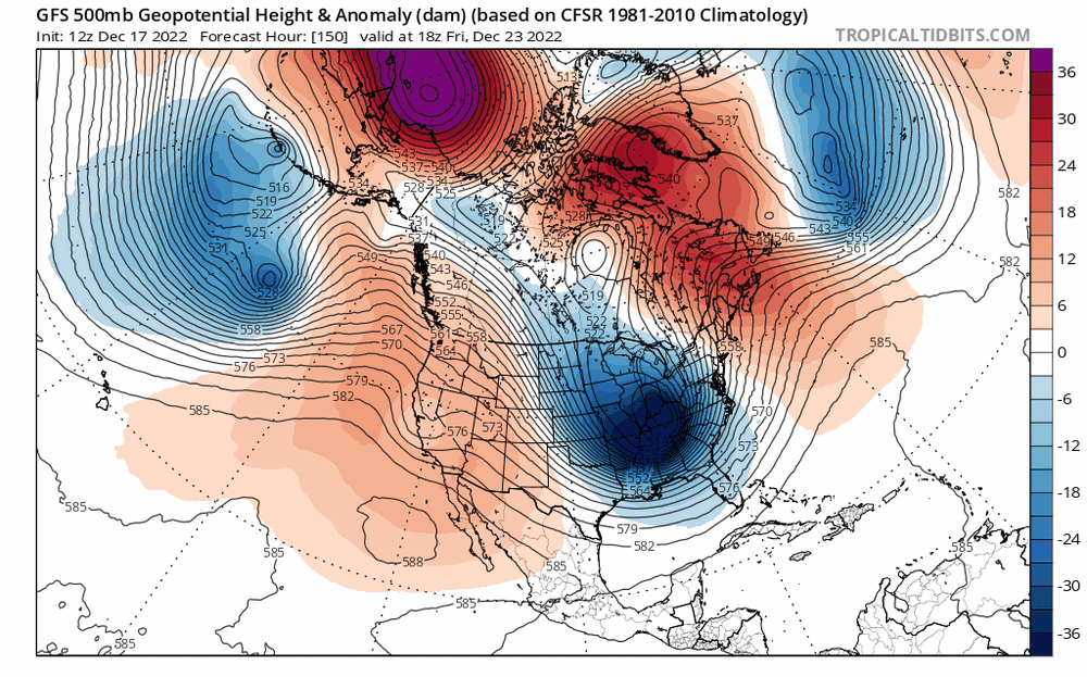
But conversely, the TPV (minus anomalies in Canada) is getting its fingers deeper and deeper into the cookie jar with each run, and the low in the north Atlantic is moving away. Trace clockwise circles around the red and counter-clockwise around the blue... our storm is right in the middle of two features that want to send it on a 0-degree heading.
-
That ridge is screaming dig.
-
We cannot afford a blocking gap!
-
3/12 Event: Winters Last Hurrah at Least East of Mountains
baltosquid replied to Weather Will's topic in Mid Atlantic
Zero accumulation in Canton, outside of a dusting on garbage bins. Nothing really falling right now. Don't think anything will come of this unless a good heavy band comes in with whatever manages to fill in, but that would probably only leave the area with a dusting. Batting .000 with anafrontal systems this winter... and most winters. At least some of the heavier sideways stuff has been nice to watch. -
3/12 Event: Winters Last Hurrah at Least East of Mountains
baltosquid replied to Weather Will's topic in Mid Atlantic
Pingers in Canton, looks like the changeover is coming fast -
It did not get there in Canton, was around 3-4 inches. Areas further south still within the city borders potentially could have eked it out but I don't think the gradient was steep enough. Same deal for the end of week storm.
-
ONE YEAR AGO: The "Spring Snowstorm of 2018" (wmar2news.com) The more I'm researching it the more conflicting info I see. Some places report warning criteria, others not. Guess it varied backyard to backyard. My backyard probably didn't actually break warning criteria based on these totals, though other parts of the city did. Which would mean I haven't seen a warning snowfall since moving to Baltimore a month before that storm, and Baltimore hasn't gotten a flush verified warning criteria snowfall since 2016 I think.
-
If I'm not mistaken the last verified warning criteria storm in Baltimore was March 20th, 2018. If we do get a good event in March to break that drought, it would be a nice "time is a flat circle" moment.
-
Pretty damn strong Alaskan ridge signal at range on the GEFS. The southern ridge is pretty stubborn, but weakening run to run.
-
Impressive snow showers while I was driving up 95, between Baltimore and White Marsh. Pavement caved fast. Nice treat for the Monday morning commute. Harder than anything yesterday, too bad the sun will probably melt whatever coating fell in Baltimore by the time I’m home. Wish it had happened with the backdrop of actual accumulation from yesterday but a good mood lifter anyway.
-
Radar looks like it's setting up one last hurrah for Baltimore, snow's picking up again. Just hoping for some more broad accumulation, but almost certainly staying under an inch.
-
Snow's picked up a bit in Canton. Still no accumulation on pavement/sidewalks, just cars and grassy surfaces. But I get to do a couple errands in the snow at least, so that's a nice treat.
-
In Canton, Only cars topped so far. Tiny flakes. Need some sort of band to come through or this will be a bust.
-
FWIW, HRRR 01z looks like more QPF rather than less, or at least a similar amount. Definitely not the disaster the NAMs were.
-
Where do I initial? Full signature at the bottom I assume?
-
6z Euro is a nice 2 inch strip along 95, 1-2 NW of 95, trace-1 SE of 95
-
00z NAM does not look to be an improvement, for what it's worth. Jumped back to a 12z look at hour 69. Lots of energy gets strung out.
-
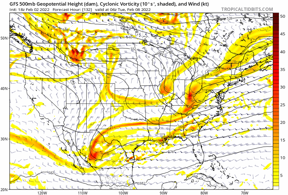
Looks like if the Mexico crossing vort can link up with the NS energy better (as it has been trending on the GFS) we could maybe get some nice Gulf energy to juice things? Too far off to say if it'll have lots of moisture or not but definitely like the potential to tap some warm water energy.
-
Nice trends.
-
Late January and February Medium/Long Range Discussion
baltosquid replied to WinterWxLuvr's topic in Mid Atlantic
Shouldn't have any trouble sticking to an ice rink!

.gif.8b6854a668fbc7e064e770308377392a.gif)