ChasingFlakes
-
Posts
549 -
Joined
-
Last visited
Content Type
Profiles
Blogs
Forums
American Weather
Media Demo
Store
Gallery
Everything posted by ChasingFlakes
-
Man was that a lightning show over SNJ earlier between 8-10pm. Lightning was seemingly nonstop, I had a good bit of time to kill before I could begin work, so we watched the storm off in the distance. Wish I had my dslr for that one. I took some videos on my phone but we were in a lit up parking lot, so they didnt come out too great.
-
Heading back into heavy rain on 55 near Woodbury as I head for a job in Millville tonight. Didnt get much back home aside from some rain and thunder. The stronger stuffed passed just 5-10 miles to my southwest. Edit: just as I posted that lightning struck a tall utility pole off the side of the highway just in front of us. It was really bright, I was looking right at it so I feel blinded now. Theres alot of cloud to cloud lightning as well. Looks impressive on radar.

-
Heard on KYW that there is possible tornado damage in Morgantown, Pa. Edit: https://6abc.com/weather/damage-reported-in-morgantown-pa-after-possible-tornado/5320726/
-
"Severe Weather Statement National Weather Service Mount Holly NJ 619 PM EDT Tue May 28 2019 PAC029-282245- /O.CON.KPHI.TO.W.0013.000000T0000Z-190528T2245Z/ Chester PA- 619 PM EDT Tue May 28 2019 ...A TORNADO WARNING REMAINS IN EFFECT UNTIL 645 PM EDT FOR CENTRAL CHESTER COUNTY... At 618 PM EDT, a severe thunderstorm capable of producing a tornado was located near Downingtown, or 9 miles northwest of West Chester, moving east at 30 mph. HAZARD...Tornado and quarter size hail. SOURCE...Radar indicated rotation. IMPACT...Flying debris will be dangerous to those caught without shelter. Mobile homes will be damaged or destroyed. Damage to roofs, windows, and vehicles will occur. Tree damage is likely. Locations impacted include... West Chester, Coatesville, Downingtown, Glenmoore, Lionville, Marshallton, Lionville-Marchwood, Paoli, West Goshen, Malvern, South Coatesville, Exton and Thorndale. PRECAUTIONARY/PREPAREDNESS ACTIONS... TAKE COVER NOW! Move to a basement or an interior room on the lowest floor of a sturdy building. Avoid windows. If you are outdoors, in a mobile home, or in a vehicle, move to the closest substantial shelter and protect yourself from flying debris. && LAT...LON 4009 7548 3986 7561 3999 7583 4009 7579 TIME...MOT...LOC 2218Z 291DEG 28KT 4002 7576 TORNADO...RADAR INDICATED HAIL...1.00IN" I'm in charlestown/kimberton area and I have moderate to heavy rain, a good bit of thunder and some lightning. No hail or heavy wind, car is in the garage to be safe.
-
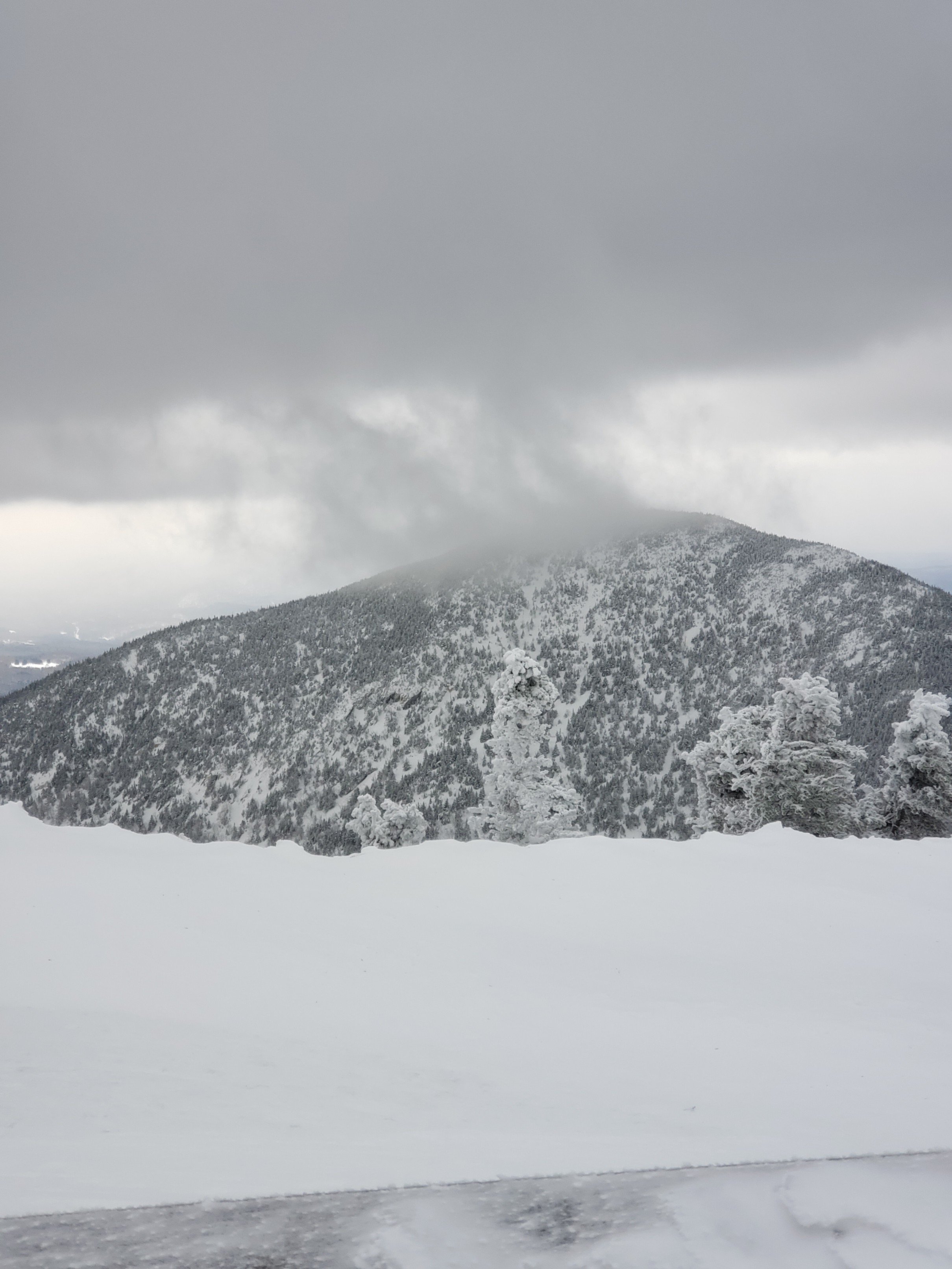
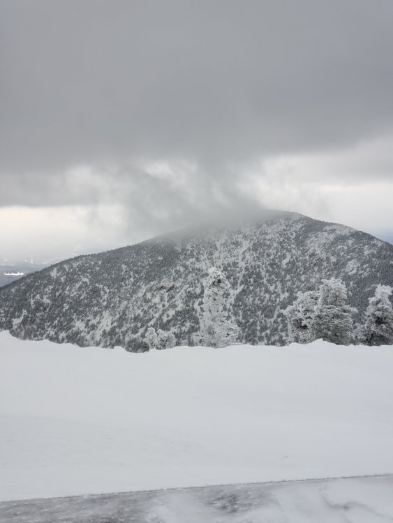
Some footage of myself from last weekend March 23rd/24th and Magic Mountain and Jay Peak, respectively. It was interesting to see the difference in snow cover on the exposed rocks along the upper mountain ridge line at Jay. March 11-13th the ridgeline was completely snow covered with the rocks being covered in rime. On the 24th, at 830am as one of the first to reach the summit for the day, the exposed rocks were completely dry and it looked as if there was about 6” less snow as the week prior, despite receiving 24” both times. Rode for the last last time in PA for the season at Blue Mountain this past Thursday, March 28th. Nothing like riding through brown slush on certain trails, others were actually very nice with a lot of snow on them but the snow was super slow even with relatively fresh warm weather wax.
-
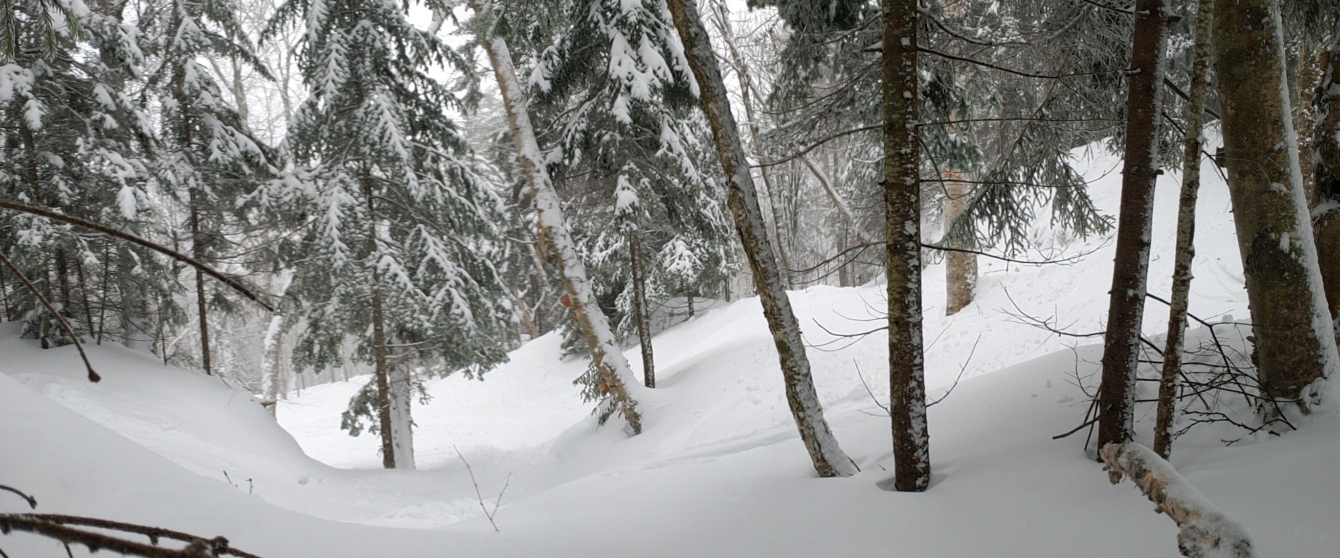
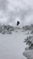
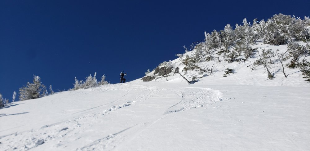
Rode Magic Saturday, I would have gone further north to sugarbush or Stowe but my buddy left his skis and boots in a locker at mount snow, so we had to grab them early in the morning. This is why I dont mind solo trips, stuff like that doesn't happen. Anyways, Magic was nice where there was a base previously or that had not been windblown. The trees held anywhere from 8-12" of fresh from bottom to top. It was definitely loud powder with a scraping hardback under the fresh snow in a lot of places. Sunday I somehow found myself at Jay Peak again, only 10 days after being there solo March 11-13th for 2 feet of dry upslope powder. Coming from the Philly area, I've put 2500+ miles on my car in two weeks. Anyways, the 2 feet they recieved this storm had turned heavy and almost hard packed by Sunday morning, although certain shaded zones or wind deposits stayed dry. This never happened the week before, where it managed to stay dry for at least a full day of bluebird conditions. We hiked the peak Sunday morning on first chair and got fresh tracks on the 'mellow' line skiers right along the shoulder and eventually off skiers left that opens into a steep snow field before entering the trees and a steep narrow chute. Here's a picture looking up the short snow field. You can tell I didnt dig deep into the snow at all. Also, I almost died. I was going fast, about 20-25mph through open trees where it was exposed to wind. Just skiers right of that roped wind exposed death patch of ice/grass under the flyer just before the lift flattens out and dips down up top. I hit a roller and grabbed indy, but when I landed my nose dug under the heavy windblown powder. I slid out onto my stomach at about 15mph, but because the windblown snow was harder at the top, I didnt break through. I slid superman style 15 feet, where there was a nice tree that greeted the back of my head/base of my neck. I was probably going about 10mph at impact. If I had not been wearing a helmet, I would probably be dead. My buckled helmet popped off and in the process gave me a nice bruise next to my eye. My neck and shoulders are a little sore in the muscles, but I was able to ride fine the whole rest of the day and even dropped a good 12 footer afterwards. Overall it was nice, but again, conditions didnt compare to either of the 3 days I was there the other week. Glad I made the journey though as I got more great footage and was able to show my friend a great mountain on a great day. I'll try to share more as soon as my buddy has a chance to dropbox them over to me.
-
Rode magic today, as usual some areas were nice, others were rocky ice-filled death chutes. Got some good footage, will upload later. Up in St. Albans right now, I'll be at Jay tomorrow. Supposed to work early Monday am so may have to bomb back to PA afterwards, or play hookie. Either way it should be another good day at Jay tomorrow as they fast approach 400".
-
Funny thing is I had just met them the run before, I was hiking up to beat the tram line, a group of 4 had the same idea right behind me. We all took an awesome run together down the shoulder. Just so happened I met up with two of them at the top two runs later, I told them I had eyed this line from up top but needed to hike down to check it out. Suprisingly they were down for it. I guine pigged it, and Aiden followed suit as he tried to avoid my bomb hole which had uncovered a buried tree. I ended up skiing with them the rest of the day. They offered to let me crash in NH that night, which cut my drive back to PA the next day. Whenever I do a solo powder trip, I always end up meeting cool people that hook me the hell up! Same thing happened at mount snow and now I have friends that work at the mountain and have a house there. Hard to find good people to ride with coming from PA, so it is nice! Speaking of, I promised the clip of my buddy Aiden taking a nice yardsale in the zone the previous video was filmed. They drop just skiers right of the icefall I dropped. I'm looking back up the 'chute'. He tried to take a nice powder turn, but uncovered the other side of the icefall which had been covered with 1-3ft of dry snow. Unfortunately I wasnt in the best spot to capture his first tomahawk but I got the tail end, he went through a bush/over a small drop. Also thinking of driving up to maybe mount snow this weekend. I'll be done early tomorrow but have to be back for work 5am Monday so I dont think anything further than SVT is on the table, despite the forecast for another awesome right side up 2ft+ snowfall in NNE..
-
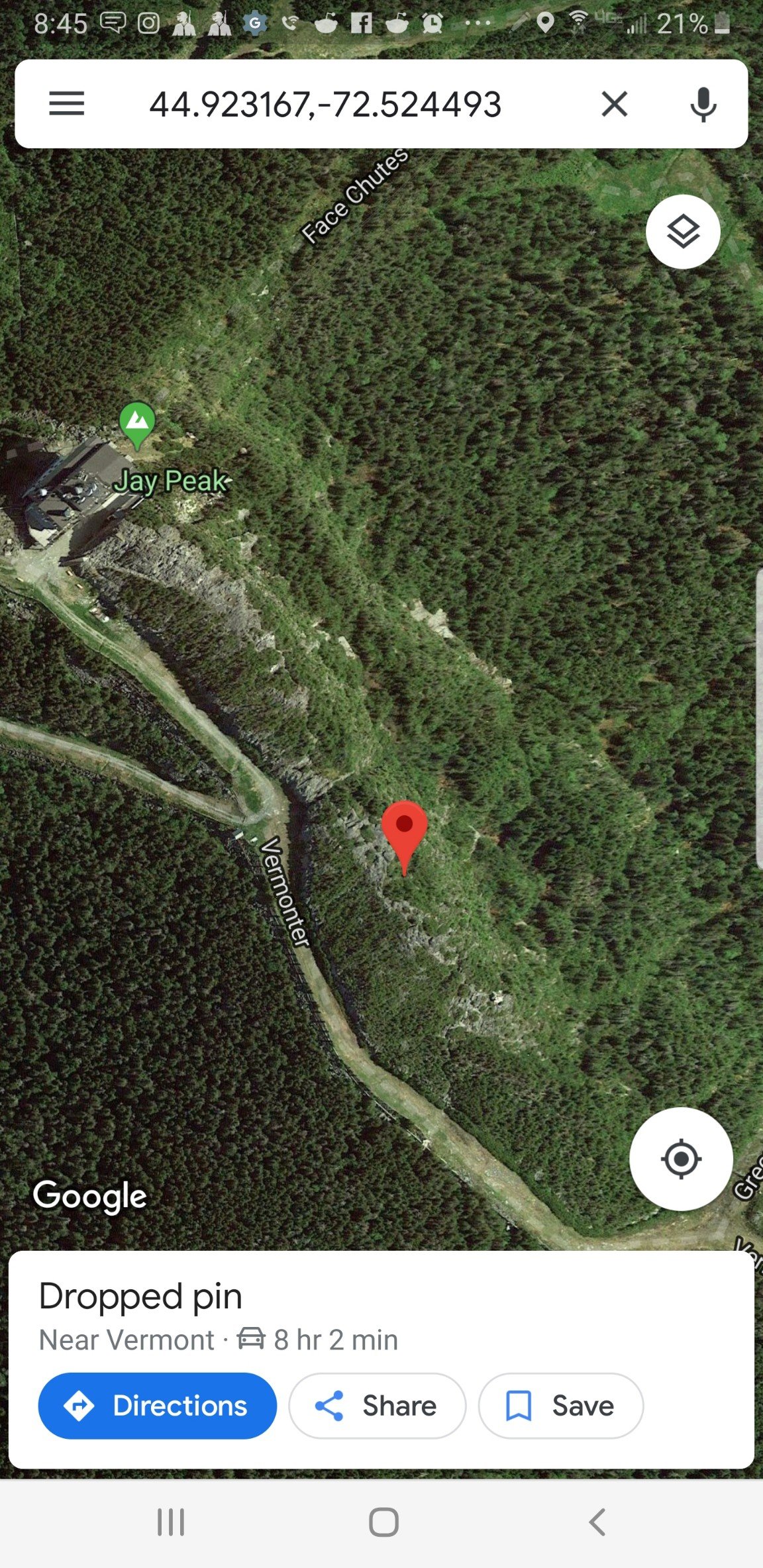
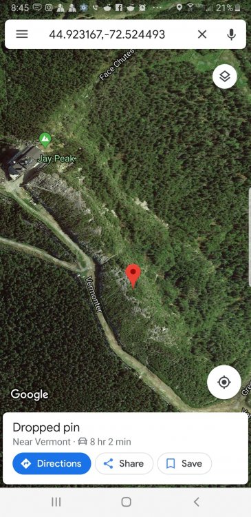
Not sure on the name, right where the access to the shoulder is that has a sign. Is the pumphouse chute the obvious chute straight ahead of that when you climb over the rocks? If so, it's the next chute skiers right on the spine. Noone skied it fir 3 days as far as I could tell, you have to hike down to even see the landing and tell that it's not entirely a cliff. I have a video of a buddy tomahawking down the skiers right line in the chute, I'll upload it when I get back from the store. Here's a satellite screenshot, right below the marker.
-
Jay was awesome Monday through Wednesday. Here's a video of myself dropping a 15-20ft icefall into deep powder on Wednesday. Rode it out nice and clean. The angle its filmed from makes the drop look smaller than it is in reality, but the camera angle really made the landing look sweet!! Truly steep and deep, as this zone collected all the snow, making it about 3ft deep with fresh powder. Edit: reuploaded with better quality copy.
-
Good day at Jay! Still coming down nicely.
-
Just got back to SEPA from a CT work trip early this am. Going to head to mount snow this evening, meet up with buddies and ride there tomorrow. After that smuggs/Jay are on the table for mon/Tues. Should be a nice trip, not the 3+ feet of blower like last time I was in NNE, 1/8-11, but fresh snow is always nice and those northern mountains always ski so much deeper with the wind.
-
What a fun little mountain, their trees are great. I really like the tight pines to skiers right of liftline. Props to everyone that helps clear lines in the offseason.
-
Whiteface should be nice, they reported 11 inches and with the wind stuff will fill in since the end of the storm had decent ratios.
-
Horrible news, stay safe out there. Glad the recent snow helped things out. Is the ice in this picture always brown or is it due to runoff from the rains?