VOLtage
-
Posts
187 -
Joined
-
Last visited
Content Type
Profiles
Blogs
Forums
American Weather
Media Demo
Store
Gallery
Everything posted by VOLtage
-
Not April 27th bad. Maybe April 15th 2011 bad.
-
This was an absolute worst-case scenario with it being a strong tornado, late at night, and a heavily populated area. Praying for Nashville right now.
-

February/March 2020 Winter's Last Chance Thread
VOLtage replied to John1122's topic in Tennessee Valley
And poof... it's gone on the 18z run. -
https://www.spc.noaa.gov/products/md/md0033.html
-
12/10-11/19 Potential Valley Wide Snow Event.
VOLtage replied to John1122's topic in Tennessee Valley
Any sticking up there in Knoxville? -
12/10-11/19 Potential Valley Wide Snow Event.
VOLtage replied to John1122's topic in Tennessee Valley
Not any yet (at least where I live). But there's a solid inch in the grass, and it doesn't seem to be letting up any time soon. -
12/10-11/19 Potential Valley Wide Snow Event.
VOLtage replied to John1122's topic in Tennessee Valley
I can't wrap my mind around why NWS Morristown hasn't at least issued an advisory.- 486 replies
-
- 1
-

-
- snow
- rain to snow
- (and 2 more)
-
https://www.wbir.com/article/weather/the-national-weather-service-confirms-two-tornadoes-formed-friday-in-blount-county/51-b6ec5681-4a7d-4d80-8bca-a9d7f76fe9dc
-
Done
-
Tomorrow's going to be nasty for East Tennessee (where I live unfortunately).
-
-
Keeping a close eye on the line of cells in middle/north Alabama right now. If they don't fizzle out, these could affect the East TN valley.
-
They had better get their act together on an active day like today.
-
TN valley heavy rain/flooding week of whenever
VOLtage replied to janetjanet998's topic in Tennessee Valley
Here's my recorded rainfall since 12:00AM this morning here in Maryville. Here's the recorded rainfall each day of the past week. Adding up the total for each day comes out to 8.52 inches of total rainfall over the past week with more to come tonight. -
TN valley heavy rain/flooding week of whenever
VOLtage replied to janetjanet998's topic in Tennessee Valley
They just issued a PDS Flash Flood Warning for Knox county. The National Weather Service in Morristown has issued a * Flash Flood Warning for... Knox County in east Tennessee... * Until 130 PM EST. * At 1036 AM EST, emergency management reported heavy rain across the warned area. Up to 3 inches of rain have already fallen over the last 3 to 4 hours with an additional 1 to 2 inches possible over the next 2 hours. Flash flooding is already occurring. This is a FLASH FLOOD EMERGENCY for Knoxville. This is a PARTICULARLY DANGEROUS SITUATION. SEEK HIGHER GROUND NOW! * Some locations that will experience flooding include... Knoxville, Oak Ridge, Alcoa, Farragut, Louisville, Plainview, Halls, Blaine, Karns, Kimberlin Heights, House Mountain State Park, Lake Forest, Maloneyville, Mascot, Bearden, Powell and Seymour. PRECAUTIONARY/PREPAREDNESS ACTIONS... Move to higher ground now. This is an extremely dangerous and life-threatening situation. Do not attempt to travel unless you are fleeing an area subject to flooding or under an evacuation order. -
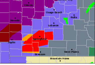
There's tornado warnings and a winter weather advisory going on simultaneously in Southwest Missouri. I don't know if I've seen anything like that before.